- Population
- 14
- 14
- Elevation
- 213 m
- above sea level
- Local time
- UTC+01:00
- Europe/Rome · UTC+01:00
- Airports
- BZO Bolzano Airport12 km
- INN Innsbruck Airport101 km
About Monte
Monte is a village. Location: Vadena/Pfatten, South Tyrol. Population: 14. Elevation: 213 m. The best months to visit are May–June, September. The nearest airport is Bolzano Airport (12 km). Nearby sights include Denti di Cavallo and Monte del Lago.
Photos of Monte
-
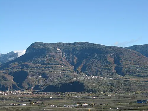
Cima Cucul Plentn · CC0 -
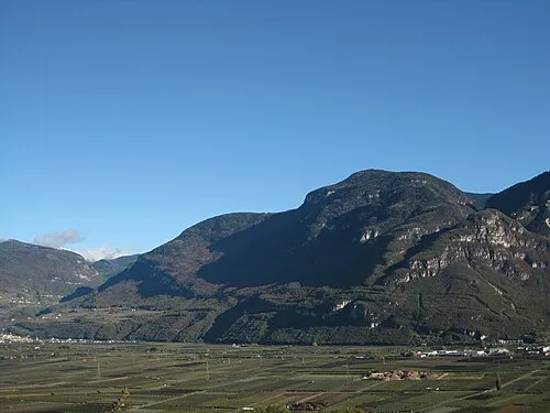
Monte Prato del Re Plentn · CC0


Climate of Monte
Best months for sightseeingBest months for sightseeing: May–June, September.
This month · November
A cold month
Day 11° · Night 4° · Rain 51 mm
- Hottest month
- July (day 28°)
- Coldest month
- January (night 0°)
- Wettest month
- June (81 mm)
- Driest month
- February (26 mm)
Bars: average monthly low and high temperature. Below: precipitation. Monthly averages for 1970–2000 at about 18 km resolution, adjusted for elevation. Highlighted months are mild and relatively dry. Source: WorldClim 2.1 (CC BY 4.0).
Show values as a table
| Month | Jan | Feb | Mar | Apr | May | Jun | Jul | Aug | Sep | Oct | Nov | Dec |
|---|---|---|---|---|---|---|---|---|---|---|---|---|
| Average high (°C) | 7° | 10° | 14° | 17° | 22° | 25° | 28° | 28° | 24° | 18° | 11° | 8° |
| Average low (°C) | 0° | 1° | 4° | 7° | 12° | 15° | 18° | 17° | 14° | 9° | 4° | 1° |
| Precipitation (mm) | 32 | 26 | 36 | 53 | 68 | 81 | 80 | 77 | 67 | 79 | 51 | 35 |
How to get to Monte
The nearest airport is Bolzano Airport (BZO), 12 km to the north as the crow flies. For international flights: Innsbruck Airport (INN) (101 km). The nearest large city is Innsbruck, 101 km to the north.
Airports
- Bolzano Airport (BZO) Bolzano (BZ) 12 kmnorth
- Innsbruck Airport (INN) Innsbruck 101 kmnorth
- Treviso Airport (TSF) Treviso (TV) 106 kmsoutheast
Nearby large cities
- Innsbruck Population: 132.5K 101 kmnorth
- Munich Population: 1.5M 199 kmnorth
- Salzburg Population: 157.2K 209 kmnortheast
- Augsburg Population: 301.1K 226 kmnorth
- Winterthur Population: 111.8K 233 kmnorthwest
Straight-line distances; road distances are longer. Airport data: OurAirports.
Day trips from Monte
Within 100 km: 24 historic and cultural sites, 3,024 natural sites, 132 lakes, rivers and coasts.
0–25 km109 places
- Monte Croce Mountain 22 kmSE
- Dosson Mountain 18 kmSW
- Castel Mountain 23 kmSE
- Dosso di Costalta Mountain 25 kmS
25–60 km857 places
- Spadalone Mountain 50 kmSW
- Piz Gralba Mountain 43 kmNE
- Piz Miara Mountain 44 kmNE
- Croda Nera Mountain 39 kmE
60–100 km2,214 places
- Dosso Rotondo Mountain 67 kmS
- Lago di Poschiavo Lake 92 kmW
- Lago Bianco Lake 97 kmW
- Lej Minor Lake 96 kmW
Straight-line distances.
Nearby attractions & nature
Everything nearby-
Denti di Cavallo Mountain, Vadena/Pfatten1.5 km N
-
Monte del Lago Mountain, Caldaro sulla strada del vino/Kaltern an der Weinstraße3.3 km NW
-
Cima Cucul Mountain, Trodena nel parco naturale/Truden im Naturpark5.7 km SE
-
Col di Sotto Mountain, Caldaro sulla strada del vino/Kaltern an der Weinstraße5.1 km W
-
Sasso di Mezzodì Mountain, Caldaro sulla strada del vino/Kaltern an der Weinstraße5.3 km N
-
Monte Prato del Re Mountain, Egna/Neumarkt7.6 km S
Other cities and towns in Vadena/Pfatten
-
Stadio-Laimburg Village, Vadena/Pfatten2.9 km N
-
 Birti Village, Vadena/Pfatten5.8 km N
-
Vadena Nuova Village, Vadena/Pfatten6.7 km N
-
Caneve Village, Vadena/Pfatten6.4 km N
-
Masetta Village, Vadena/Pfatten7.2 km N
-
Mover Village, Vadena/Pfatten7.7 km N
Sources & licences
Data last updated: