- Population
- 51
- 51
- Elevation
- 45 m
- above sea level
- Local time
- UTC+01:00
- Europe/Rome · UTC+01:00
- Airports
- FLR Florence Airport, Peretola22 km
- PSA Pisa International Airport49 km
About Le Passaiole
Le Passaiole is a village. Location: Quarrata, Province of Pistoia. Population: 51. Elevation: 45 m. The best months to visit are May. The nearest airport is Florence Airport, Peretola (22 km). Nearby sights include Poggio Papinta and Monte Fiore.
Photos of Le Passaiole
-
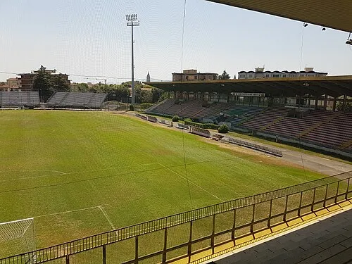
Stadio Marcello Melani Boris Maric · CC0

Climate of Le Passaiole
Best months for sightseeingBest months for sightseeing: May.
This month · November
A wet month
Day 15° · Night 6° · Rain 137 mm
- Hottest month
- August (day 31°)
- Coldest month
- January (night 2°)
- Wettest month
- November (137 mm)
- Driest month
- July (42 mm)
Bars: average monthly low and high temperature. Below: precipitation. Monthly averages for 1970–2000 at about 18 km resolution, adjusted for elevation. Highlighted months are mild and relatively dry. Source: WorldClim 2.1 (CC BY 4.0).
Show values as a table
| Month | Jan | Feb | Mar | Apr | May | Jun | Jul | Aug | Sep | Oct | Nov | Dec |
|---|---|---|---|---|---|---|---|---|---|---|---|---|
| Average high (°C) | 11° | 12° | 15° | 18° | 23° | 27° | 30° | 31° | 26° | 20° | 15° | 11° |
| Average low (°C) | 2° | 3° | 5° | 8° | 12° | 15° | 18° | 18° | 15° | 11° | 6° | 3° |
| Precipitation (mm) | 87 | 75 | 88 | 100 | 73 | 66 | 42 | 68 | 97 | 127 | 137 | 101 |
Other places to visit in this season: May
How to get to Le Passaiole
The nearest airport is Florence Airport, Peretola (FLR), 22 km to the east as the crow flies. The nearest large city is Nice, 297 km to the west.
Airports
- Florence Airport, Peretola (FLR) Firenze (FI) 22 kmeast
- Pisa International Airport (PSA) Pisa (PI) 49 kmsouthwest
- Bologna Guglielmo Marconi Airport (BLQ) Bologna 78 kmnorth
Nearby large cities
- Nice Population: 342.7K 297 kmwest
- Rijeka Population: 108K 321 kmnortheast
- Ljubljana Population: 272.2K 371 kmnortheast
- Innsbruck Population: 132.5K 378 kmnorth
Straight-line distances; road distances are longer. Airport data: OurAirports.
Day trips from Le Passaiole
Within 100 km: 69 historic and cultural sites, 217 natural sites, 28 lakes, rivers and coasts.
0–25 km61 places
- Poggio di Iavello Mountain 15 kmNE
- Monte Morello Mountain 23 kmE
- I Fornelli Mountain 12 kmSE
- Poggio Ferrato Mountain 12 kmNE
25–60 km89 places
- La Lecciona Beach 56 kmW
- Spiaggia Lido di Camaiore Beach 58 kmW
- Spiaggia Viareggio Beach 57 kmW
- Monte Vigese Mountain 38 kmN
60–100 km164 places
- Cormorano Beach 78 kmSW
- Cala del Leone Beach 66 kmSW
- Spiaggia di Calignaia Beach 66 kmSW
- Spiaggia per Cani Beach 65 kmSW
Straight-line distances.
Nearby attractions & nature
Everything nearby-
Poggio Papinta Mountain, Quarrata4.8 km S
-
Monte Fiore Mountain, Lamporecchio4.4 km S
-
Monte Cupoli Mountain, Larciano5.5 km W
-
Sasso Regina Mountain, Quarrata6.4 km S
-
Stadio Marcello Melani Landmark, Pistoia7.7 km N
-
Colle Belvedere Mountain, Serravalle Pistoiese7.1 km W
Sources & licences
Data last updated: · 2 independent sources