
- Population
- 1,283
- 1.3K
- Elevation
- 392 m
- above sea level
- Local time
- UTC+01:00
- Europe/Rome · UTC+01:00
- Places inside
- 6
- listed under Montefranco
- Airports
- PEG Perugia San Francesco d'Assisi – Umbria International Airport59 km
- CIA Ciampino–G. B. Pastine International Airport90 km
About Montefranco
Montefranco is a municipality. Location: Province of Terni, Umbria. Population: 1,283. Elevation: 392 m.
Montefranco is a comune (municipality) in the Province of Terni in the Italian region Umbria, located about 70 km southeast of Perugia and about 10 km northeast of Terni. As of 2021, Montefranco had a population of 1,255 inhabitants.
Source: Wikipedia · CC BY-SA 4.0
Population of Montefranco over time
| 2017 | 1,284 | |
|---|---|---|
| 2018 | 1,304 | |
| 2023 | 1,254 |
Censuses and official estimates; source: Wikidata.
Climate of Montefranco
Best months for sightseeingBest months for sightseeing: May–June, September.
This month · November
Outside the best season
Day 13° · Night 6° · Rain 69 mm
- Hottest month
- July (day 28°)
- Coldest month
- January (night 2°)
- Wettest month
- October (75 mm)
- Driest month
- January (37 mm)
Bars: average monthly low and high temperature. Below: precipitation. Monthly averages for 1970–2000 at about 18 km resolution, adjusted for elevation. Highlighted months are mild and relatively dry. Source: WorldClim 2.1 (CC BY 4.0).
Show values as a table
| Month | Jan | Feb | Mar | Apr | May | Jun | Jul | Aug | Sep | Oct | Nov | Dec |
|---|---|---|---|---|---|---|---|---|---|---|---|---|
| Average high (°C) | 9° | 10° | 13° | 16° | 21° | 25° | 28° | 28° | 24° | 18° | 13° | 9° |
| Average low (°C) | 2° | 2° | 4° | 7° | 11° | 15° | 17° | 17° | 14° | 10° | 6° | 3° |
| Precipitation (mm) | 37 | 43 | 41 | 52 | 58 | 53 | 40 | 47 | 67 | 75 | 69 | 53 |
How to get to Montefranco
The nearest airport is Perugia San Francesco d'Assisi – Umbria International Airport (PEG), 59 km to the north as the crow flies. The nearest large city is Split, 316 km to the east.
Airports
- Perugia San Francesco d'Assisi – Umbria International Airport (PEG) Perugia (PG) 59 kmnorth
- Ciampino–G. B. Pastine International Airport (CIA) Rome 90 kmsouth
- Rome–Fiumicino Leonardo da Vinci International Airport (FCO) Rome 98 kmsouthwest
Nearby large cities
- Split Population: 149.8K 316 kmeast
- Rijeka Population: 108K 332 kmnortheast
Straight-line distances; road distances are longer. Airport data: OurAirports.
Day trips from Montefranco
Within 100 km: 168 historic and cultural sites, 295 natural sites, 15 lakes, rivers and coasts.
0–25 km28 places
- Monte Vagliamenti Mountain 15 kmNW
- Monte Trassiuari Mountain 22 kmSW
- Monte Tilia Mountain 14 kmE
- Monte Terminuto Mountain 11 kmSW
25–60 km144 places
- Valle Cerrese Natural site 29 kmS
- Monte Guaidone Mountain 42 kmNE
- Monte Zoccane Mountain 29 kmS
- Monte Vergozze Mountain 28 kmN
60–100 km306 places
- Appennino Umbro Mountain 65 kmN
- Giulianova Beach Beach 100 kmE
- Boca Do Mar Beach 97 kmSW
- Campo di Mare Beach 92 kmSW
Straight-line distances.
Places in Montefranco
6 places- 1 Montefranco 573
- 2 Fontechiaruccia 364
- 3 I Monti 36
- 4 Varcone 23
- 5 Casa Cantoniera 21
- 6 Capitignano 20
Bar: population relative to the most populous place in this list.
Nearby attractions & nature
Everything nearby-
Monte Petano Mountain, Ferentillo5.6 km E
-
Monte Solenne Mountain, Ferentillo7.2 km NE
-
Monte Fionchi Mountain, Spoleto7.6 km N
-
Cima del Carpellone Mountain, Monteleone di Spoleto11 km E
-
Monte Motola Mountain, Monteleone di Spoleto12 km NE
-
Monte Lungo Mountain, Colli sul Velino11 km S
-
Monte Terminuto Mountain, Stroncone11 km SW
-
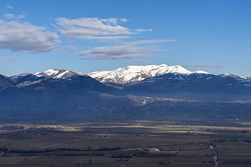 Monte Terminillo Mountain, Micigliano24 km SE
Sources & licences
Data last updated: · 2 independent sources