Yurihonjō
Local name: 由利本荘市
Located in Yuri-honjō Shi, Akita Coordinates: 39°23′22″ N 140°03′29″ E
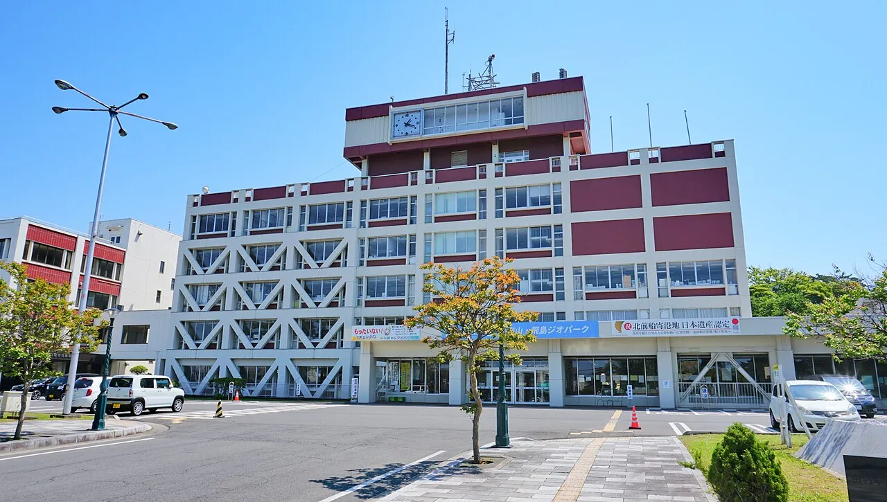
- Population
- 76,077
- 76.1K
- Elevation
- 4 m
- above sea level
- Local time
- UTC+09:00
- Asia/Tokyo · UTC+09:00
- Airports
- AXT Akita Airport29 km
- SYO Shonai Airport68 km
About Yurihonjō
Yurihonjō is a city. Location: Yuri-honjō Shi, Akita. Population: 76,077. Elevation: 4 m.
Yurihonjō (由利本荘市, Yurihonjō-shi) is a city located in Akita Prefecture, Japan. As of 28 February 2023, the city has an estimated population of 72,550 in 30,750 households, and a population density of 60 inhabitants per square kilometre (160/sq mi). The total area of the city is 1,209.59 square kilometres (467.03 sq mi).
Source: Wikipedia · CC BY-SA 4.0
Photos of Yurihonjō
-

Immanuelle · CC BY 4.0 -

掬茶 · CC BY-SA 4.0 -

掬茶 · CC BY-SA 3.0 -

カスタヌー · CC BY-SA 3.0


Travel notes for Yurihonjō
From Wikivoyage
Yurihonjo (由利本荘市 Yurihonjō-shi) is a city in southern Akita Prefecture. It was formed in 2005 by the merger of many towns: Chokai, Higashi Yuri, Nishime, Iwaki, Honjo, Yashima, and Yuri.
Understand+
Yurihonjo was formed by a merger of several towns, yet those towns are still largely oriented around themselves. And since Yurihonjo is very large, in terms of area, people living in the SE may know nothing about people living in the NW, for example. Honjo (本荘) is in the west of Yurihonjo. To the south of Honjo is Nishime (西目). To the north of Honjo are Matsugasaki (松ヶ崎), Kameda (亀田), and Iwaki (岩城). Ouchi (大内) is NE of Honjo. Higashi Yuri (東由利) is east of Honjo. In the SE are Yuri (由利), Yashima (矢島), and Chokai (鳥海). Chokai is composed of three villages, Kawauchi (川内), Hitane, (直根), and Jinego (笹子).
History:
Honjo, located at the heart of Yurihonjo, is a city surrounded by hills ("Dewa-kyuryo"), plateaus ("Yuri-hara") and the sea. It is believed that the area of Honjo was under the sea about 1,000,000 years ago and that its higher zones started gradually emerging some 500,000 years later. By 3000 B.C., some large villages had been formed at the foot of the Dewa-kyuryo.
The name Yuri appeared for the first time in "Azumakagami", a book written around 1200. The Yuri clan was a powerful family who governed Nikaho, Yashima, Koyoshi and other neighboring districts. Their territories, however, were confiscated by the government in 1213, and for the following 400 years up to 12 clans ruled over the area together. In the early 17th century, the area was disputed between the government and the local clans. It finally became the property of the Rokugo clan from Ibaraki in 1623 and remained so for about 250 years.
There once was a castle in Honjo, located on the site of today's Honjo Park. As a matter of fact, the old way of writing Honjo, 本城, means "main castle". However this castle can no longer be seen as it was burnt down in 1868 by the members of the Rokugo clan themselves at the end of their reign.
Get in+
Depending where you're going, a car is probably your best bet.
By car:
Within Akita, cars are the most convenient way to get around. Highway 7 connects Honjo with Akita to the north, by way of Iwaki, and Nikaho to the south, by way of Nishime. Highway 105 connects Honjo to Daisen in the NE, by way of Ouchi. Highway 107 connects Honjo to Ugo and Yokote in the east, by way of Higashi Yuri. Highway 108 connects Honjo to Yuzawa in the SE, by way of Yuri, Yashima and Chokai. There are several small highways through the mountains, but some of them are seasonal or are closed for long-term repairs, so ask someone locally and check. In the winter, the roads can be snowy and icy, and the mountain areas — Chokai, for example — get tons of snow.
By train:
From Ugohonjo Station in Honjo, the Akebono night train goes direct to Tokyo, and the Nihonkai night train goes direct to Kyoto. The nearest shinkansen stations are the Komachi Shinkansen in Akita or Omagari, and the Tsubasa Shinkansen in Shinjo, northern Yamagata. Both of these shinkansen lines go to Tokyo. There are many daily trains going north and south out of Honjo. There is also a private train line that goes from Ugohonjo Station to Yashima, by way of Yuri.
1 Ugohonjo Station (羽後本荘駅 Ugohonjō-eki), Nishibonten 85-1, ☏ +81 184-22-0221. The main train station in Yurihonjo.
2 Yashima Station (矢島駅 Yashima-eki), Hazaka, Nanokamachi, Yashima (2 blocks SW of the Yashima Police Station, and well-signed), ☏ +81 184 56-2036. 05:30-21:10. The terminus of the Yuri Kogen Railway. This station has a large sitting area and a computer with free internet.
Yuri Kogen Railway (由利高原鉄道 Yurikōgen tetsudō), Hazaka 21-2, Nanokamachi, Yashima, ☏ +81 184 56-2736, fax: +81 184 56-2850, info@obako5.com. This railway runs from Ugohonjo Station to Yashima by way of Yuri. Trains leave around once an hour; see the website for the schedule.
By bus:
Source: Wikivoyage · CC BY-SA 4.0 · abridged
Places bordering Yurihonjō
- Nikaho-shi
- Daisen
- Yokote
- Yuzawa
- Ugo Machi
- Yuza
- Mamurogawa Machi
- Sakata
Twin towns and sister cities of Yurihonjō
- Marugame· Japan
- Saku· Japan
- Takamatsu Shi· Japan
- Vác· Hungary
- Iwaki-shi· Japan
Source: Wikidata. Only places with a page on this site are shown.
Population of Yurihonjō over time
| 2010 | 85,229 | |
|---|---|---|
| 2015 | 79,927 | |
| 2021 | 73,840 |
Censuses and official estimates; source: Wikidata.
Climate of Yurihonjō
Best months for sightseeingBest months for sightseeing: May–June, September.
This month · November
A wet month
Day 12° · Night 4° · Rain 171 mm
- Hottest month
- August (day 29°)
- Coldest month
- February (night -3°)
- Wettest month
- December (182 mm)
- Driest month
- May (97 mm)
Bars: average monthly low and high temperature. Below: precipitation. Monthly averages for 1970–2000 at about 18 km resolution, adjusted for elevation. Highlighted months are mild and relatively dry. Source: WorldClim 2.1 (CC BY 4.0).
Show values as a table
| Month | Jan | Feb | Mar | Apr | May | Jun | Jul | Aug | Sep | Oct | Nov | Dec |
|---|---|---|---|---|---|---|---|---|---|---|---|---|
| Average high (°C) | 3° | 3° | 7° | 13° | 19° | 22° | 26° | 29° | 24° | 18° | 12° | 6° |
| Average low (°C) | -3° | -3° | -1° | 5° | 10° | 15° | 20° | 21° | 16° | 10° | 4° | 0° |
| Precipitation (mm) | 153 | 120 | 105 | 105 | 97 | 125 | 176 | 157 | 168 | 152 | 171 | 182 |
How to get to Yurihonjō
The nearest airport is Akita Airport (AXT), 29 km to the northeast as the crow flies. The nearest large city is Akita, 37 km to the north.
Airports
- Akita Airport (AXT) Akita 29 kmnortheast
- Shonai Airport (SYO) Shonai 68 kmsouth
- Iwate Hanamaki Airport (HNA) Hanamaki 93 kmeast
Nearby large cities
- Akita Population: 307.7K 37 kmnorth
- Sakata Population: 100.3K 55 kmsouth
- Tsuruoka Population: 125.4K 77 kmsouth
- Ōshū Population: 112.9K 100 kmeast
- Morioka Population: 290.7K 100 kmeast
Straight-line distances; road distances are longer. Airport data: OurAirports.
Day trips from Yurihonjō
Within 100 km: 2 historic and cultural sites, 11 natural sites, 13 lakes, rivers and coasts.
0–25 km1 place
- Koyoshi River River 4 kmW
25–60 km6 places
- Tobi Shima Island 49 kmSW
- Akita Port Tower Landmark 40 kmN
- Mount Chōkai Mountain 32 kmS
- Omono River River 34 kmN
60–100 km19 places
- Waga River River 93 kmE
- Dewa Sanzan Mountain 84 kmS
- Aka River River 65 kmS
- Oga Quasi National Park Natural site 64 kmNW
Straight-line distances.
Yurihonjō and similar cities
Side by side with cities of similar size in the same country: population, elevation and climate.
| Measure | Yurihonjō | Shibukawa | Kiyose | Aira |
|---|---|---|---|---|
| Population | 76.1K | 76.1K | 76.2K | 76.3K |
| Elevation | 4 m | 202 m | 53 m | 76 m |
| Summer day (hottest month) | 29° | 30° | 30° | 31° |
| Winter night (coldest month) | -3° | -3° | -1° | 2° |
| Annual rainfall | 1,711 mm | 1,337 mm | 1,461 mm | 2,342 mm |
| Best months | May–Jun, Sep | May | May–Jun, Oct | May, Oct–Nov |
| Distance | — | 336 km | 403 km | 1,203 km |
Climate values are 1970–2000 monthly averages; straight-line distance.
Sources & licences
Data last updated: · 2 independent sources