- Population
- 18,503
- 18.5K
- Elevation
- 9 m
- above sea level
- Local time
- UTC+09:00
- Asia/Tokyo · UTC+09:00
- Places inside
- 1
- listed under Kitagata Chō
- Airports
- NKM Nagoya Airport / JASDF Komaki Air Base29 km
- NGO Chubu Centrair International Airport64 km
About Kitagata Chō
Kitagata Chō is a municipality. Location: Motosu-gun, Gifu. Population: 18,503. Elevation: 9 m.
Kitagata (北方町, Kitagata-chō) is a town located in Motosu District, Gifu Prefecture, Japan. As of 1 November 2018, the town had an estimated population of 18,410 and a population density of 3600 persons per km2, in 7,449 households. The total area of the town was 5.18 square kilometres (2.00 sq mi). It is the smallest town in Gifu Prefecture in terms of area.
Source: Wikipedia · CC BY-SA 4.0
Places bordering Kitagata Chō
- Gifu
- Mizuho Shi
- Motosu
Population of Kitagata Chō over time
| 2010 | 18,395 | |
|---|---|---|
| 2015 | 18,169 | |
| 2020 | 18,308 |
Censuses and official estimates; source: Wikidata.
Climate of Kitagata Chō
Best months for sightseeingBest months for sightseeing: May–June, October.
This month · November
Outside the best season
Day 16° · Night 7° · Rain 99 mm
Better nearby cities in November
- Kofu · 172 km east17°
- Fujinomiya · 176 km east18°
- Fuji · 183 km east20°
- Hottest month
- August (day 32°)
- Coldest month
- January (night 0°)
- Wettest month
- July (281 mm)
- Driest month
- December (65 mm)
Bars: average monthly low and high temperature. Below: precipitation. Monthly averages for 1970–2000 at about 18 km resolution, adjusted for elevation. Highlighted months are mild and relatively dry. Source: WorldClim 2.1 (CC BY 4.0).
Show values as a table
| Month | Jan | Feb | Mar | Apr | May | Jun | Jul | Aug | Sep | Oct | Nov | Dec |
|---|---|---|---|---|---|---|---|---|---|---|---|---|
| Average high (°C) | 8° | 9° | 13° | 19° | 23° | 26° | 30° | 32° | 27° | 22° | 16° | 11° |
| Average low (°C) | 0° | 0° | 3° | 9° | 13° | 18° | 22° | 23° | 19° | 13° | 7° | 2° |
| Precipitation (mm) | 76 | 92 | 137 | 193 | 191 | 279 | 281 | 179 | 253 | 139 | 99 | 65 |
How to get to Kitagata Chō
The nearest airport is Nagoya Airport / JASDF Komaki Air Base (NKM), 29 km to the southeast as the crow flies. For international flights: Chubu Centrair International Airport (NGO) (64 km). The nearest large city is Gifu, 6 km to the east.
Airports
- Nagoya Airport / JASDF Komaki Air Base (NKM) Nagoya 29 kmsoutheast
- Chubu Centrair International Airport (NGO) Tokoname 64 kmsouth
- Komatsu Airport / JASDF Komatsu Air Base (KMQ) Kanazawa 110 kmnorth
Nearby large cities
- Gifu Population: 402.6K 6 kmeast
- Ōgaki Population: 161.5K 11 kmsouthwest
- Kakamigahara Population: 144.5K 16 kmeast
- Ichinomiya Population: 380.1K 18 kmsoutheast
- Inazawa Population: 134.8K 22 kmsoutheast
Straight-line distances; road distances are longer. Airport data: OurAirports.
Day trips from Kitagata Chō
Within 100 km: 23 historic and cultural sites, 25 natural sites, 28 lakes, rivers and coasts.
0–25 km3 places
- Tsubo-gawa River 15 kmE
- Inuyama castle Historic site 23 kmE
- Neo River River 5 kmSW
25–60 km23 places
- Toyota Stadium Landmark 58 kmSE
- Lake Biwa Lake 59 kmW
- Chikubu Island Island 50 kmW
- Mount Ryōzen Mountain 33 kmSW
60–100 km50 places
- Himakajima Island 85 kmS
- Lake Suigetsu Lake 75 kmW
- Mimi River River 71 kmW
- Kita-gawa River 86 kmW
Straight-line distances.
Places in Kitagata Chō
1 placeBar: population relative to the most populous place in this list.
Nearby attractions & nature
Everything nearby-
Neo River River, Gifu5.2 km SW
-
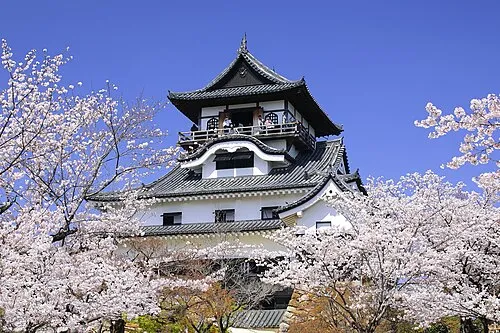 Inuyama castle Historic site, Inuyama-shi23 km E
-
Tsubo-gawa River, Gifu15 km E
Sources & licences
Data last updated: · 2 independent sources