- Elevation
- 234 m
- above sea level
- Local time
- UTC+09:00
- Asia/Tokyo · UTC+09:00
- Population
- 3,343
- 3.3K
- Airports
- OIR Okushiri Airport10 km
- HKD Hakodate Airport120 km
About Okushiri Island
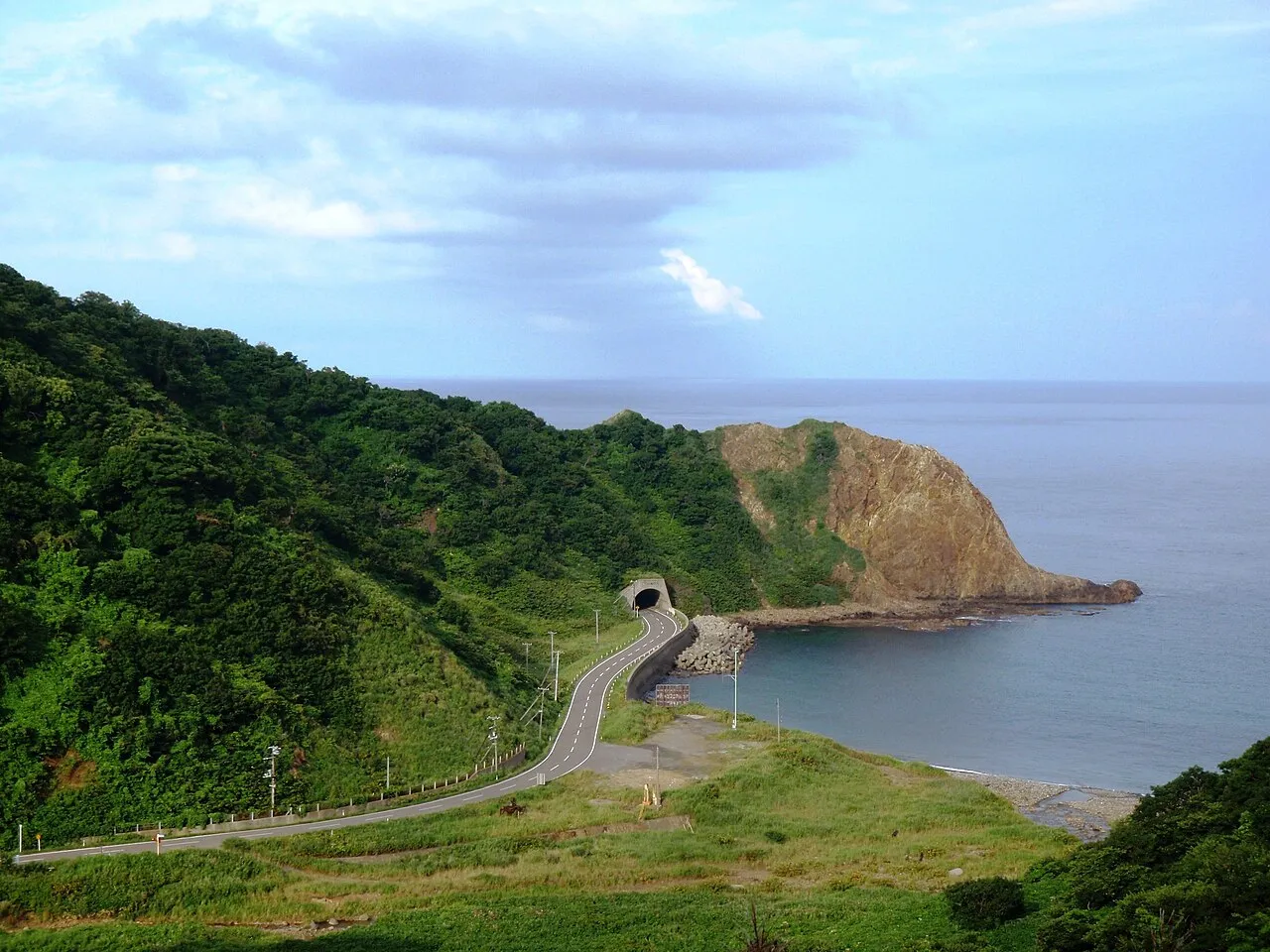
Okushiri Island is an island. Location: Okushiri Chō, Okushiri-gun. Population: 3,343.
Okushiri Island (奥尻島, Okushiri-tō) is an island in Hokkaidō, Japan. It has an area of 142.97 square kilometres (55.20 sq mi). The town of Okushiri and the Hiyama Prefectural Natural Park encompass the entire island. It has many pastures, beech tree forests, and a rocky coastline. There are two elementary schools, one junior high school, and one senior high school. Okushiri currently has no colleges or universities.
Source: Wikipedia · CC BY-SA 4.0
At a glance
- Area
- 143 km²
Source: Wikidata
Photos of Okushiri Island
-

United Kingdom Hydrographic Office · Public domain -

ブルーノ・プラス · CC BY 4.0 -

Soica2001 · Public domain


Travel notes for Okushiri Island
From Wikivoyage
Okushiri Island (奥尻島 Okushiri-tō) is an island off the southwest coast of Hokkaido, Japan.
Understand+
Okushiri is a rugged, deeply forested remote island famous for its crystal-clear "Okushiri Blue" waters and striking coastal rock formations. The name originates from the Ainu Ikusunsir, "Other Side Island", somewhat unfortunately phonetically rendered with Chinese characters meaning "Deep Butt".
History:
The island was devastated by a massive earthquake in 1993 that triggered a tsunami, landslides and fires, killing 198 people. The island has since been completely rebuilt with extensive coastal defenses, but it never really recovered and the population has continued to shrink, with only around 3,000 people left as of 2025.
Climate:
The island experiences a humid continental climate with cool summer ocean breezes and heavy snowfall during the winter months.
Visitor information:
Unimaru is run by the Okushiri Tourism Association.
Okushiri Town has a tourism section with automatic translation.
Get in+
By plane:
1 Okushiri Airport (OIR IATA) is served by JAL subsidiary Hokkaido Air System (HAC) with flights from Hakodate and Sapporo-Okadama.
By ferry:
Heartland Ferry runs a daily ferry from Esashi (2 hours 20 minutes, ¥3,460 in 2nd class) to 2 Okushiri Port.
Source: Wikivoyage · CC BY-SA 4.0 · abridged
Climate of Okushiri Island
Best months for sightseeingBest months for sightseeing: July–August.
This month · November
A wet month
Day 7° · Night 3° · Rain 110 mm
- Hottest month
- August (day 23°)
- Coldest month
- January (night -5°)
- Wettest month
- September (161 mm)
- Driest month
- March (80 mm)
Bars: average monthly low and high temperature. Below: precipitation. Monthly averages for 1970–2000 at about 18 km resolution, adjusted for elevation. Highlighted months are mild and relatively dry. Source: WorldClim 2.1 (CC BY 4.0).
Show values as a table
| Month | Jan | Feb | Mar | Apr | May | Jun | Jul | Aug | Sep | Oct | Nov | Dec |
|---|---|---|---|---|---|---|---|---|---|---|---|---|
| Average high (°C) | -3° | -2° | 2° | 9° | 13° | 17° | 21° | 23° | 20° | 14° | 7° | 1° |
| Average low (°C) | -5° | -4° | -1° | 4° | 8° | 13° | 18° | 20° | 16° | 10° | 3° | -2° |
| Precipitation (mm) | 102 | 82 | 80 | 91 | 95 | 97 | 141 | 141 | 161 | 119 | 110 | 99 |
How to get to Okushiri Island
The nearest airport is Okushiri Airport (OIR), 10 km to the south as the crow flies. For international flights: Hakodate Airport (HKD) (120 km). The nearest large city is Hakodate, 113 km to the east.
Airports
- Okushiri Airport (OIR) Okushiri Island 10 kmsouth
- Hakodate Airport (HKD) Hakodate 120 kmeast
- Aomori Airport (AOJ) Aomori 188 kmsoutheast
Nearby large cities
- Hakodate Population: 275.7K 113 kmeast
- Otaru Population: 115.3K 170 kmnortheast
- Aomori Population: 298.4K 183 kmsoutheast
- Tomakomai Population: 174.8K 184 kmeast
- Sapporo Population: 2M 184 kmnortheast
Straight-line distances; road distances are longer. Airport data: OurAirports.
Day trips from Okushiri Island
Within 100 km: 1 historic or cultural site, 5 natural sites, 6 lakes, rivers and coasts.
0–25 km2 places
- Mount Kamui Mountain 2 kmW
- Mount Katsuma Mountain 4 kmN
25–60 km2 places
- Makomanai-gawa River 42 kmNE
- Shiribeshi-Toshibetsu River River 43 kmNE
60–100 km8 places
- Mount Nagayama Mountain 89 kmSE
- Kamome Island Island 62 kmSE
- Oshima Peninsula Natural site 87 kmE
- Amanogawa River River 66 kmSE
Straight-line distances.
Nearest towns and villages
-
Okushiri Village, Okushiri Chō3.8 km NE
-
 Setana Chō Municipality, Kudō-gun44 km NE
-
Setana Town, Setana Chō45 km NE
-
Otobe Village, Otobe Chō59 km E
Nearby attractions & nature
Everything nearby-
Mount Kamui Mountain, Okushiri Chō2.2 km W
-
Mount Katsuma Mountain, Okushiri Chō4.2 km N
Sources & licences
Data last updated: · 2 independent sources