- Population
- 5,558
- 5.6K
- Elevation
- 101 m
- above sea level
- Local time
- UTC+09:00
- Asia/Tokyo · UTC+09:00
- Places inside
- 1
- listed under Shibetsu Chō
- Airports
- SHB Nakashibetsu Airport18 km
- MMB Memanbetsu Airport67 km
About Shibetsu Chō
Shibetsu Chō is a municipality. Location: Shibetsu-gun, Hokkaido. Population: 5,558. Elevation: 101 m.
Shibetsu (標津町, Shibetsu-chō) is a town located in Nemuro Subprefecture, Hokkaido, Japan.
Source: Wikipedia · CC BY-SA 4.0
Travel notes for Shibetsu Chō
From Wikivoyage
Shibetsu (標津) is a town in Nemuro, Hokkaido.
Understand+
Tourist information site:
The local tourist association has a Japanese-only guide site.
Get in+
By plane:
Nearby Nemuro Nakashibetsu Airport has flights from Sapporo's New Chitose airport and Tokyo's Haneda Airport.
By bus:
Akan Bus operates bus services from Kushiro, Nakashibetsu, Nemuro, Rausu and Utoro, Shari.
Source: Wikivoyage · CC BY-SA 4.0 · abridged
Places bordering Shibetsu Chō
- bekkai
- Nakashibetsu Chō
- Rausu Chō
- Kiyosato Chō
- Shari Chō
Population of Shibetsu Chō over time
| 2010 | 5,646 | |
|---|---|---|
| 2015 | 5,242 | |
| 2020 | 5,123 |
Censuses and official estimates; source: Wikidata.
Climate of Shibetsu Chō
Best months for sightseeingBest months for sightseeing: July–August.
This month · November
A cold month
Day 8° · Night 2° · Rain 82 mm
- Hottest month
- August (day 22°)
- Coldest month
- February (night -8°)
- Wettest month
- September (164 mm)
- Driest month
- February (48 mm)
Bars: average monthly low and high temperature. Below: precipitation. Monthly averages for 1970–2000 at about 18 km resolution, adjusted for elevation. Highlighted months are mild and relatively dry. Source: WorldClim 2.1 (CC BY 4.0).
Show values as a table
| Month | Jan | Feb | Mar | Apr | May | Jun | Jul | Aug | Sep | Oct | Nov | Dec |
|---|---|---|---|---|---|---|---|---|---|---|---|---|
| Average high (°C) | -2° | -2° | 1° | 7° | 14° | 17° | 20° | 22° | 19° | 14° | 8° | 1° |
| Average low (°C) | -8° | -8° | -4° | 2° | 7° | 11° | 15° | 18° | 15° | 9° | 2° | -4° |
| Precipitation (mm) | 64 | 48 | 76 | 80 | 94 | 85 | 98 | 126 | 164 | 118 | 82 | 56 |
How to get to Shibetsu Chō
The nearest airport is Nakashibetsu Airport (SHB), 18 km to the south as the crow flies. The nearest large city is Kitami, 87 km to the west.
Airports
- Nakashibetsu Airport (SHB) Nakashibetsu 18 kmsouth
- Memanbetsu Airport (MMB) Ōzora 67 kmwest
- Kushiro Airport (KUH) Kushiro 100 kmsouthwest
Nearby large cities
- Kitami Population: 119.1K 87 kmwest
- Kushiro Population: 167.9K 98 kmsouthwest
- Obihiro Population: 166.5K 170 kmsouthwest
- Asahikawa Population: 333.5K 210 kmwest
- Ebetsu Population: 134K 286 kmwest
Straight-line distances; road distances are longer. Airport data: OurAirports.
Places in Shibetsu Chō
1 placeBar: population relative to the most populous place in this list.
Nearby attractions & nature
Everything nearby-
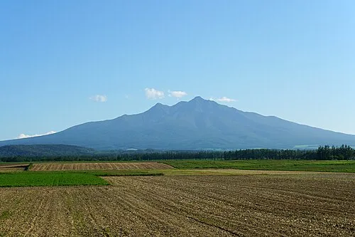 Shari Dake Mountain, Shari Chō21 km W
-
 Mount Samakke Nupuri Mountain, Nakashibetsu Chō20 km W
-
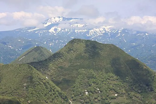 Mount Unabetsu Mountain, Shari Chō17 km NW
-
 Shibetsu Dake Mountain, Kiyosato Chō23 km W
-
Shibetsu River River, Japan15 km SE
Sources & licences
Data last updated: · 2 independent sources