
- Population
- 16,263
- 16.3K
- Elevation
- 192 m
- above sea level
- Local time
- UTC+09:00
- Asia/Tokyo · UTC+09:00
- Airports
- HNA Iwate Hanamaki Airport32 km
- AXT Akita Airport66 km
About Shizukuishi
Shizukuishi is a town. Location: Shizukuishi Chō, Iwate-gun. Population: 16,263. Elevation: 192 m.
Shizukuishi (雫石町, Shizukuishi-chō) is a town located in Iwate Prefecture, Japan. As of 31 March 2020, the town had an estimated population of 16,263 in 6354 households, and a population density of 27 persons per km2. The total area of the town is 608.82 square kilometres (235.07 sq mi).
Source: Wikipedia · CC BY-SA 4.0
Photos of Shizukuishi
-

フルスイング · CC BY-SA 4.0 -

掬茶 · CC BY-SA 4.0 -

掬茶 · CC BY-SA 4.0 -

Ebiebi2 · CC0 -

Ebiebi2 · CC0


Places bordering Shizukuishi
- Morioka
- Hanamaki
- Hachimantai
- Takizawa-shi
- Yahaba Chō
- Shiwa Chō
- Nishiwaga Machi
- Semboku-shi
Twin towns and sister cities of Shizukuishi
- Fuji· Japan
Source: Wikidata. Only places with a page on this site are shown.
Population of Shizukuishi over time
| 2010 | 18,033 | |
|---|---|---|
| 2015 | 16,981 | |
| 2021 | 15,589 |
Censuses and official estimates; source: Wikidata.
Climate of Shizukuishi
Best months for sightseeingBest months for sightseeing: May–June, September.
This month · November
A wet month
Day 11° · Night 2° · Rain 114 mm
- Hottest month
- August (day 28°)
- Coldest month
- January (night -6°)
- Wettest month
- July (184 mm)
- Driest month
- February (80 mm)
Bars: average monthly low and high temperature. Below: precipitation. Monthly averages for 1970–2000 at about 18 km resolution, adjusted for elevation. Highlighted months are mild and relatively dry. Source: WorldClim 2.1 (CC BY 4.0).
Show values as a table
| Month | Jan | Feb | Mar | Apr | May | Jun | Jul | Aug | Sep | Oct | Nov | Dec |
|---|---|---|---|---|---|---|---|---|---|---|---|---|
| Average high (°C) | 1° | 2° | 5° | 13° | 19° | 23° | 26° | 28° | 23° | 17° | 11° | 4° |
| Average low (°C) | -6° | -6° | -3° | 3° | 9° | 14° | 19° | 20° | 15° | 8° | 2° | -3° |
| Precipitation (mm) | 94 | 80 | 92 | 105 | 102 | 126 | 184 | 182 | 175 | 121 | 114 | 106 |
How to get to Shizukuishi
The nearest airport is Iwate Hanamaki Airport (HNA), 32 km to the southeast as the crow flies. The nearest large city is Morioka, 14 km to the east.
Airports
- Iwate Hanamaki Airport (HNA) Hanamaki 32 kmsoutheast
- Akita Airport (AXT) Akita 66 kmwest
- Odate Noshiro Airport (ONJ) Kitaakita 76 kmnorthwest
Nearby large cities
- Morioka Population: 290.7K 14 kmeast
- Ōshū Population: 112.9K 64 kmsouth
- Akita Population: 307.7K 74 kmwest
- Ichinoseki Population: 114.5K 87 kmsouth
- Hachinohe Population: 239K 100 kmnortheast
Straight-line distances; road distances are longer. Airport data: OurAirports.
Day trips from Shizukuishi
Within 100 km: 2 historic and cultural sites, 7 natural sites, 14 lakes, rivers and coasts.
0–25 km3 places
- Iwate San Mountain 17 kmN
- Mount Akita-Komagatake Mountain 17 kmNW
- Shizukuishi River River 14 kmE
25–60 km9 places
- Sarugaishi River River 35 kmS
- Kinu Gawa River 40 kmSE
- Anano River River 29 kmS
- Lake Tazawa Lake 27 kmW
60–100 km11 places
- Koyoshi River River 90 kmW
- Akita Port Tower Landmark 79 kmW
- Hachirō Lagoon Lake 88 kmW
- Miyako Bay Natural site 87 kmE
Straight-line distances.
Nearby attractions & nature
Everything nearby-
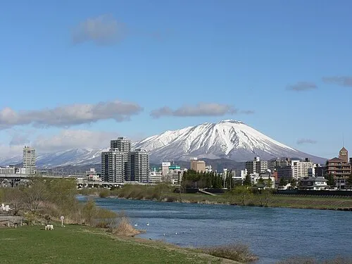 Iwate San Mountain, Iwate-gun17 km N
-
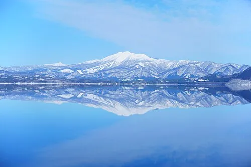 Mount Akita-Komagatake Mountain, Japan17 km NW
-
Shizukuishi River River, Iwate14 km E
Sources & licences
Data last updated: · 2 independent sources