Gmina Nowy Staw
Located in Malbork County, Pomeranian Voivodeship Coordinates: 54°08′20″ N 19°00′35″ E
- Population
- 7,651
- 7.7K
- Elevation
- 2 m
- above sea level
- Local time
- UTC+01:00
- Europe/Warsaw · UTC+01:00
- Places inside
- 1
- listed under Gmina Nowy Staw
- Airports
- GDN Gdańsk Lech Wałęsa Airport44 km
- KGD Khrabrovo Airport133 km
About Gmina Nowy Staw
Gmina Nowy Staw is a municipality. Location: Malbork County, Pomeranian Voivodeship. Population: 7,651. Elevation: 2 m. The best months to visit are June–August. The nearest airport is Gdańsk Lech Wałęsa Airport (44 km). Nearby sights include Trutenau Concentration Camp and Stutthof Concentration Camp.
Climate of Gmina Nowy Staw
Best months for sightseeingBest months for sightseeing: June–August.
This month · November
A cold month
Day 6° · Night 1° · Rain 50 mm
- Hottest month
- August (day 23°)
- Coldest month
- January (night -4°)
- Wettest month
- July (79 mm)
- Driest month
- February (28 mm)
Bars: average monthly low and high temperature. Below: precipitation. Monthly averages for 1970–2000 at about 18 km resolution, adjusted for elevation. Highlighted months are mild and relatively dry. Source: WorldClim 2.1 (CC BY 4.0).
Show values as a table
| Month | Jan | Feb | Mar | Apr | May | Jun | Jul | Aug | Sep | Oct | Nov | Dec |
|---|---|---|---|---|---|---|---|---|---|---|---|---|
| Average high (°C) | 1° | 2° | 6° | 12° | 18° | 20° | 22° | 23° | 18° | 12° | 6° | 2° |
| Average low (°C) | -4° | -4° | -1° | 3° | 7° | 11° | 13° | 12° | 9° | 5° | 1° | -2° |
| Precipitation (mm) | 36 | 28 | 31 | 36 | 48 | 74 | 79 | 72 | 68 | 57 | 50 | 48 |
How to get to Gmina Nowy Staw
The nearest airport is Gdańsk Lech Wałęsa Airport (GDN), 44 km to the northwest as the crow flies. The nearest large city is Klaipėda, 222 km to the northeast.
Airports
- Gdańsk Lech Wałęsa Airport (GDN) Gdańsk 44 kmnorthwest
- Khrabrovo Airport (KGD) Kaliningrad 133 kmnortheast
- Ignacy Jan Paderewski Bydgoszcz Airport (BZG) Bydgoszcz 135 kmsouthwest
Nearby large cities
- Klaipėda Population: 172.3K 222 kmnortheast
- Kaunas Population: 289.4K 328 kmeast
Straight-line distances; road distances are longer. Airport data: OurAirports.
Day trips from Gmina Nowy Staw
Within 100 km: 42 historic and cultural sites, 31 natural sites, 1 lake, river or coast.
0–25 km7 places
- Steegen Concentration Camp (Oberforstamt) Historic site 22 kmN
- Zeyersniederkampen Concentration Camp Historic site 23 kmNE
- Stutthof Concentration Camp Historic site 23 kmNE
- Schönwarling I Concentration Camp Historic site 22 kmW
25–60 km43 places
- Wzgorza nad Szczodrowem S Mountain 41 kmW
- Wyżyna Elbląska Natural site 34 kmE
- Dörbeck Concentration Camp Historic site 31 kmE
- Pröbbernau Concentration Camp Historic site 33 kmNE
60–100 km24 places
- Gruppe bei Graudenz Concentration Camp Historic site 75 kmS
- Wlk. Klincz 178 Mountain 63 kmW
- Jastrzębia Góra Mountain 88 kmNW
- Kolkau Concentration Camp Historic site 89 kmNW
Straight-line distances.
Places in Gmina Nowy Staw
1 placeBar: population relative to the most populous place in this list.
Nearby attractions & nature
Everything nearby-
Trutenau Concentration Camp Historic site, Gmina Cedry Wielkie17 km NW
-
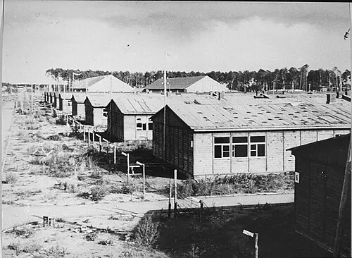 Stutthof Concentration Camp Historic site, Gmina Sztutowo23 km NE
-
Käsemark Concentration Camp Historic site, Gmina Cedry Wielkie14 km N
-
Steegen Concentration Camp (Oberforstamt) Historic site, Stegna22 km N
-
Schönwarling I Concentration Camp Historic site, Pszczółki22 km W
-
Zeyersniederkampen Concentration Camp Historic site, Elbląg23 km NE
-
Zeyersvorderkampen Concentration Camp Historic site, Gmina Nowy Dwór Gdański20 km NE
Sources & licences
Data last updated: