Cabeço da Prainha
Located in São Caetano, Madalena Municipality Coordinates: 38°25′55″ N 28°26′07″ W
- Elevation
- 165 m
- above sea level
- Local time
- UTC−01:00
- Atlantic/Azores · UTC−01:00
- Airports
- PIX Pico Airport14 km
- HOR Horta Airport26 km
About Cabeço da Prainha
Cabeço da Prainha is a mountain. Location: São Caetano, Madalena Municipality. Elevation: 165 m. The best months to visit are June–July, October. The nearest airport is Pico Airport (14 km). Nearby sights include Cabeço de São Mateus and Ilhéu Redondo.
Photos of Cabeço da Prainha
-
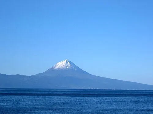
Mount Pico José Luís Ávila Silveira/Pedro Noronha e Costa · Public domain

Climate of Cabeço da Prainha
Best months for sightseeingBest months for sightseeing: June–July, October.
This month · November
A wet month
Day 20° · Night 15° · Rain 162 mm
- Hottest month
- August (day 27°)
- Coldest month
- February (night 12°)
- Wettest month
- January (191 mm)
- Driest month
- July (55 mm)
Bars: average monthly low and high temperature. Below: precipitation. Monthly averages for 1970–2000 at about 18 km resolution, adjusted for elevation. Highlighted months are mild and relatively dry. Source: WorldClim 2.1 (CC BY 4.0).
Show values as a table
| Month | Jan | Feb | Mar | Apr | May | Jun | Jul | Aug | Sep | Oct | Nov | Dec |
|---|---|---|---|---|---|---|---|---|---|---|---|---|
| Average high (°C) | 18° | 17° | 18° | 19° | 21° | 23° | 26° | 27° | 26° | 23° | 20° | 19° |
| Average low (°C) | 13° | 12° | 13° | 13° | 15° | 17° | 19° | 20° | 19° | 17° | 15° | 14° |
| Precipitation (mm) | 191 | 147 | 142 | 108 | 93 | 65 | 55 | 75 | 116 | 151 | 162 | 177 |
How to get to Cabeço da Prainha
The nearest airport is Pico Airport (PIX), 14 km to the north as the crow flies.
Airports
- Pico Airport (PIX) Pico Island 14 kmnorth
- Horta Airport (HOR) Horta 26 kmwest
- São Jorge Airport (SJZ) Velas 34 kmnortheast
Straight-line distances; road distances are longer. Airport data: OurAirports.
Day trips from Cabeço da Prainha
Within 100 km: 1 historic or cultural site, 117 natural sites, 7 lakes, rivers and coasts.
0–25 km96 places
- Cabeço da Rocha Mountain 15 kmE
- Cabeço do Moiro Mountain 10 kmE
- Cabeço da Cruz Mountain 12 kmNE
- Cabeço Negro Mountain 14 kmE
25–60 km26 places
- Cabeço Silvado Mountain 29 kmE
- Castelete Mountain 34 kmE
- Cabeço das Cabras Mountain 27 kmE
- Cabeço das Cruzes Mountain 32 kmE
60–100 km3 places
- Serra das Fontes Mountain 78 kmNE
- Serra da Dormida Mountain 76 kmNE
- Facho Mountain 80 kmNE
Straight-line distances.
Nearest towns and villages
-
São Mateus Municipality, Madalena Municipality1.7 km NW
-
Candelária Municipality, Madalena Municipality5.4 km NW
-
São João Municipality, Lajes do Pico Municipality7.3 km E
-
Criação Velha Municipality, Madalena Municipality8.5 km NW
-
Madalena Municipality, Madalena Municipality9.4 km N
-
Bandeiras Municipality, Madalena Municipality9.3 km N
Nearby attractions & nature
Everything nearby-
Cabeço de São Mateus Mountain, São Mateus0.6 km W
-
Ilhéu Redondo Island, Azores1.7 km SW
-
Ilhéu do Boi Island, Azores1.9 km W
-
Mount Pico Mountain, São Caetano5.2 km NE
-
Caldeiroes Mountain, São Mateus3.7 km NW
-
Ilhéu das Mocas Island, São Mateus3.3 km W
-
Selado Mountain, Candelária4.3 km NW
-
Cabeço do Manuel da Costa Mountain, São Mateus4.4 km W
Sources & licences
Data last updated: · 2 independent sources