Viana do Alentejo
Located in Viana do Alentejo Municipality, Évora District Coordinates: 38°20′31″ N 8°00′36″ W
- Population
- 2,528
- 2.5K
- Elevation
- 227 m
- above sea level
- Local time
- UTC+00:00
- Europe/Lisbon · UTC+00:00
- Places inside
- 1
- listed under Viana do Alentejo
- Airports
- LIS Lisbon Humberto Delgado Airport110 km
- BJZ Badajoz Airport120 km
About Viana do Alentejo
Viana do Alentejo is a municipality. Location: Viana do Alentejo Municipality, Évora District. Population: 2,528. Elevation: 227 m. The best months to visit are May, October. The nearest airport is Lisbon Humberto Delgado Airport (110 km). Nearby sights include Serra de Vila Nova and Monte de Santa Luzia.
Photos of Viana do Alentejo
-
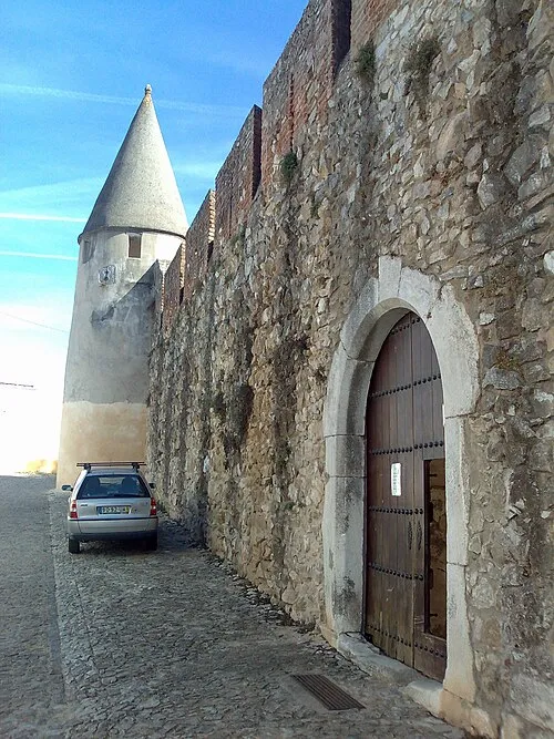
Castle of Viana do Alentejo Tagido · Public domain

Climate of Viana do Alentejo
Best months for sightseeingBest months for sightseeing: May, October.
This month · November
Outside the best season
Day 18° · Night 9° · Rain 81 mm
- Hottest month
- August (day 32°)
- Coldest month
- January (night 5°)
- Wettest month
- December (102 mm)
- Driest month
- July (4 mm)
Bars: average monthly low and high temperature. Below: precipitation. Monthly averages for 1970–2000 at about 18 km resolution, adjusted for elevation. Highlighted months are mild and relatively dry. Source: WorldClim 2.1 (CC BY 4.0).
Show values as a table
| Month | Jan | Feb | Mar | Apr | May | Jun | Jul | Aug | Sep | Oct | Nov | Dec |
|---|---|---|---|---|---|---|---|---|---|---|---|---|
| Average high (°C) | 14° | 15° | 18° | 19° | 23° | 28° | 31° | 32° | 28° | 23° | 18° | 14° |
| Average low (°C) | 5° | 6° | 7° | 8° | 10° | 13° | 15° | 15° | 14° | 12° | 9° | 6° |
| Precipitation (mm) | 87 | 68 | 47 | 59 | 49 | 20 | 4 | 5 | 27 | 67 | 81 | 102 |
How to get to Viana do Alentejo
The nearest airport is Lisbon Humberto Delgado Airport (LIS), 110 km to the northwest as the crow flies. The nearest large city is Setúbal, 79 km to the west.
Airports
- Lisbon Humberto Delgado Airport (LIS) Lisbon 110 kmnorthwest
- Badajoz Airport (BJZ) Badajoz 120 kmnortheast
- Cascais Airport (CAT) Cascais 125 kmwest
Nearby large cities
- Setúbal Population: 118.2K 79 kmwest
- Lisbon Population: 517.8K 108 kmnorthwest
- Badajoz Population: 150.5K 108 kmnortheast
- Huelva Population: 144.3K 152 kmsoutheast
- Seville Population: 686.7K 208 kmsoutheast
Straight-line distances; road distances are longer. Airport data: OurAirports.
Day trips from Viana do Alentejo
Within 100 km: 28 historic and cultural sites, 108 natural sites, 41 lakes, rivers and coasts.
0–25 km8 places
- Alto da Saudade Mountain 10 kmNW
- Jogo da Bola Mountain 22 kmNW
- Barroqueiras Mountain 11 kmNW
- Serra de Vila Nova Mountain 8 kmS
25–60 km39 places
- Vale do Corvo Natural site 53 kmNW
- Vale da Venda Natural site 57 kmN
- Vale do Simarro Natural site 58 kmNW
- Vale do Porco Natural site 58 kmNW
60–100 km130 places
- Castelo de Estremoz Historic site 66 kmNE
- Vale do Sesmo Natural site 60 kmNW
- Vale do Gavião Natural site 63 kmNW
- Vale Fortunato Natural site 65 kmNW
Straight-line distances.
Places in Viana do Alentejo
1 placeNearby attractions & nature
Everything nearby-
Serra de Vila Nova Mountain, Vila Nova da Baronia8 km S
-
Monte de Santa Luzia Mountain, Alvito9.8 km S
-
Alto da Saudade Mountain, União das freguesias de Nossa Senhora da Tourega e Nossa Senhora de Guadalupe10 km NW
-
Barroqueiras Mountain, União das freguesias de Nossa Senhora da Tourega e Nossa Senhora de Guadalupe11 km NW
-
Outeiro do Salto Mountain, Torre de Coelheiros15 km NE
-
Fontainhas Mountain, União das freguesias de Nossa Senhora da Tourega e Nossa Senhora de Guadalupe22 km N
-
Jogo da Bola Mountain, Alcáçovas22 km NW
Sources & licences
Data last updated: