- Elevation
- 1,476 m
- above sea level
- Local time
- UTC+03:00
- Europe/Istanbul · UTC+03:00
- Airports
- MSR Muş Airport22 km
- BAL Batman Airport81 km
About Özenli
Özenli is a village. Location: Mutki İlçesi, Bitlis Province. Elevation: 1,476 m. The best months to visit are May–June, September–October. The nearest airport is Muş Airport (22 km). Nearby sights include Aghperig Monastery and Çayır Dağı.
Photos of Özenli
-
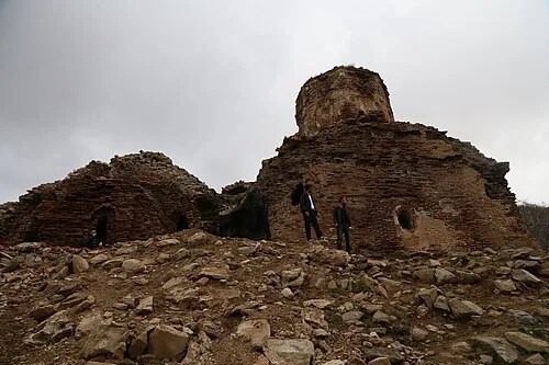
Aghperig Monastery Jwslubbock · CC BY-SA 4.0

Climate of Özenli
Best months for sightseeingBest months for sightseeing: May–June, September–October.
This month · November
A wet month
Day 11° · Night 2° · Rain 112 mm
Better nearby cities in November
- Cizre · 147 km south20°
- Silopi · 165 km southeast20°
- Kızıltepe · 176 km southwest19°
- Hottest month
- August (day 32°)
- Coldest month
- January (night -7°)
- Wettest month
- April (136 mm)
- Driest month
- August (7 mm)
Bars: average monthly low and high temperature. Below: precipitation. Monthly averages for 1970–2000 at about 18 km resolution, adjusted for elevation. Highlighted months are mild and relatively dry. Source: WorldClim 2.1 (CC BY 4.0).
Show values as a table
| Month | Jan | Feb | Mar | Apr | May | Jun | Jul | Aug | Sep | Oct | Nov | Dec |
|---|---|---|---|---|---|---|---|---|---|---|---|---|
| Average high (°C) | 1° | 2° | 6° | 13° | 20° | 26° | 31° | 32° | 27° | 19° | 11° | 4° |
| Average low (°C) | -7° | -6° | -1° | 4° | 9° | 13° | 17° | 17° | 13° | 8° | 2° | -3° |
| Precipitation (mm) | 100 | 110 | 115 | 136 | 87 | 27 | 8 | 7 | 14 | 78 | 112 | 112 |
Other places to visit in this season: May June September October
How to get to Özenli
The nearest airport is Muş Airport (MSR), 22 km to the north as the crow flies. The nearest large city is Siirt, 77 km to the southeast.
Airports
- Muş Airport (MSR) Muş 22 kmnorth
- Batman Airport (BAL) Batman 81 kmsouthwest
- Bingöl Airport (BGG) Bingöl 92 kmwest
Nearby large cities
- Siirt Population: 114K 77 kmsoutheast
- Batman Population: 452.2K 84 kmsouthwest
- Bingoel Population: 128.9K 101 kmwest
- Diyarbakır Population: 1.8M 140 kmsouthwest
- Cizre Population: 134K 146 kmsouth
Straight-line distances; road distances are longer. Airport data: OurAirports.
Day trips from Özenli
Within 100 km: 113 historic and cultural sites, 859 natural sites, 418 lakes, rivers and coasts.
0–25 km32 places
- Meydan Dağı Mountain 22 kmSW
- Kuşçudağı Tepe Mountain 8 kmSE
- Kurtik Dağı Mountain 16 kmNW
- Kazka Dağı Mountain 24 kmNW
25–60 km140 places
- Lake Nemrut Lake 56 kmE
- Batman Barajı Lake 55 kmSW
- Garzan Barajı Lake 32 kmS
- Nilüfer Gölü Lake 57 kmN
60–100 km1,218 places
- Demirkaya Historic site 88 kmS
- Simhaç Adası Island 93 kmE
- Seki Gölü Lake 75 kmN
- Lake Nazik Lake 70 kmNE
Straight-line distances.
Nearby attractions & nature
Everything nearby-
Aghperig Monastery Attraction, Mutki İlçesi2.5 km NE
-
Çayır Dağı Mountain, Mutki İlçesi3.6 km N
-
Haçreş Dağları Mountain, Muş Province8.6 km N
-
Kuşçudağı Tepe Mountain, Batman Province7.9 km SE
-
Hindanik Deresi River, Bitlis Province8.1 km E
-
Subaşıdağı Tepe Mountain, Batman Province11 km SW
Sources & licences
Data last updated: