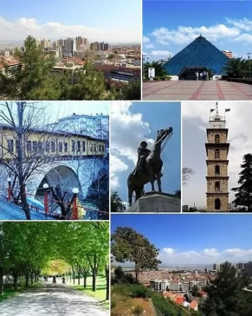
- Population
- 3,194,720
- 3.2M
- Elevation
- 1,372 m
- above sea level
- Local time
- UTC+03:00
- Europe/Istanbul · UTC+03:00
- Places inside
- 164
- listed under Bursa Province
- Airports
- YEI Bursa Yenişehir Airport37 km
- SAW Istanbul Sabiha Gökçen International Airport85 km
About Bursa Province
Bursa Province is a region. Location: Turkey. Population: 3,194,720.
Bursa is a city in northwestern Turkey and the administrative center of Bursa Province. It is the fourth-most populous city in Turkey and second-most populous in the Marmara Region after Istanbul. According to 2025 end of year estimate, the province has a population of 3,263,011 while Bursa city has a population of around 2.5 million. Bursa is one of the centers of Turkey's automotive production, becoming an industrial center of the country. The city provides various places of interest.
Source: Wikipedia · CC BY-SA 4.0
Photos of Bursa Province
-
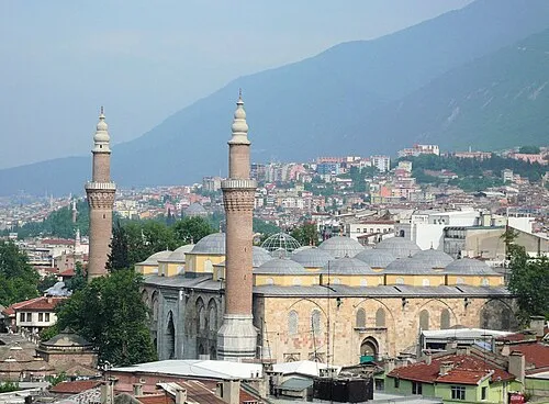
Bursa Grand Mosque Beñat Irasuegi · CC BY-SA 4.0 -
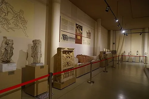
Bursa Archaeological Museum Canercangul · CC BY-SA 4.0


Travel notes for Bursa Province
From Wikivoyage
Bursa Province is in northwestern Turkey.
It’s divided between the following regions:
Eastern Marmara (Iznik)
Southern Marmara (Bursa (the provincial capital), Gemlik)
Source: Wikivoyage · CC BY-SA 4.0 · abridged
Twin towns and sister cities of Bursa Province
- Oulu· Finland
- Sofia· Bulgaria
- Plovdiv· Bulgaria
- Košice· Slovakia
Source: Wikidata. Only places with a page on this site are shown.
Population of Bursa Province over time
| 1955 | 128,875 | |
|---|---|---|
| 1980 | 487,604 | |
| 2000 | 1,184,144 | |
| 2015 | 1,854,285 | |
| 2016 | 2,901,396 | |
| 2018 | 2,994,521 |
Censuses and official estimates; source: Wikidata.
Climate of Bursa Province
Best months for sightseeingBest months for sightseeing: June–September.
This month · November
A cold month
Day 9° · Night 0° · Rain 80 mm
Better nearby cities in November
- Aydin · 280 km southwest19°
- Hottest month
- August (day 22°)
- Coldest month
- January (night -5°)
- Wettest month
- December (107 mm)
- Driest month
- August (17 mm)
Bars: average monthly low and high temperature. Below: precipitation. Monthly averages for 1970–2000 at about 18 km resolution, adjusted for elevation. Highlighted months are mild and relatively dry. Source: WorldClim 2.1 (CC BY 4.0).
Show values as a table
| Month | Jan | Feb | Mar | Apr | May | Jun | Jul | Aug | Sep | Oct | Nov | Dec |
|---|---|---|---|---|---|---|---|---|---|---|---|---|
| Average high (°C) | 2° | 3° | 6° | 11° | 16° | 20° | 22° | 22° | 19° | 14° | 9° | 4° |
| Average low (°C) | -5° | -4° | -3° | 1° | 5° | 8° | 10° | 10° | 7° | 4° | 0° | -3° |
| Precipitation (mm) | 97 | 78 | 70 | 71 | 62 | 40 | 19 | 17 | 26 | 48 | 80 | 107 |
Other places to visit in this season: June July August September
How to get to Bursa Province
The nearest airport is Bursa Yenişehir Airport (YEI), 37 km to the east as the crow flies. For international flights: Istanbul Sabiha Gökçen International Airport (SAW) (85 km). The nearest large city is Bursa, 10 km to the northwest.
Airports
- Bursa Yenişehir Airport (YEI) Yenişehir 37 kmeast
- Istanbul Sabiha Gökçen International Airport (SAW) Pendik, Istanbul 85 kmnorth
- Balıkesir Airport (BZI) Balıkesir 120 kmsouthwest
Nearby large cities
- Bursa Population: 3.1M 10 kmnorthwest
- Nilufer Population: 536.4K 22 kmwest
- İnegöl Population: 134K 31 kmeast
- Mustafakemalpaşa Population: 101.4K 65 kmwest
- Gebze Population: 281.4K 77 kmnorth
Straight-line distances; road distances are longer. Airport data: OurAirports.
Places in Bursa Province
164 places- 1 Osmangazi District 891.2K
- 2 Yıldırım İlçesi 637.9K
- 3 Nilüfer 358.3K
- 4 İnegöl 294.5K
- 5 Gemlik 120.2K
- 6 Mudanya District 108K
- 7 Gürsu 102.6K
- 8 Mustafakemalpaşa İlçesi 100K
- 9 Karacabey İlçesi 80.5K
- 10 Orhangazi İlçesi 75.7K
- 11 Yenişehir İlçesi 52.1K
- 12 Kestel İlçesi 51.9K
- 13 İznik İlçesi 43.3K
- 14 Orhaneli İlçesi 22.2K
- 15 Keles İlçesi 13.6K
- 16 Büyükorhan İlçesi 11.9K
- 17 Harmancık İlçesi 7.1K
Bar: population relative to the most populous place in this list.
Cities & villages5
- Büyük Orhan Bucağı · Municipality
- Çalı Bucağı · Municipality
- Çaltılıbük Bucağı · Municipality
- Demirtaş Bucağı · Municipality
- Devecikonağı Bucağı · Municipality
Mountains & nature3
- Alaçamormanları · Natural site
- Atatürk Kent Ormanı · Natural site
- Dikmen Tepesi · Mountain
Lakes, rivers & coasts35
- Akarca Deresi · River
- Akçasu Deresi · River
- Aksu Deresi · River
- Ana Dere · River
- Arapçiftliği Gölü · Lake
- Aras Deresi · River
- Asarlık Deresi · River
- Ayaklı Dere · River
- Aydoğdu Deresi · River
- Ayvalı Deresi · River
- Bayındır Deresi · River
- Bedre Deresi · River
- Bostanlı Deresi · River
- Büyük Dere · River
- Çaltık Deresi · River
- Çamlık Deresi · River
- Çapaz Çayı · River
- Çayköy Deresi · River
- Çiçekli Dere · River
- Çınarlı Deresi · River
- Çınarlı Deresi · River
- Çınarlık Deresi · River
- Dağ Deresi · River
- Dalyan Gölü · Lake
- Dedeler Deresi · River
- Değirmenboğazı Deresi · River
- Değirmen Deresi · River
- Değirmen Deresi · River
- Değirmen Deresi · River
- Deli Çay · River
- Demirtaş Deresi · River
- Deniz Deresi · River
- Derbent Deresi · River
- Dikmen Deresi · River
- Dombaycı Deresi · River
Largest cities and towns
Nature and heritage in Bursa Province
Sources & licences
Data last updated: · 2 independent sources