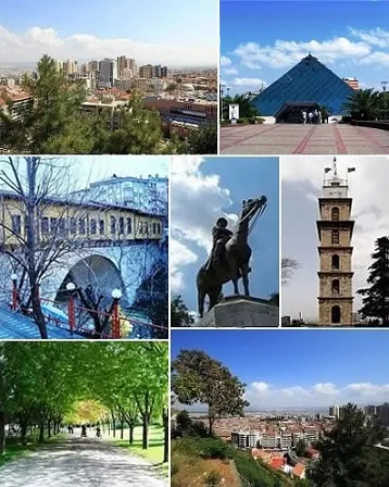
- Population
- 3,101,833
- 3.1M
- Elevation
- 155 m
- above sea level
- Local time
- UTC+03:00
- Europe/Istanbul · UTC+03:00
- Airports
- YEI Bursa Yenişehir Airport43 km
- SAW Istanbul Sabiha Gökçen International Airport81 km
About Bursa
Bursa is a city. Location: Osmangazi District, Bursa Province. Population: 3,101,833. Elevation: 155 m. The best months to visit are May, September–October. The nearest airport is Bursa Yenişehir Airport (43 km). Nearby sights include Bursa Grand Mosque and Bursa Archaeological Museum.
Photos of Bursa
-

Aerdemsenturk · CC BY-SA 4.0 -

Karakalem · CC BY-SA 4.0 -

AdamAppel · CC BY-SA 4.0 -

Basak · CC BY-SA 3.0 -

uğur baysan · CC BY-SA 3.0


Travel notes for Bursa
From Wikivoyage
Bursa is a large city in the Southern Marmara region of Turkey, 20 km inland from the Marmara coast. It's the country's fourth-largest city, with a population of 2,161,990 in 2021, and with another million living in the wider metro area. It's mostly modern, industrial and concrete-ridden; earning its living from textiles, agricultural produce and the automobile industry. However, it has a lot to offer for history buffs as the first capital of the Ottoman Empire and one of the end destinations of the Silk Road. It is crowded with historic mosques, tombs, caravanserais, bazaars and parks, in addition to being one of the best food cities in Western Turkey. In 2014, Bursa along with the nearby village of Cumalıkızık was added to the UNESCO World Heritage List. The city serves as a gateway to the iconic forests and ski slopes of Mount Uludağ.
Understand+
History:
Prusa, the kernel of present-day Bursa, was named for Prusias king of Bithynia, who laid its foundation stone in 202 BC. This was fortified into a walled citadel on the ridge of Tophane, controlling the valley trade routes. The Romans annexed Bithynia in 74 BC, and they especially enjoyed the thermal springs of Çekirge just west of Prusa - so it was a tourist resort even in those days. Byzantium (from 330 AD called Constantinople) became the metropolis of their eastern empire, continuing long after Rome itself fell.
By 1300 AD both the Byzantine Empire and their eastern rivals the Seljuks were in terminal decline, and a patchwork of independent territories and warlords appeared. One particularly successful leader was Osman, born in Söğüt around 1250. Next-to-nothing is reliably known about his life and works, it's all been mythologised and politicised in retrospect. He captured a series of small forts and towns but Prusa was a stout citadel, which he didn't have the technology or strategy to storm. Thus began a siege that (like that of Troy) may have lasted for ten years, and Osman died in 1323. His son Orhan captured the city in 1326, making it his capital Hüdavendigâr ("God's gift"). Over the following century the Ottoman dynasty went on to capture Thrace then make their move on Constantinople and found an empire. So Bursa always had a special place in their psyche and their sultans continued to be buried here.
Get in+
By plane:
International visitors usually arrive via one of the Istanbul airports. Sabiha Gökçen (SAW IATA) the Asia-side airport has many European and domestic flights. Burulaş Bus runs hourly to Bursa Otogar taking 90 min, single 70 TL. You're looking for the yellow bus outside Arrivals.
Istanbul Airport (IST IATA) is Europe-side. Its flight connections are global, but you'll have to travel into city centre to find a bus or ferry onward.
1 Yenişehir Airport (YEI IATA) (43 km east of city). Anadolu Jet fly to Bursa from the eastern cities of Trabzon, Diyarbakır, Erzurum and Muş, but in 2021 / 22 many flights are suspended. In any case, given the distance of the airport, and its poor connections with the city, it might be easier to fly to either of Istanbul's airports then take the bus or ferry onward. From YEI to town take Bus 80 to the city (6 TL, pay on boarding by cash or Bursakart). This runs to Kent Meydanı, for the Metro. (updated Jan 2022)
By train:
Bursa has no railway. A high-speed line is under construction and is due to open in 2023, but the project has been delayed several times.
Buses meet the YHT fast trains at Eskişehir then take two hours to Bursa. There are four connections a day with Ankara (journey time 4 hours), and two with Konya (for Karaman and Antalya). No point using this route for Istanbul as the ferry or direct bus is quicker.
2 Bursa railway station (Bursa Yüksek Hızlı Tren Garı). (updated Oct 2022)
By road:
From Istanbul follow E80 / O5 east, which sweeps round in an arc over Osmangazi Bridge then southwest. You could save some distance but no time by taking the ferry from Pendik to Yalova. O5 continues south to Balıkesir and İzmir.
From Ankara follow D200 / E90 via Eskişehir; this road continues along the coast to Bandırma and Çanakkale.
By bus:
Source: Wikivoyage · CC BY-SA 4.0 · abridged
Climate of Bursa
Best months for sightseeingBest months for sightseeing: May, September–October.
This month · November
Outside the best season
Day 15° · Night 5° · Rain 70 mm
Better nearby cities in November
- Aydin · 282 km south19°
- Hottest month
- July (day 30°)
- Coldest month
- January (night 1°)
- Wettest month
- December (82 mm)
- Driest month
- August (18 mm)
Bars: average monthly low and high temperature. Below: precipitation. Monthly averages for 1970–2000 at about 18 km resolution, adjusted for elevation. Highlighted months are mild and relatively dry. Source: WorldClim 2.1 (CC BY 4.0).
Show values as a table
| Month | Jan | Feb | Mar | Apr | May | Jun | Jul | Aug | Sep | Oct | Nov | Dec |
|---|---|---|---|---|---|---|---|---|---|---|---|---|
| Average high (°C) | 9° | 10° | 13° | 18° | 23° | 28° | 30° | 30° | 27° | 21° | 15° | 11° |
| Average low (°C) | 1° | 2° | 3° | 7° | 11° | 15° | 17° | 17° | 13° | 9° | 5° | 3° |
| Precipitation (mm) | 80 | 62 | 58 | 49 | 42 | 29 | 20 | 18 | 34 | 56 | 70 | 82 |
How to get to Bursa
The nearest airport is Bursa Yenişehir Airport (YEI), 43 km to the east as the crow flies. For international flights: Istanbul Sabiha Gökçen International Airport (SAW) (81 km). The nearest large city is Nilufer, 12 km to the west.
Airports
- Bursa Yenişehir Airport (YEI) Yenişehir 43 kmeast
- Istanbul Sabiha Gökçen International Airport (SAW) Pendik, Istanbul 81 kmnorth
- Balıkesir Airport (BZI) Balıkesir 116 kmsouthwest
Nearby large cities
- Nilufer Population: 536.4K 12 kmwest
- İnegöl Population: 134K 41 kmeast
- Mustafakemalpaşa Population: 101.4K 58 kmwest
- Gebze Population: 281.4K 74 kmnortheast
- Maltepe Population: 427K 83 kmnorth
Straight-line distances; road distances are longer. Airport data: OurAirports.
Day trips from Bursa
Within 100 km: 138 historic and cultural sites, 168 natural sites, 271 lakes, rivers and coasts.
0–25 km51 places
- Gölbaşı Göleti Lake 23 kmE
- Ulu Dağ Mountain 20 kmSE
- Mahya Tepesi Mountain 25 kmNE
- Kırbayır Tepesi Mountain 19 kmNE
25–60 km132 places
- Mutlu Adası Island 36 kmW
- İmralı Adası Island 59 kmNW
- Halilbey Adası Island 41 kmW
- Terzioğlu Adası Island 34 kmW
60–100 km394 places
- Yeniköy Plaj Beach 62 kmW
- Sedef Adası Island 87 kmW
- Andirovitha Island Island 73 kmN
- Pita Island Island 76 kmN
Straight-line distances.
Bursa and similar cities
Side by side with cities of similar size in the same country: population, elevation and climate.
| Measure | Bursa | Izmir | Ankara | Gaziantep |
|---|---|---|---|---|
| Population | 3.1M | 2.9M | 3.5M | 2.2M |
| Elevation | 155 m | 122 m | 850 m | 842 m |
| Summer day (hottest month) | 30° | 33° | 30° | 36° |
| Winter night (coldest month) | 1° | 5° | -4° | -2° |
| Annual rainfall | 600 mm | 679 mm | 400 mm | 532 mm |
| Best months | May, Sep–Oct | Apr–May, Oct | May–Jun, Sep–Oct | Apr–May, Oct |
| Distance | — | 258 km | 325 km | 804 km |
Climate values are 1970–2000 monthly averages; straight-line distance.
Nearby attractions & nature
Everything nearby-
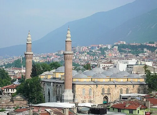 Bursa Grand Mosque Attraction, Osmangazi District1.3 km S
-
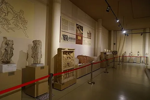 Bursa Archaeological Museum Museum, Osmangazi District1.7 km W
-
Bursa Atatürk Stadyumu Landmark, Osmangazi District1 km W
-
Kültür Parkı Natural site, Osmangazi District1.4 km W
-
Muradiye Complex Attraction, Osmangazi District1.3 km SW
-
Valilik Olimpik Atletizm Stadyumu Landmark, Osmangazi District2.3 km E
-
Bursa Hayvanat Bahçesi Attraction, Osmangazi District2.9 km NW
-
Bursa Botanik Parkı Natural site, Osmangazi District3.3 km NW
Sources & licences
Data last updated: