- Population
- 43,345
- 43.3K
- Elevation
- 34 m
- above sea level
- Local time
- UTC+03:00
- Europe/Istanbul · UTC+03:00
- Places inside
- 50
- listed under Gelibolu İlçesi
- Airports
- CKZ Çanakkale Airport40 km
- AXD Alexandroupoli Democritus Airport73 km
About Gelibolu İlçesi
Gelibolu İlçesi is a district. Location: Çanakkale Province, Turkey. Population: 43,345. The best months to visit are May–June, September–October. The nearest airport is Çanakkale Airport (40 km). Nearby sights include Bağçeşme Limanı and Kanak Oghlu Dere.
Photos of Gelibolu İlçesi
-
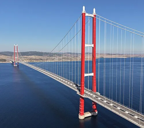
1915 Çanakkale Bridge Glabb · CC BY-SA 3.0

Climate of Gelibolu İlçesi
Best months for sightseeingBest months for sightseeing: May–June, September–October.
This month · November
Outside the best season
Day 15° · Night 8° · Rain 89 mm
Better nearby cities in November
- Aydin · 308 km south19°
- Hottest month
- July (day 29°)
- Coldest month
- January (night 3°)
- Wettest month
- December (106 mm)
- Driest month
- August (12 mm)
Bars: average monthly low and high temperature. Below: precipitation. Monthly averages for 1970–2000 at about 18 km resolution, adjusted for elevation. Highlighted months are mild and relatively dry. Source: WorldClim 2.1 (CC BY 4.0).
Show values as a table
| Month | Jan | Feb | Mar | Apr | May | Jun | Jul | Aug | Sep | Oct | Nov | Dec |
|---|---|---|---|---|---|---|---|---|---|---|---|---|
| Average high (°C) | 9° | 10° | 12° | 17° | 22° | 27° | 29° | 29° | 25° | 20° | 15° | 11° |
| Average low (°C) | 3° | 3° | 4° | 8° | 12° | 16° | 19° | 19° | 16° | 12° | 8° | 5° |
| Precipitation (mm) | 87 | 73 | 68 | 51 | 36 | 27 | 17 | 12 | 29 | 55 | 89 | 106 |
Other places to visit in this season: May June September October
How to get to Gelibolu İlçesi
The nearest airport is Çanakkale Airport (CKZ), 40 km to the southwest as the crow flies. For international flights: Balıkesir Koca Seyit Airport (EDO) (105 km). The nearest large city is Çanakkale, 39 km to the southwest.
Airports
- Çanakkale Airport (CKZ) Çanakkale 40 kmsouthwest
- Alexandroupoli Democritus Airport (AXD) Alexandroupolis 73 kmnorthwest
- Balıkesir Koca Seyit Airport (EDO) Edremit 105 kmsouth
Nearby large cities
- Çanakkale Population: 143.6K 39 kmsouthwest
- Tekirdağ Population: 122.3K 93 kmnortheast
- Bandırma Population: 107.6K 114 kmeast
- Çorlu Population: 202.6K 125 kmnortheast
- Edirne Population: 180K 136 kmnorth
Straight-line distances; road distances are longer. Airport data: OurAirports.
Day trips from Gelibolu İlçesi
Within 100 km: 61 historic and cultural sites, 240 natural sites, 304 lakes, rivers and coasts.
0–25 km66 places
- Mınıkada Island 21 kmNE
- Xeros Islands Island 20 kmNE
- Küçükada Island 21 kmNE
- Büyükada Island 20 kmNE
25–60 km249 places
- S Beach Beach 58 kmSW
- X Beach Beach 59 kmSW
- Gully Beach Beach 57 kmSW
- Camber Beach Beach 60 kmSW
60–100 km290 places
- W Beach Beach 61 kmSW
- V Beach Beach 60 kmSW
- Mavro Island Island 76 kmSW
- Karayer Adaları Island 76 kmSW
Straight-line distances.
Places in Gelibolu İlçesi
50 placesBar: population relative to the most populous place in this list.
Cities & villages32
- Adilhan · Village
- Bayırköy · Village
- Bayramiç · Village
- Burhanlı · Village
- Cevizli · Village
- Çokal · Village
- Cumalı · Village
- Değirmendüzü · Village
- Demirtepe · Village
- Dirikköy · Village
- Evreşe · Village
- Fındıklı · Village
- Güneyli · Village
- Ilgardere · Village
- Kalealtı · Village
- Karainebeyli · Village
- Kavakköy · Village
- Kavaklı · Village
- Kocaçeşme · Village
- Koruköy · Village
- Krithote · Village
- Münip Çiftliği · Village
- Ocaklı · Village
- Ortaköy · Village
- Pazarlı · Village
- Şadıllı · Village
- Şehitlik · Village
- Süleymaniye · Village
- Sütlüce · Village
- Tayfurköy · Village
- Yeniköy · Village
- Yülüce · Village
Mountains & nature10
- Bakla Tepesi · Mountain
- Derbend Tepe · Mountain
- Eşekçi Dağı · Mountain
- Kaba Tepe · Mountain
- Kanal Tepesi · Mountain
- Karaghol Tepe · Mountain
- Maslak Tepesi · Mountain
- Üre Dağı · Mountain
- Yassı Tepe · Mountain
- Zor Dağ · Mountain
Heritage & sights6
- 1915 Çanakkale Bridge · Landmark
- Fort Napoleon (historical) · Historic site
- Fort Sultan (historical) · Historic site
- Fort Victoria (historical) · Historic site
- Gallipoli Lighthouse · Landmark
- Megola Dabba Battery (historical) · Historic site
Nearby attractions & nature
Everything nearby-
Bağçeşme Limanı Natural site, Çanakkale Province5.4 km SE
-
Kanak Oghlu Dere River, Çanakkale Province5.8 km N
-
Harji Dere River, Çanakkale Province6 km N
-
Kainarja River, Çanakkale Province6.1 km N
-
Gelibolu Limanı Natural site, Çanakkale Province6.2 km S
-
Yenikli Bay Natural site, Çanakkale Province8.2 km NE
Sources & licences
Data last updated: