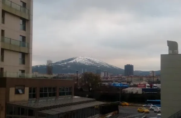
- Elevation
- 426 m
- above sea level
- Local time
- UTC+03:00
- Europe/Istanbul · UTC+03:00
- Airports
- SAW Istanbul Sabiha Gökçen International Airport15 km
- IST İstanbul Airport50 km
About Kayış Dağı
Kayış Dağı is a mountain. Location: Maltepe, Istanbul. Elevation: 426 m.
Mount Auxentius (also known as Mount St. Auxentius, Mount Auxentios, or Mount Scopas), today known as Kayış Dağı in Turkish, is a mountain located in the eastern outskirts of Istanbul, Turkey, in Kayışdağı neighborhood. Its summit is 428 metres above sea level. The mountain is named after Auxentius of Bithynia. The mountain was home to Christian monks and ascetics during the Byzantine period. Byzantine Christian monks who lived on the mountain included Saint Stephen the New (c.
Source: Wikipedia · CC BY-SA 4.0
Photos of Kayış Dağı
-

Mikhail Malykh · CC BY 3.0 -

Artemco · CC BY-SA 4.0 -

Mikhail Malykh · CC BY 3.0


Climate of Kayış Dağı
Best months for sightseeingBest months for sightseeing: June–September.
This month · November
Outside the best season
Day 12° · Night 6° · Rain 87 mm
Better nearby cities in November
- Aydin · 366 km south19°
- Hottest month
- July (day 26°)
- Coldest month
- February (night 1°)
- Wettest month
- December (111 mm)
- Driest month
- July (26 mm)
Bars: average monthly low and high temperature. Below: precipitation. Monthly averages for 1970–2000 at about 18 km resolution, adjusted for elevation. Highlighted months are mild and relatively dry. Source: WorldClim 2.1 (CC BY 4.0).
Show values as a table
| Month | Jan | Feb | Mar | Apr | May | Jun | Jul | Aug | Sep | Oct | Nov | Dec |
|---|---|---|---|---|---|---|---|---|---|---|---|---|
| Average high (°C) | 6° | 7° | 9° | 14° | 19° | 24° | 26° | 25° | 22° | 17° | 12° | 8° |
| Average low (°C) | 1° | 1° | 2° | 6° | 10° | 14° | 16° | 16° | 13° | 10° | 6° | 3° |
| Precipitation (mm) | 93 | 67 | 64 | 48 | 37 | 30 | 26 | 33 | 43 | 78 | 87 | 111 |
Other places to visit in this season: June July August September
How to get to Kayış Dağı
The nearest airport is Istanbul Sabiha Gökçen International Airport (SAW), 15 km to the southeast as the crow flies. The nearest large city is Maltepe, 4 km to the south.
Airports
- Istanbul Sabiha Gökçen International Airport (SAW) Pendik, Istanbul 15 kmsoutheast
- İstanbul Airport (IST) Istanbul 50 kmnorthwest
- Bursa Yenişehir Airport (YEI) Yenişehir 86 kmsoutheast
Nearby large cities
- Maltepe Population: 427K 4 kmsouth
- Ataşehir Population: 361.6K 4 kmwest
- Ümraniye Population: 573.3K 6 kmnorthwest
- Sancaktepe Population: 489.8K 7 kmnortheast
- Sultanbeyli Population: 358.2K 9 kmeast
Straight-line distances; road distances are longer. Airport data: OurAirports.
Day trips from Kayış Dağı
Within 100 km: 156 historic and cultural sites, 154 natural sites, 244 lakes, rivers and coasts.
0–25 km165 places
- Andirovitha Island Island 13 kmS
- Pita Island Island 12 kmSW
- Princes Islands Island 12 kmSW
- Proti Island Island 12 kmSW
25–60 km168 places
- Karaburun Plajı Beach 56 kmNW
- Karaburun Sahili Plaj Beach 59 kmNW
- Yeniköy Plajı Beach 54 kmNW
- Kara Burun Plaji Beach 57 kmNW
60–100 km221 places
- Yeniköy Plaj Beach 92 kmSW
- Kefken Adası Island 96 kmE
- İmralı Adası Island 72 kmSW
- Terzioğlu Adası Island 99 kmSW
Straight-line distances.
Nearest towns and villages
Nearby attractions & nature
Everything nearby-
Bakır Dağı Mountain, Ümraniye3.6 km NE
-
Tema Nezahat Gokyigit Park Natural site, Ümraniye4.8 km NW
-
Aydos Dağı Mountain, Pendik8.9 km SE
-
Taşdelen Memba Suyu River, Istanbul7.6 km N
-
Çatal Tepe Mountain, Sancaktepe13 km NE
-
Mezarlık Deresi River, Istanbul8 km E
-
Kalamış Koyu Natural site, Istanbul11 km W
-
Damatrys Palace / Samandira Summer Palace Historic site, Sancaktepe5.6 km E
Sources & licences
Data last updated: · 2 independent sources