Azdavay Bucağı
Located in Kastamonu Province, Turkey Coordinates: 41°38′26″ N 33°18′01″ E
- Elevation
- 827 m
- above sea level
- Local time
- UTC+03:00
- Europe/Istanbul · UTC+03:00
- Airports
- KFS Kastamonu Airport55 km
- ONQ Zonguldak Çaycuma Airport102 km
About Azdavay Bucağı
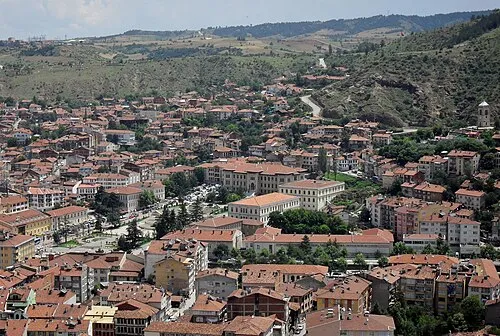
Azdavay Bucağı is a municipality. Location: Kastamonu Province, Turkey. Elevation: 827 m. The best months to visit are June–September. The nearest airport is Kastamonu Airport (55 km). Nearby sights include Yumacık Çayı and Darboğaz Çayı.
Climate of Azdavay Bucağı
Best months for sightseeingBest months for sightseeing: June–September.
This month · November
A cold month
Day 10° · Night 1° · Rain 54 mm
- Hottest month
- July (day 26°)
- Coldest month
- January (night -4°)
- Wettest month
- May (81 mm)
- Driest month
- September (33 mm)
Bars: average monthly low and high temperature. Below: precipitation. Monthly averages for 1970–2000 at about 18 km resolution, adjusted for elevation. Highlighted months are mild and relatively dry. Source: WorldClim 2.1 (CC BY 4.0).
Show values as a table
| Month | Jan | Feb | Mar | Apr | May | Jun | Jul | Aug | Sep | Oct | Nov | Dec |
|---|---|---|---|---|---|---|---|---|---|---|---|---|
| Average high (°C) | 2° | 4° | 9° | 15° | 19° | 23° | 26° | 25° | 22° | 16° | 10° | 4° |
| Average low (°C) | -4° | -3° | -1° | 4° | 8° | 11° | 13° | 12° | 9° | 6° | 1° | -2° |
| Precipitation (mm) | 63 | 51 | 53 | 67 | 81 | 61 | 43 | 39 | 33 | 49 | 54 | 73 |
Other places to visit in this season: June July August September
How to get to Azdavay Bucağı
The nearest airport is Kastamonu Airport (KFS), 55 km to the southeast as the crow flies. The nearest large city is Kastamonu, 49 km to the southeast.
Airports
- Kastamonu Airport (KFS) Kastamonu 55 kmsoutheast
- Zonguldak Çaycuma Airport (ONQ) Zonguldak 102 kmwest
- Sinop Airport (NOP) Sinop 153 kmeast
Nearby large cities
- Kastamonu Population: 125.6K 49 kmsoutheast
- Karabük Population: 125.4K 74 kmsouthwest
- Zonguldak Population: 101.7K 127 kmwest
- Bolu Population: 184.7K 174 kmsouthwest
- Çorum Population: 269.6K 184 kmsoutheast
Straight-line distances; road distances are longer. Airport data: OurAirports.
Day trips from Azdavay Bucağı
Within 100 km: 7 historic and cultural sites, 248 natural sites, 169 lakes, rivers and coasts.
0–25 km41 places
- Zeytinlik Tepesi Mountain 21 kmNW
- Sivritürbe Tepesi Mountain 8 kmW
- Kömürocağı Tepesi Mountain 16 kmSW
- Karyatağı Dağı Mountain 8 kmNE
25–60 km129 places
- Terzili Göleti Lake 47 kmE
- Çiğdem Barajı Lake 48 kmE
- Ulutepe Mountain 25 kmNW
- Tepe Dağı Mountain 48 kmSW
60–100 km254 places
- Büyük Ada Island 77 kmW
- Büyük Göl Lake 91 kmS
- Küçüksu Göleti Lake 78 kmE
- Zindan Dağı Mountain 94 kmE
Straight-line distances.
Nearby attractions & nature
Everything nearby-
Yumacık Çayı River, Kastamonu Province1 km E
-
Darboğaz Çayı River, Kastamonu Province4.2 km SW
-
Çal Tepesi Mountain, Azdavay İlçesi4.8 km NW
-
Sakarçal Tepesi Mountain, Azdavay İlçesi4.8 km E
-
Akçay River, Kastamonu Province7.3 km NW
-
Gözkayası Tepesi Mountain, Azdavay İlçesi7.2 km SW
-
Yukarı Dağ Mountain, Kastamonu Province12 km SW
-
Karyatağı Dağı Mountain, Azdavay İlçesi7.5 km NE
Other cities and towns in Kastamonu Province
-
Pınarbaşı City, Pınarbaşı İlçesi16 km W
-
Pınarbaşı Bucağı Municipality, Kastamonu Province17 km W
-
 Kastamonu City, Cide49 km SE
-
Daday City, Daday İlçesi23 km SE
-
Şenpazar Bucağı Municipality, Kastamonu Province21 km N
-
Ağlı Bucağı Municipality, Kastamonu Province22 km E
Sources & licences
Data last updated: