- Elevation
- 187 m
- above sea level
- Local time
- UTC+03:00
- Europe/Istanbul · UTC+03:00
- Airports
- DLM Dalaman International Airport46 km
- RHO Rhodes International Airport "Diagoras"112 km
About Çiller
Çiller is a village. Location: Seydikemer, Muğla Province. Elevation: 187 m. The best months to visit are April–May, October–November. The nearest airport is Dalaman International Airport (46 km). Nearby sights include Kıncılar Çayı and Tlos.
Climate of Çiller
Best months for sightseeingBest months for sightseeing: April–May, October–November.
This month · November
A good month to visit
Day 20° · Night 10° · Rain 95 mm
- Hottest month
- July (day 35°)
- Coldest month
- January (night 6°)
- Wettest month
- December (165 mm)
- Driest month
- August (6 mm)
Bars: average monthly low and high temperature. Below: precipitation. Monthly averages for 1970–2000 at about 18 km resolution, adjusted for elevation. Highlighted months are mild and relatively dry. Source: WorldClim 2.1 (CC BY 4.0).
Show values as a table
| Month | Jan | Feb | Mar | Apr | May | Jun | Jul | Aug | Sep | Oct | Nov | Dec |
|---|---|---|---|---|---|---|---|---|---|---|---|---|
| Average high (°C) | 14° | 15° | 18° | 22° | 26° | 32° | 35° | 34° | 31° | 26° | 20° | 16° |
| Average low (°C) | 6° | 6° | 8° | 11° | 15° | 19° | 22° | 22° | 18° | 14° | 10° | 7° |
| Precipitation (mm) | 162 | 124 | 78 | 42 | 29 | 14 | 8 | 6 | 16 | 57 | 95 | 165 |
Other places to visit in this season: April May October November
How to get to Çiller
The nearest airport is Dalaman International Airport (DLM), 46 km to the west as the crow flies. The nearest large city is Denizli, 127 km to the north.
Airports
- Dalaman International Airport (DLM) Dalaman 46 kmwest
- Rhodes International Airport "Diagoras" (RHO) Rhodes 112 kmwest
- Çardak Airport (DNZ) Denizli 132 kmnorth
Nearby large cities
- Denizli Population: 313.2K 127 kmnorth
- Antalya Population: 1.3M 128 kmeast
- Merkezefendi Population: 280.3K 131 kmnorth
- Muratpaşa Population: 450K 133 kmeast
- Nazilli Population: 119.4K 166 kmnorthwest
Straight-line distances; road distances are longer. Airport data: OurAirports.
Day trips from Çiller
Within 100 km: 25 historic and cultural sites, 330 natural sites, 234 lakes, rivers and coasts.
0–25 km50 places
- Çalış Beach Beach 18 kmW
- Ölüdeniz Plajı Beach 19 kmSW
- Kidrak Beach Beach 20 kmSW
- Kazil Islands Island 24 kmW
25–60 km200 places
- Kabak Beach Beach 26 kmSW
- Stavro Islands Island 34 kmW
- Öksüz Adası Island 53 kmS
- Tersaneh Island Island 34 kmW
60–100 km339 places
- Uzunyalı Plajı Beach 96 kmW
- Sarıada Island 65 kmSE
- Kekova Adası Island 73 kmSE
- Güvercin Adası Island 86 kmSE
Straight-line distances.
Nearby attractions & nature
Everything nearby-
Kıncılar Çayı River, Muğla Province6.4 km SE
-
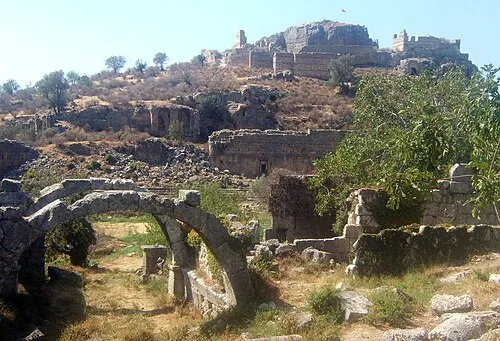 Tlos Historic site, Seydikemer15 km SE
-
Dolukızlan Tepesi Mountain, Fethiye12 km NW
-
Karadağ Tepesi Mountain, Seydikemer18 km E
-
Güney Dağı Mountain, Seydikemer19 km NE
-
Arı Dağı Mountain, Fethiye11 km SW
Sources & licences
Data last updated: