- Elevation
- 474 m
- above sea level
- Local time
- UTC+03:00
- Europe/Istanbul · UTC+03:00
- Airports
- DLM Dalaman International Airport46 km
- RHO Rhodes International Airport "Diagoras"104 km
About Dip
Dip is a village. Location: Seydikemer, Muğla Province. Elevation: 474 m. The best months to visit are April–May, October. The nearest airport is Dalaman International Airport (46 km). Nearby sights include Pinara and Baba Dağı.
Climate of Dip
Best months for sightseeingBest months for sightseeing: April–May, October.
This month · November
Outside the best season
Day 18° · Night 8° · Rain 95 mm
Better nearby cities in November
- Aydin · 193 km northwest19°
- Alanya · 246 km east21°
- Hottest month
- July (day 33°)
- Coldest month
- January (night 4°)
- Wettest month
- December (165 mm)
- Driest month
- August (6 mm)
Bars: average monthly low and high temperature. Below: precipitation. Monthly averages for 1970–2000 at about 18 km resolution, adjusted for elevation. Highlighted months are mild and relatively dry. Source: WorldClim 2.1 (CC BY 4.0).
Show values as a table
| Month | Jan | Feb | Mar | Apr | May | Jun | Jul | Aug | Sep | Oct | Nov | Dec |
|---|---|---|---|---|---|---|---|---|---|---|---|---|
| Average high (°C) | 13° | 13° | 16° | 20° | 25° | 30° | 33° | 33° | 29° | 24° | 18° | 14° |
| Average low (°C) | 4° | 5° | 6° | 9° | 13° | 17° | 20° | 20° | 17° | 12° | 8° | 6° |
| Precipitation (mm) | 162 | 124 | 78 | 42 | 29 | 14 | 8 | 6 | 16 | 57 | 95 | 165 |
How to get to Dip
The nearest airport is Dalaman International Airport (DLM), 46 km to the northwest as the crow flies. The nearest large city is Antalya, 137 km to the east.
Airports
- Dalaman International Airport (DLM) Dalaman 46 kmnorthwest
- Rhodes International Airport "Diagoras" (RHO) Rhodes 104 kmwest
- Antalya International Airport (AYT) Antalya 146 kmeast
Nearby large cities
- Antalya Population: 1.3M 137 kmeast
- Denizli Population: 313.2K 140 kmnorth
- Muratpaşa Population: 450K 142 kmeast
- Merkezefendi Population: 280.3K 144 kmnorth
- Nazilli Population: 119.4K 175 kmnorthwest
Straight-line distances; road distances are longer. Airport data: OurAirports.
Day trips from Dip
Within 100 km: 25 historic and cultural sites, 290 natural sites, 220 lakes, rivers and coasts.
0–25 km49 places
- Çalış Beach Beach 20 kmNW
- Ölüdeniz Plajı Beach 11 kmW
- Kidrak Beach Beach 10 kmW
- Kabak Beach Beach 12 kmSW
25–60 km171 places
- Stavro Islands Island 34 kmNW
- Öksüz Adası Island 42 kmSE
- Tersaneh Island Island 33 kmNW
- Sarıada Island 57 kmSE
60–100 km315 places
- Uzunyalı Plajı Beach 95 kmNW
- Kekova Adası Island 68 kmSE
- Güvercin Adası Island 86 kmE
- Bedir Adası Island 92 kmW
Straight-line distances.
Nearby attractions & nature
Everything nearby-
Pinara Historic site, Seydikemer3.7 km SE
-
Baba Dağı Mountain, Fethiye5.6 km W
-
Elmacık Dağı Mountain, Seydikemer8 km S
-
Arı Dağı Mountain, Fethiye8.2 km NW
-
Solak Sarnıcı Natural site, Muğla Province7.6 km NW
-
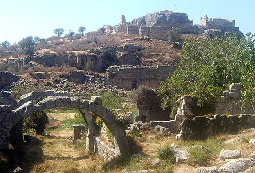 Tlos Historic site, Seydikemer16 km E
Sources & licences
Data last updated: