Dallıbahçe Bucağı
Located in Tunceli Province, Turkey Coordinates: 39°08′13″ N 39°53′05″ E
- Elevation
- 1,441 m
- above sea level
- Local time
- UTC+03:00
- Europe/Istanbul · UTC+03:00
- Airports
- BGG Bingöl Airport69 km
- ERC Erzincan Airport71 km
About Dallıbahçe Bucağı
Dallıbahçe Bucağı is a municipality. Location: Tunceli Province, Turkey. Elevation: 1,441 m. The best months to visit are May–June, September–October. The nearest airport is Bingöl Airport (69 km). Nearby sights include Serçe Deresi and Kalman Deresi.
Climate of Dallıbahçe Bucağı
Best months for sightseeingBest months for sightseeing: May–June, September–October.
This month · November
A wet month
Day 11° · Night 1° · Rain 102 mm
Better nearby cities in November
- Viranşehir · 213 km south18°
- Kızıltepe · 225 km south19°
- Suruç · 272 km southwest20°
- Hottest month
- July (day 32°)
- Coldest month
- January (night -7°)
- Wettest month
- December (125 mm)
- Driest month
- August (4 mm)
Bars: average monthly low and high temperature. Below: precipitation. Monthly averages for 1970–2000 at about 18 km resolution, adjusted for elevation. Highlighted months are mild and relatively dry. Source: WorldClim 2.1 (CC BY 4.0).
Show values as a table
| Month | Jan | Feb | Mar | Apr | May | Jun | Jul | Aug | Sep | Oct | Nov | Dec |
|---|---|---|---|---|---|---|---|---|---|---|---|---|
| Average high (°C) | 0° | 2° | 8° | 15° | 21° | 27° | 32° | 32° | 28° | 19° | 11° | 3° |
| Average low (°C) | -7° | -6° | -1° | 4° | 9° | 12° | 17° | 16° | 12° | 6° | 1° | -4° |
| Precipitation (mm) | 115 | 102 | 105 | 110 | 80 | 23 | 6 | 4 | 11 | 62 | 102 | 125 |
Other places to visit in this season: May June September October
How to get to Dallıbahçe Bucağı
The nearest airport is Bingöl Airport (BGG), 69 km to the southeast as the crow flies. The nearest large city is Bingoel, 60 km to the southeast.
Airports
- Bingöl Airport (BGG) Bingöl 69 kmsoutheast
- Erzincan Airport (ERC) Erzincan 71 kmnorthwest
- Elazığ Airport (EZS) Elazığ 79 kmsouthwest
Nearby large cities
- Bingoel Population: 128.9K 60 kmsoutheast
- Erzincan Population: 150.7K 75 kmnorthwest
- Elâzığ Population: 443.4K 77 kmsouthwest
- Diyarbakır Population: 1.8M 139 kmsouth
- Erzurum Population: 767.8K 147 kmnortheast
Straight-line distances; road distances are longer. Airport data: OurAirports.
Day trips from Dallıbahçe Bucağı
Within 100 km: 8 historic and cultural sites, 495 natural sites, 444 lakes, rivers and coasts.
0–25 km34 places
- Yeldağı Tepe Mountain 18 kmNW
- Küçükgöl Dağı Mountain 24 kmNW
- Kölerik Tepesi Mountain 21 kmSW
- Hadar Dağı Mountain 22 kmNE
25–60 km194 places
- Özlüce Barajı Lake 25 kmE
- Cayit Barajı Lake 40 kmE
- Ziri Dağı Mountain 37 kmSW
- Sulak Dağı Mountain 44 kmSW
60–100 km719 places
- Lake Hazar Lake 83 kmSW
- Keban Barajı Gölü Lake 64 kmSW
- Dipni Barajı Lake 82 kmSE
- Koç Gölü Lake 63 kmNW
Straight-line distances.
Nearby attractions & nature
Everything nearby-
Serçe Deresi River, Tunceli Province5.1 km S
-
Kalman Deresi River, Elazığ6.1 km S
-
Boncuk Dağı Mountain, Tunceli Province9 km NE
-
Tahkim Tepesi Mountain, Tunceli Province12 km NE
-
Sefer Deresi River, Elazığ8.6 km SE
-
Kıl Deresi River, Elazığ8.8 km S
-
Düzgünbaba Tepesi Mountain, Nazımiye İlçesi8.1 km W
-
Hayran Deresi River, Tunceli Province12 km S
Other cities and towns in Tunceli Province
-
Nazimiye Bucağı Municipality, Tunceli Province7.1 km NW
-
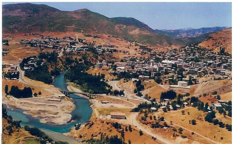 Tunceli City, Tunceli30 km W
-
Büyükyurt Bucağı Municipality, Tunceli Province12 km N
-
Kocakoç Bucağı Municipality, Tunceli Province20 km W
-
Darıkent Bucağı Municipality, Tunceli Province20 km S
-
Mazgirt City, Mazgirt İlçesi28 km SW
Sources & licences
Data last updated: