Kırmızıköprü Bucağı
Located in Tunceli Province, Turkey Coordinates: 39°23′32″ N 39°49′30″ E
- Elevation
- 1,250 m
- above sea level
- Local time
- UTC+03:00
- Europe/Istanbul · UTC+03:00
- Airports
- ERC Erzincan Airport44 km
- BGG Bingöl Airport89 km
About Kırmızıköprü Bucağı
Kırmızıköprü Bucağı is a municipality. Location: Tunceli Province, Turkey. Elevation: 1,250 m. The best months to visit are May–June, September–October. The nearest airport is Erzincan Airport (44 km). Nearby sights include Vanek Deresi and Sal Deresi.
Climate of Kırmızıköprü Bucağı
Best months for sightseeingBest months for sightseeing: May–June, September–October.
This month · November
A cold month
Day 12° · Night 3° · Rain 92 mm
Better nearby cities in November
- Viranşehir · 241 km south18°
- Kızıltepe · 254 km south19°
- Suruç · 295 km southwest20°
- Hottest month
- August (day 32°)
- Coldest month
- January (night -5°)
- Wettest month
- April (111 mm)
- Driest month
- August (8 mm)
Bars: average monthly low and high temperature. Below: precipitation. Monthly averages for 1970–2000 at about 18 km resolution, adjusted for elevation. Highlighted months are mild and relatively dry. Source: WorldClim 2.1 (CC BY 4.0).
Show values as a table
| Month | Jan | Feb | Mar | Apr | May | Jun | Jul | Aug | Sep | Oct | Nov | Dec |
|---|---|---|---|---|---|---|---|---|---|---|---|---|
| Average high (°C) | 3° | 4° | 8° | 15° | 21° | 27° | 32° | 32° | 28° | 20° | 12° | 5° |
| Average low (°C) | -5° | -4° | 1° | 7° | 11° | 14° | 18° | 18° | 14° | 9° | 3° | -2° |
| Precipitation (mm) | 85 | 79 | 86 | 111 | 97 | 36 | 10 | 8 | 16 | 67 | 92 | 101 |
Other places to visit in this season: May June September October
How to get to Kırmızıköprü Bucağı
The nearest airport is Erzincan Airport (ERC), 44 km to the northwest as the crow flies. The nearest large city is Erzincan, 48 km to the northwest.
Airports
- Erzincan Airport (ERC) Erzincan 44 kmnorthwest
- Bingöl Airport (BGG) Bingöl 89 kmsoutheast
- Elazığ Airport (EZS) Elazığ 100 kmsouthwest
Nearby large cities
- Erzincan Population: 150.7K 48 kmnorthwest
- Bingoel Population: 128.9K 81 kmsoutheast
- Elâzığ Population: 443.4K 95 kmsouthwest
- Erzurum Population: 767.8K 137 kmnortheast
- Diyarbakır Population: 1.8M 168 kmsouth
Straight-line distances; road distances are longer. Airport data: OurAirports.
Day trips from Kırmızıköprü Bucağı
Within 100 km: 8 historic and cultural sites, 671 natural sites, 489 lakes, rivers and coasts.
0–25 km37 places
- Yeldağı Tepe Mountain 22 kmSW
- Saban Dağı Mountain 21 kmE
- Oğulveren Tepesi Mountain 23 kmE
- Meryem Dağı Mountain 7 kmSW
25–60 km187 places
- Özlüce Barajı Lake 39 kmSE
- Cayit Barajı Lake 59 kmSE
- Koç Gölü Lake 47 kmW
- Yedi Göller Lake 45 kmN
60–100 km944 places
- Keban Barajı Gölü Lake 87 kmS
- Salyazı Barajı Lake 96 kmN
- Taşlı Göl Lake 88 kmE
- Büyük Göl Lake 88 kmE
Straight-line distances.
Nearby attractions & nature
Everything nearby-
Vanek Deresi River, Tunceli Province1.2 km SW
-
Sal Deresi River, Tunceli Province4.8 km SW
-
Acıelma Tepesi Mountain, Nazımiye İlçesi6.6 km S
-
Karagöz Deresi River, Tunceli Province7.5 km W
-
Meryem Dağı Mountain, Nazımiye İlçesi7.1 km SW
-
Sal Deresi River, Tunceli Province8.4 km W
-
Üsküle Deresi River, Tunceli Province8.7 km S
-
Karasakal Dağları Mountain, Tunceli Province16 km W
Other cities and towns in Tunceli Province
-
Pulumer City, Pülümür İlçesi12 km NE
-
Pülümür Bucağı Municipality, Tunceli Province12 km NE
-
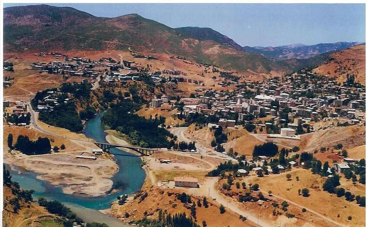 Tunceli City, Tunceli41 km SW
-
Büyükyurt Bucağı Municipality, Tunceli Province16 km S
-
Dağyolu Bucağı Municipality, Tunceli Province18 km NE
-
Nazimiye City, Nazımiye İlçesi24 km S
Sources & licences
Data last updated: