- Elevation
- 2,358 m
- above sea level
- Local time
- UTC+03:00
- Europe/Istanbul · UTC+03:00
- Airports
- YKO Hakkari Yüksekova Airport73 km
- VAN Van Ferit Melen Airport79 km
About Tokluca
Tokluca is a village. Location: Başkale İlçesi, Van Province. Elevation: 2,358 m. The best months to visit are June–September. The nearest airport is Hakkari Yüksekova Airport (73 km). Nearby sights include Art Tepe and Monastery of Saint Bartholomew.
Photos of Tokluca
-
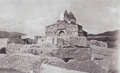
Monastery of Saint Bartholomew Unknown author Unknown author · Public domain

Climate of Tokluca
Best months for sightseeingBest months for sightseeing: June–September.
This month · November
A cold month
Day 7° · Night -3° · Rain 43 mm
Better nearby cities in November
- Silopi · 184 km southwest20°
- Cizre · 199 km southwest20°
- Kızıltepe · 335 km west19°
- Hottest month
- August (day 26°)
- Coldest month
- January (night -12°)
- Wettest month
- April (72 mm)
- Driest month
- September (9 mm)
Bars: average monthly low and high temperature. Below: precipitation. Monthly averages for 1970–2000 at about 18 km resolution, adjusted for elevation. Highlighted months are mild and relatively dry. Source: WorldClim 2.1 (CC BY 4.0).
Show values as a table
| Month | Jan | Feb | Mar | Apr | May | Jun | Jul | Aug | Sep | Oct | Nov | Dec |
|---|---|---|---|---|---|---|---|---|---|---|---|---|
| Average high (°C) | -3° | -2° | 3° | 10° | 16° | 21° | 26° | 26° | 23° | 15° | 7° | 0° |
| Average low (°C) | -12° | -11° | -6° | 0° | 4° | 8° | 13° | 12° | 8° | 2° | -3° | -9° |
| Precipitation (mm) | 38 | 42 | 59 | 72 | 57 | 27 | 13 | 10 | 9 | 44 | 43 | 43 |
Other places to visit in this season: June July August September
How to get to Tokluca
The nearest airport is Hakkari Yüksekova Airport (YKO), 73 km to the south as the crow flies. The nearest large city is Van, 76 km to the northwest.
Airports
- Hakkari Yüksekova Airport (YKO) Hakkari 73 kmsouth
- Van Ferit Melen Airport (VAN) Van 79 kmwest
- Urmia Airport (OMH) Urmia 99 kmsoutheast
Nearby large cities
- Van Population: 525K 76 kmnorthwest
- Silopi Population: 114.6K 184 kmsouthwest
- Iğdır Population: 101.7K 192 kmnorth
- Ağrı Population: 124.5K 194 kmnorthwest
- Siirt Population: 114K 198 kmwest
Straight-line distances; road distances are longer. Airport data: OurAirports.
Day trips from Tokluca
Within 100 km: 12 historic and cultural sites, 376 natural sites, 267 lakes, rivers and coasts.
0–25 km55 places
- Mirömer Dağı Mountain 21 kmNE
- Melik Tepesi Mountain 12 kmNW
- Keklik Dağı Mountain 23 kmW
- Başkale Dağı Mountain 24 kmSW
25–60 km182 places
- Yaylagöz Pınar Natural site 49 kmNW
- Turna Gölü Lake 57 kmNW
- Değirmi Gölü Lake 45 kmN
- Akgöl Lake 38 kmNW
60–100 km418 places
- Süphan Gölü Lake 89 kmN
- Hasantimur Gölü Lake 67 kmN
- Gövelek Gölü Lake 62 kmNW
- Lake Erçek Lake 73 kmNW
Straight-line distances.
Nearby attractions & nature
Everything nearby-
Art Tepe Mountain, Başkale İlçesi5.5 km NW
-
Monastery of Saint Bartholomew Attraction, Başkale İlçesi7.3 km SE
-
Esen Tepe Mountain, Başkale İlçesi8 km NW
-
Islihan Dere River, Van Province5.3 km NW
-
Hatıbor Tepesi Mountain, Başkale İlçesi8.4 km SW
-
Hacının Tepesi Mountain, Başkale İlçesi8.8 km W
Sources & licences
Data last updated: