
- Population
- 1,200
- 1.2K
- Elevation
- 4 m
- above sea level
- Local time
- UTC+01:00
- Europe/Madrid · UTC+01:00
- Airports
- GIB Gibraltar Airport45 km
- TNG Tangier Ibn Battuta Airport45 km
About Zahara de los Atunes
Zahara de los Atunes is a village. Location: Barbate, Cadiz. Population: 1,200. Elevation: 4 m.
Zahara de los Atunes is a village on the Costa de la Luz of Spain in the province of Cádiz and the autonomous region of Andalusia. It is noted for its excellent beaches, an outdoor cinema, and la Iglesia Del Carmen church where, curiously, tuna (caught in Almadraba traps) were butchered and salted. Also in the town are excellent facilities including a variety of restaurants, cafes and hotels.
Source: Wikipedia · CC BY-SA 4.0
Photos of Zahara de los Atunes
-
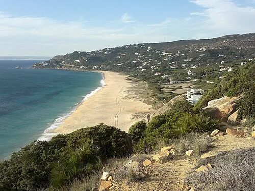
Playa de los Alemanes Benjamincebrian · CC BY-SA 3.0 -
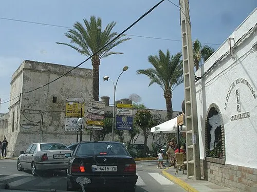
Castle of Zahara de los Atunes and Palace of Jadraza El Pantera · CC BY-SA 3.0


Climate of Zahara de los Atunes
Best months for sightseeingBest months for sightseeing: May–June, October.
This month · November
A wet month
Day 20° · Night 13° · Rain 133 mm
Better nearby cities in November
- Dos Hermanas · 128 km north20°
- Seville · 139 km north20°
- Málaga · 143 km northeast20°
- Hottest month
- August (day 29°)
- Coldest month
- January (night 9°)
- Wettest month
- November (133 mm)
- Driest month
- July (0 mm)
Bars: average monthly low and high temperature. Below: precipitation. Monthly averages for 1970–2000 at about 18 km resolution, adjusted for elevation. Highlighted months are mild and relatively dry. Source: WorldClim 2.1 (CC BY 4.0).
Show values as a table
| Month | Jan | Feb | Mar | Apr | May | Jun | Jul | Aug | Sep | Oct | Nov | Dec |
|---|---|---|---|---|---|---|---|---|---|---|---|---|
| Average high (°C) | 16° | 17° | 19° | 20° | 23° | 26° | 29° | 29° | 27° | 24° | 20° | 17° |
| Average low (°C) | 9° | 10° | 11° | 12° | 14° | 17° | 20° | 20° | 19° | 16° | 13° | 10° |
| Precipitation (mm) | 114 | 111 | 102 | 65 | 32 | 14 | 0 | 2 | 20 | 76 | 133 | 132 |
How to get to Zahara de los Atunes
The nearest airport is Gibraltar Airport (GIB), 45 km to the east as the crow flies. The nearest large city is Algeciras, 36 km to the east.
Airports
- Gibraltar Airport (GIB) Gibraltar 45 kmeast
- Tangier Ibn Battuta Airport (TNG) Tangier 45 kmsouth
- Jerez Airport (XRY) Jerez de la Frontera 70 kmnorth
Nearby large cities
- Algeciras Population: 121.4K 36 kmeast
- Cadiz Population: 117K 59 kmnorthwest
- Jerez de la Frontera Population: 212.9K 66 kmnorthwest
- Tétouan Population: 415.8K 75 kmsoutheast
- Marbella Population: 156.3K 96 kmnortheast
Straight-line distances; road distances are longer. Airport data: OurAirports.
Day trips from Zahara de los Atunes
Within 100 km: 286 historic and cultural sites, 173 natural sites, 291 lakes, rivers and coasts.
0–25 km58 places
- Playa de Zahora Beach 19 kmW
- Playa de Atlanterra Beach 3 kmSE
- Zahara de los Atunes. Beach 1 kmSW
- Los Caños de Meca Beach 16 kmW
25–60 km350 places
- Jebel Zem Zem Mountain 53 kmS
- Kasbah Mosque Attraction 39 kmS
- Grand Mosque of Tangier Attraction 39 kmS
- Baie De Tanger Natural site 40 kmS
60–100 km342 places
- Stade Saniat Rmel Landmark 77 kmSE
- Caleta Beach Beach 60 kmNW
- Playa de las Tres Piedras Beach 82 kmNW
- Playa de las Canteras Beach 86 kmNW
Straight-line distances.
Nearby attractions & nature
Everything nearby-
Castle of Zahara de los Atunes and Palace of Jadraza Historic site, Barbate0.1 km S
-
Zahara de los Atunes. Beach, Cadiz0.5 km SW
-
Arroyo de Acebuchal River, Barbate1.8 km E
-
Playa de Atlanterra Beach, Tarifa2.8 km SE
-
Playa de los Alemanes Beach, Tarifa5.3 km SE
-
Río Barbate River, Barbate7.3 km NW
Sources & licences
Data last updated: · 2 independent sources