Puig Moreno
Located in Alcañiz Municipality, Province of Teruel Coordinates: 41°06′23″ N 0°14′54″ W
- Elevation
- 311 m
- above sea level
- Local time
- UTC+01:00
- Europe/Madrid · UTC+01:00
- Airports
- ZAZ Zaragoza Airport91 km
- ILD Lleida-Alguaire Airport95 km
About Puig Moreno
Puig Moreno is a village. Location: Alcañiz Municipality, Province of Teruel. Elevation: 311 m. The best months to visit are April–May, October. The nearest airport is Zaragoza Airport (91 km). Nearby sights include La Estanca and Castle Calatravo.
Climate of Puig Moreno
Best months for sightseeingBest months for sightseeing: April–May, October.
This month · November
Outside the best season
Day 16° · Night 5° · Rain 32 mm
Better nearby cities in November
- Alicante · 308 km south20°
- Elche · 319 km south20°
- Orihuela · 341 km south20°
- Hottest month
- July (day 33°)
- Coldest month
- January (night 2°)
- Wettest month
- May (53 mm)
- Driest month
- July (16 mm)
Bars: average monthly low and high temperature. Below: precipitation. Monthly averages for 1970–2000 at about 18 km resolution, adjusted for elevation. Highlighted months are mild and relatively dry. Source: WorldClim 2.1 (CC BY 4.0).
Show values as a table
| Month | Jan | Feb | Mar | Apr | May | Jun | Jul | Aug | Sep | Oct | Nov | Dec |
|---|---|---|---|---|---|---|---|---|---|---|---|---|
| Average high (°C) | 12° | 14° | 18° | 20° | 24° | 29° | 33° | 32° | 28° | 22° | 16° | 12° |
| Average low (°C) | 2° | 3° | 4° | 7° | 11° | 14° | 17° | 17° | 14° | 10° | 5° | 3° |
| Precipitation (mm) | 24 | 19 | 24 | 39 | 53 | 36 | 16 | 25 | 41 | 43 | 32 | 32 |
How to get to Puig Moreno
The nearest airport is Zaragoza Airport (ZAZ), 91 km to the northwest as the crow flies. The nearest large city is Zaragoza, 81 km to the northwest.
Airports
- Zaragoza Airport (ZAZ) Zaragoza 91 kmnorthwest
- Lleida-Alguaire Airport (ILD) Lleida 95 kmnortheast
- Castellón-Costa Azahar Airport (CDT) Castellón de la Plana 103 kmsouth
Nearby large cities
- Zaragoza Population: 687K 81 kmnorthwest
- Lleida Population: 140.8K 92 kmnortheast
- Reus Population: 103.5K 114 kmeast
- Tarragona Population: 141.5K 125 kmeast
- Castellon Population: 183.7K 126 kmsouth
Straight-line distances; road distances are longer. Airport data: OurAirports.
Day trips from Puig Moreno
Within 100 km: 153 historic and cultural sites, 221 natural sites, 123 lakes, rivers and coasts.
0–25 km15 places
- Laguna Salada Lake 16 kmN
- La Estanca Lake 7 kmSE
- Sierra de Vizcuerno Mountain 14 kmE
- Glorieta Telmo Lacasa Natural site 11 kmSE
25–60 km95 places
- Pantano de Santolea Lake 40 kmS
- Pantano de La Peña Lake 45 kmSE
- Pantano de Moneva Lake 50 kmW
- Embalse de Mequinenza Lake 31 kmNE
60–100 km387 places
- Playa del Río Beach 94 kmSE
- Platja del Marjal Beach 90 kmSE
- L'Estanyet Beach 91 kmSE
- Platja de Garbí Beach 90 kmSE
Straight-line distances.
Nearby attractions & nature
Everything nearby-
La Estanca Lake, Alcañiz Municipality6.8 km SE
-
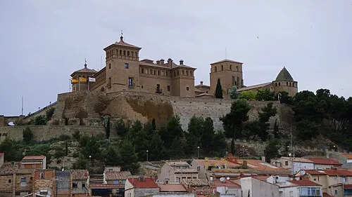 Castle Calatravo Historic site, Alcañiz Municipality12 km SE
-
Glorieta Telmo Lacasa Natural site, Alcañiz Municipality11 km SE
-
Museo de la Magia Museum, Alcañiz Municipality11 km SE
-
Church of Santa Maria La Mayor De Alcañiz Attraction, Alcañiz Municipality11 km SE
-
Capilla Distrito del Barón de Salillas Museum, Alcañiz Municipality12 km SE
Sources & licences
Data last updated: