- Elevation
- 925 m
- above sea level
- Local time
- UTC+01:00
- Europe/Madrid · UTC+01:00
- Airports
- MAD Adolfo Suárez Madrid–Barajas Airport85 km
- VLL Valladolid Airport91 km
About Arroyo de las Mulas
Arroyo de las Mulas is a river. Location: Veganzones, Segovia. The best months to visit are May–June, September. The nearest airport is Adolfo Suárez Madrid–Barajas Airport (85 km). Nearby sights include Arroyo de Valdealguis and Arroyo de Pinarejos.
Photos of Arroyo de las Mulas
-
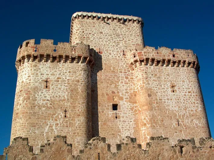
Castle of Turégano Wikimedia Commons · CC BY-SA 3.0

Climate of Arroyo de las Mulas
Best months for sightseeingBest months for sightseeing: May–June, September.
This month · November
A cold month
Day 11° · Night 2° · Rain 46 mm
- Hottest month
- July (day 29°)
- Coldest month
- January (night -1°)
- Wettest month
- May (52 mm)
- Driest month
- August (16 mm)
Bars: average monthly low and high temperature. Below: precipitation. Monthly averages for 1970–2000 at about 18 km resolution, adjusted for elevation. Highlighted months are mild and relatively dry. Source: WorldClim 2.1 (CC BY 4.0).
Show values as a table
| Month | Jan | Feb | Mar | Apr | May | Jun | Jul | Aug | Sep | Oct | Nov | Dec |
|---|---|---|---|---|---|---|---|---|---|---|---|---|
| Average high (°C) | 7° | 9° | 13° | 15° | 20° | 25° | 29° | 28° | 24° | 17° | 11° | 7° |
| Average low (°C) | -1° | -1° | 1° | 4° | 7° | 11° | 14° | 14° | 10° | 7° | 2° | 0° |
| Precipitation (mm) | 39 | 31 | 25 | 41 | 52 | 36 | 18 | 16 | 28 | 42 | 46 | 45 |
How to get to Arroyo de las Mulas
The nearest airport is Adolfo Suárez Madrid–Barajas Airport (MAD), 85 km to the southeast as the crow flies. The nearest large city is Alcobendas, 78 km to the southeast.
Airports
- Adolfo Suárez Madrid–Barajas Airport (MAD) Madrid 85 kmsoutheast
- Valladolid Airport (VLL) Valladolid 91 kmnorthwest
- Salamanca Airport (SLM) Salamanca 127 kmwest
Nearby large cities
- Alcobendas Population: 116K 78 kmsoutheast
- Valladolid Population: 300.6K 79 kmnorthwest
- Chamartin Population: 140K 85 kmsouth
- Ciudad Lineal Population: 228.2K 88 kmsouth
- Madrid Population: 3.3M 89 kmsouth
Straight-line distances; road distances are longer. Airport data: OurAirports.
Day trips from Arroyo de las Mulas
Within 100 km: 438 historic and cultural sites, 264 natural sites, 377 lakes, rivers and coasts.
0–25 km38 places
- Meseta Central Natural site 21 kmS
- Hoces del rio Duraton Natural site 19 kmNE
- Arroyo del Guijar de las Conchas River 23 kmSE
- Arroyo de la Gargantilla River 18 kmS
25–60 km251 places
- San Millán Attraction 28 kmS
- Embalse de Santillana Lake 54 kmS
- Pontón de la Oliva Lake 59 kmSE
- Embalse del Atazar Lake 55 kmSE
60–100 km790 places
- Laguna de Taeña Lake 74 kmSW
- Embalse del Burguillo Lake 97 kmSW
- Pantano de San Juan Lake 93 kmS
- Pantano de San Juan Lake 93 kmS
Straight-line distances.
Nearest towns and villages
-
Veganzones Village, Veganzones2.5 km NE
-
 Turégano Village, Turégano3.3 km S
-
Sauquillo de Cabezas Village, Sauquillo de Cabezas4.3 km W
-
Sauquillo de Cabezas Municipality, Segovia3.8 km NW
-
Turégano Municipality, Segovia5.9 km SE
-
Cabezuela Municipality, Segovia5.9 km NE
Nearby attractions & nature
Everything nearby-
Arroyo de Valdealguis River, Veganzones0.4 km N
-
Arroyo de Pinarejos River, Turégano1.6 km S
-
Arroyo de Valseco River, Turégano3.4 km S
-
Castle of Turégano Historic site, Turégano3.1 km SE
-
Arroyo de Santa Ana River, Cabezuela5.6 km N
-
Arroyo de las Regueras River, Puebla de Pedraza8.9 km E
-
Río Viejo River, Torreiglesias11 km S
-
Arroyo de Polendos River, Mozoncillo13 km SW
Sources & licences
Data last updated: