Cuenca
Located in Province of Cuenca, Castille-La Mancha Coordinates: 40°04′30″ N 2°08′10″ W
- Population
- 57,032
- 57K
- Elevation
- 924 m
- above sea level
- Local time
- UTC+01:00
- Europe/Madrid · UTC+01:00
- Places inside
- 67
- listed under Cuenca
- Airports
- MAD Adolfo Suárez Madrid–Barajas Airport131 km
- VLC Valencia Airport156 km
About Cuenca
Cuenca is a municipality. Location: Province of Cuenca, Castille-La Mancha. Population: 57,032. Elevation: 924 m. The best months to visit are May–June, September–October. The nearest airport is Adolfo Suárez Madrid–Barajas Airport (131 km). Nearby sights include Cerro del Castillo and Cerro Calderón.
Photos of Cuenca
-
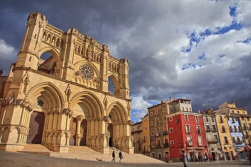
Cuenca Cathedral Tomás Fano · CC BY-SA 2.0

Climate of Cuenca
Best months for sightseeingBest months for sightseeing: May–June, September–October.
This month · November
Outside the best season
Day 13° · Night 3° · Rain 51 mm
Better nearby cities in November
- Elche · 236 km southeast20°
- Alicante · 239 km southeast20°
- Orihuela · 244 km southeast20°
- Hottest month
- July (day 31°)
- Coldest month
- January (night 0°)
- Wettest month
- May (62 mm)
- Driest month
- July (17 mm)
Bars: average monthly low and high temperature. Below: precipitation. Monthly averages for 1970–2000 at about 18 km resolution, adjusted for elevation. Highlighted months are mild and relatively dry. Source: WorldClim 2.1 (CC BY 4.0).
Show values as a table
| Month | Jan | Feb | Mar | Apr | May | Jun | Jul | Aug | Sep | Oct | Nov | Dec |
|---|---|---|---|---|---|---|---|---|---|---|---|---|
| Average high (°C) | 10° | 11° | 14° | 16° | 20° | 26° | 31° | 31° | 26° | 19° | 13° | 10° |
| Average low (°C) | 0° | 1° | 2° | 4° | 8° | 12° | 15° | 15° | 12° | 7° | 3° | 1° |
| Precipitation (mm) | 49 | 41 | 32 | 55 | 62 | 45 | 17 | 19 | 38 | 56 | 51 | 58 |
Other places to visit in this season: May June September October
How to get to Cuenca
The nearest airport is Adolfo Suárez Madrid–Barajas Airport (MAD), 131 km to the west as the crow flies. The nearest large city is Alcalá de Henares, 113 km to the northwest.
Airports
- Adolfo Suárez Madrid–Barajas Airport (MAD) Madrid 131 kmwest
- Valencia Airport (VLC) Valencia 156 kmsoutheast
- Castellón-Costa Azahar Airport (CDT) Castellón de la Plana 189 kmeast
Nearby large cities
- Alcalá de Henares Population: 193.8K 113 kmnorthwest
- Torrejón de Ardoz Population: 118.2K 121 kmwest
- Albacete Population: 173K 122 kmsouth
- Ciudad Lineal Population: 228.2K 135 kmwest
- Chamartin Population: 140K 138 kmwest
Straight-line distances; road distances are longer. Airport data: OurAirports.
Day trips from Cuenca
Within 100 km: 60 historic and cultural sites, 239 natural sites, 183 lakes, rivers and coasts.
0–25 km35 places
- Laguna de Uña Lake 22 kmNE
- Pantano de La Toba Lake 24 kmNE
- Cerro del Castillo Mountain 18 kmSW
- Cerro Calderón Mountain 25 kmS
25–60 km158 places
- Embalse de Alarcón Lake 53 kmS
- Laguna de Navahonda Lake 38 kmW
- Laguna Grande Lake 53 kmN
- Cerro de la Zorra Mountain 59 kmSE
60–100 km289 places
- Laguna de Manjavacas Lake 96 kmSW
- Pantano del Generalísimo Lake 98 kmSE
- Pantano de Entrepeñas Lake 73 kmNW
- Pantano de Buendía Lake 62 kmNW
Straight-line distances.
Cuenca and similar cities
Side by side with cities of similar size in the same country: population, elevation and climate.
| Measure | Cuenca | Ávila | Cuenca | Mérida |
|---|---|---|---|---|
| Population | 57K | 57.7K | 54.9K | 59.9K |
| Elevation | 924 m | 1,127 m | 941 m | 223 m |
| Summer day (hottest month) | 31° | 27° | 31° | 34° |
| Winter night (coldest month) | 0° | -1° | 0° | 4° |
| Annual rainfall | 523 mm | 500 mm | 523 mm | 534 mm |
| Best months | May–Jun, Sep–Oct | Jun, Sep | May–Jun, Sep–Oct | Mar–May, Oct |
| Distance | — | 227 km | 1 km | 384 km |
Climate values are 1970–2000 monthly averages; straight-line distance.
Places in Cuenca
67 placesCities & villages3
- Tondos · Village
- Valdecabras · Village
- Villanueva de los Escuderos · Village
Mountains & nature3
- Sierra de Cuenca · Mountain
- Sierra de Tragacete · Mountain
- Sierra de Valdemeca · Mountain
Heritage & sights1
- Teatro Auditorio de Cuenca · Attraction
Nearby attractions & nature
Everything nearby-
Cerro del Castillo Mountain, Valdetórtola18 km SW
-
Cerro Calderón Mountain, Valeras, Las25 km S
Other cities and towns in Province of Cuenca
-
Cuenca City, Cuenca0.9 km S
-
 Villalba de la Sierra Municipality, Province of Cuenca18 km N
-
 Buenache de la Sierra Municipality, Province of Cuenca14 km NE
-
 Fuentes Municipality, Province of Cuenca18 km SE
-
Fuentenava de Jábaga Municipality, Province of Cuenca15 km W
-
 Villar y Velasco Municipality, Province of Cuenca23 km W
Sources & licences
Data last updated: