Villamuelas
Located in Province of Toledo, Castille-La Mancha Coordinates: 39°48′05″ N 3°44′09″ W

- Population
- 729
- 729
- Elevation
- 593 m
- above sea level
- Local time
- UTC+01:00
- Europe/Madrid · UTC+01:00
- Places inside
- 1
- listed under Villamuelas
- Airports
- MAD Adolfo Suárez Madrid–Barajas Airport78 km
- SLM Salamanca Airport197 km
About Villamuelas
Villamuelas is a municipality. Location: Province of Toledo, Castille-La Mancha. Population: 729. Elevation: 593 m.
Villamuelas is a municipality located in the province of Toledo, Castile-La Mancha, Spain. According to the 2006 census (INE), the municipality has a population of 737 inhabitants.
Source: Wikipedia · CC BY-SA 4.0
Photos of Villamuelas
-

Centro Nacional de Información Geográfica · CC BY 4.0 -

Miguelasr · Public domain -

Miguelasr · Public domain


Places bordering Villamuelas
- Villasequilla
- Mascaraque
Population of Villamuelas over time
| 2014 | 692 | |
|---|---|---|
| 2015 | 671 | |
| 2016 | 651 | |
| 2017 | 632 | |
| 2018 | 620 | |
| 2019 | 612 | |
| 2020 | 606 | |
| 2021 | 613 | |
| 2022 | 610 | |
| 2023 | 613 | |
| 2024 | 613 | |
| 2025 | 587 |
Censuses and official estimates; source: Wikidata.
Climate of Villamuelas
Best months for sightseeingBest months for sightseeing: April–May, October.
This month · November
Outside the best season
Day 15° · Night 5° · Rain 46 mm
Better nearby cities in November
- Murcia · 303 km southeast20°
- Orihuela · 308 km southeast20°
- Elche · 313 km southeast20°
- Hottest month
- July (day 34°)
- Coldest month
- January (night 2°)
- Wettest month
- December (50 mm)
- Driest month
- August (9 mm)
Bars: average monthly low and high temperature. Below: precipitation. Monthly averages for 1970–2000 at about 18 km resolution, adjusted for elevation. Highlighted months are mild and relatively dry. Source: WorldClim 2.1 (CC BY 4.0).
Show values as a table
| Month | Jan | Feb | Mar | Apr | May | Jun | Jul | Aug | Sep | Oct | Nov | Dec |
|---|---|---|---|---|---|---|---|---|---|---|---|---|
| Average high (°C) | 11° | 14° | 17° | 19° | 24° | 30° | 34° | 34° | 29° | 21° | 15° | 12° |
| Average low (°C) | 2° | 3° | 5° | 7° | 10° | 15° | 19° | 18° | 15° | 10° | 5° | 3° |
| Precipitation (mm) | 37 | 33 | 27 | 45 | 46 | 28 | 12 | 9 | 23 | 43 | 46 | 50 |
How to get to Villamuelas
The nearest airport is Adolfo Suárez Madrid–Barajas Airport (MAD), 78 km to the north as the crow flies. The nearest large city is Parla, 48 km to the north.
Airports
- Adolfo Suárez Madrid–Barajas Airport (MAD) Madrid 78 kmnorth
- Salamanca Airport (SLM) Salamanca 197 kmnorthwest
- Valladolid Airport (VLL) Valladolid 232 kmnorthwest
Nearby large cities
- Parla Population: 115.6K 48 kmnorth
- Fuenlabrada Population: 190.5K 54 kmnorth
- Getafe Population: 187.5K 56 kmnorth
- Leganés Population: 188.4K 58 kmnorth
- Móstoles Population: 207.1K 59 kmnorth
Straight-line distances; road distances are longer. Airport data: OurAirports.
Day trips from Villamuelas
Within 100 km: 512 historic and cultural sites, 239 natural sites, 202 lakes, rivers and coasts.
0–25 km16 places
- Cerro del Buey Mountain 13 kmS
- Mesa de Ocaña Natural site 18 kmNE
- Río Jarama River 20 kmN
- Arroyo de Borox River 23 kmN
25–60 km240 places
- Pantano del Torcón Lake 58 kmW
- Laguna del Taray Lake 47 kmSE
- Laguna Larga Lake 42 kmSE
- La Laguna Lake 37 kmE
60–100 km697 places
- Laguna Romani Lake 84 kmS
- Laguna de Manjavacas Lake 86 kmSE
- Laguna de La Nava Lake 84 kmS
- Laguna de Fuentillejo Lake 100 kmS
Straight-line distances.
Places in Villamuelas
1 placeBar: population relative to the most populous place in this list.
Nearby attractions & nature
Everything nearby-
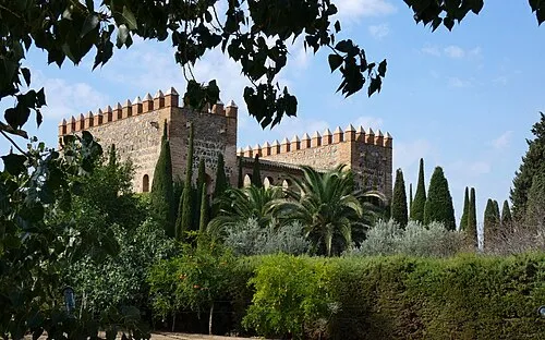 Palacio de Galiana Historic site, Toledo24 km W
-
Arroyo Cedrón River, Guardia, La11 km E
-
Castillo de Almonacid Historic site, Almonacid de Toledo12 km SW
-
Cerro del Buey Mountain, Mora13 km S
-
Castillo de Peñas Negras Historic site, Mora13 km S
-
Arroyo de la Madre River, Guardia, La12 km NE
-
Mesa de Ocaña Natural site, Ocaña18 km NE
-
Castle of San Servando Landmark, Toledo25 km W
Other cities and towns in Province of Toledo
-
 Toledo Municipality, Province of Toledo25 km W
-
 Nambroca Municipality, Province of Toledo15 km W
-
 Villaminaya Municipality, Province of Toledo15 km SW
-
 Villaseca de la Sagra Municipality, Province of Toledo21 km NW
-
 Burguillos de Toledo Municipality, Province of Toledo23 km W
-
 Dosbarrios Municipality, Province of Toledo21 km E
Sources & licences
Data last updated: · 2 independent sources