
- Population
- 496
- 496
- Elevation
- 758 m
- above sea level
- Local time
- UTC+01:00
- Europe/Madrid · UTC+01:00
- Airports
- LEU Pirineus - la Seu d'Urgel Airport3 km
- ILD Lleida-Alguaire Airport102 km
About Castellciutat
Castellciutat is a village. Location: Alàs i Cerc, Lleida. Population: 496. Elevation: 758 m.
Castellciutat (Catalan pronunciation: [kəsˌteʎsiwˈtat]) is a village in the municipality of la Seu d'Urgell (Alt Urgell, Catalonia). In the past it was called Ciutat (City in English) but is now called either Ciutat or Castellciutat. It has a population of 451 inhabitants. There is an old castle, Castell de Ciutat (Castle of the City), which gives its name to the village.
Source: Wikipedia · CC BY-SA 4.0
Photos of Castellciutat
-
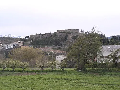
Castell de Ciutat Vinals · CC BY-SA 3.0

Population of Castellciutat over time
| 1991 | 496 | |
|---|---|---|
| 2000 | 422 | |
| 2010 | 463 | |
| 2023 | 432 | |
| 2024 | 423 | |
| 2025 | 424 |
Censuses and official estimates; source: Wikidata.
Climate of Castellciutat
Best months for sightseeingBest months for sightseeing: June–July, September.
This month · November
Outside the best season
Day 12° · Night 4° · Rain 93 mm
- Hottest month
- July (day 27°)
- Coldest month
- January (night 0°)
- Wettest month
- May (106 mm)
- Driest month
- July (61 mm)
Bars: average monthly low and high temperature. Below: precipitation. Monthly averages for 1970–2000 at about 18 km resolution, adjusted for elevation. Highlighted months are mild and relatively dry. Source: WorldClim 2.1 (CC BY 4.0).
Show values as a table
| Month | Jan | Feb | Mar | Apr | May | Jun | Jul | Aug | Sep | Oct | Nov | Dec |
|---|---|---|---|---|---|---|---|---|---|---|---|---|
| Average high (°C) | 8° | 9° | 12° | 14° | 18° | 23° | 27° | 27° | 23° | 17° | 12° | 9° |
| Average low (°C) | 0° | 1° | 2° | 4° | 8° | 11° | 14° | 15° | 12° | 8° | 4° | 1° |
| Precipitation (mm) | 70 | 66 | 64 | 77 | 106 | 94 | 61 | 79 | 79 | 92 | 93 | 77 |
How to get to Castellciutat
The nearest airport is Pirineus - la Seu d'Urgel Airport (LEU), 3 km to the southwest as the crow flies. The nearest large city is Terrassa, 100 km to the southeast.
Airports
- Pirineus - la Seu d'Urgel Airport (LEU) La Seu d'Urgell Pyrenees and Andorra 3 kmsouthwest
- Lleida-Alguaire Airport (ILD) Lleida 102 kmsouthwest
- Carcassonne Salvaza Airport (CCF) Carcassonne 119 kmnortheast
Nearby large cities
- Terrassa Population: 218.5K 100 kmsoutheast
- Sabadell Population: 211.7K 106 kmsoutheast
- Lleida Population: 140.8K 106 kmsouthwest
- Santa Coloma de Gramenet Population: 118.8K 119 kmsoutheast
- Badalona Population: 217.7K 121 kmsoutheast
Straight-line distances; road distances are longer. Airport data: OurAirports.
Day trips from Castellciutat
Within 100 km: 179 historic and cultural sites, 1,777 natural sites, 231 lakes, rivers and coasts.
0–25 km107 places
- Pic de la Bassera Mountain 20 kmN
- Pic de la Raconada de la Maiana Mountain 18 kmNE
- Serrat dels Punxons Mountain 16 kmN
- Tossa Plana de Lles Mountain 22 kmNE
25–60 km776 places
- Artigue River 53 kmNW
- Pantà de Sant Antoni Lake 44 kmW
- Estany de Travessani Lake 54 kmNW
- Pantà de Terradets Lake 55 kmSW
60–100 km1,304 places
- Esglesia de Sant Esteve de Ginast Attraction 62 kmW
- Estany d'Ivars i Vila-san Lake 85 kmSW
- Pantà de Susqueda Lake 98 kmSE
- Pantà de Sant Llorenç de Montgai Lake 74 kmSW
Straight-line distances.
Nearby attractions & nature
Everything nearby-
Castell de Ciutat Historic site, la Seu d'Urgell0.5 km NE
-
Cal Feliuet Historic site, la Seu d'Urgell0.4 km NE
-
Cathedral of Santa Maria dUrgell Attraction, Alàs i Cerc1.7 km E
-
Can Molines Historic site, la Seu d'Urgell1.5 km E
-
Cal Patalin Historic site, la Seu d'Urgell1.7 km E
-
la Valira River, la Seu d'Urgell0.4 km SE
Sources & licences
Data last updated: · 2 independent sources