- Elevation
- -1 m
- above sea level
- Local time
- UTC+01:00
- Europe/Madrid · UTC+01:00
- Airports
- REU Reus Airport62 km
- CDT Castellón-Costa Azahar Airport79 km
About Balsa de La Platjola
Balsa de La Platjola is a lake. Location: Amposta, Tarragona. Elevation: -1 m. The best months to visit are April–June, October. The nearest airport is Reus Airport (62 km). Nearby sights include Balsa de Anfacadas and Laguna de la Tancada.
Photos of Balsa de La Platjola
-
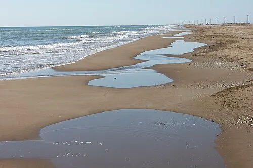
Platja del Trabucador carlos corzo · CC BY-SA 3.0

Climate of Balsa de La Platjola
Best months for sightseeingBest months for sightseeing: April–June, October.
This month · November
Outside the best season
Day 18° · Night 9° · Rain 60 mm
Better nearby cities in November
- Alicante · 281 km southwest20°
- Elche · 297 km southwest20°
- Orihuela · 324 km southwest20°
- Hottest month
- August (day 29°)
- Coldest month
- January (night 6°)
- Wettest month
- October (88 mm)
- Driest month
- July (14 mm)
Bars: average monthly low and high temperature. Below: precipitation. Monthly averages for 1970–2000 at about 18 km resolution, adjusted for elevation. Highlighted months are mild and relatively dry. Source: WorldClim 2.1 (CC BY 4.0).
Show values as a table
| Month | Jan | Feb | Mar | Apr | May | Jun | Jul | Aug | Sep | Oct | Nov | Dec |
|---|---|---|---|---|---|---|---|---|---|---|---|---|
| Average high (°C) | 14° | 16° | 18° | 20° | 23° | 26° | 29° | 29° | 27° | 23° | 18° | 15° |
| Average low (°C) | 6° | 6° | 8° | 9° | 13° | 17° | 20° | 20° | 17° | 14° | 9° | 7° |
| Precipitation (mm) | 35 | 28 | 40 | 43 | 53 | 34 | 14 | 36 | 81 | 88 | 60 | 50 |
Other places to visit in this season: April May June October
How to get to Balsa de La Platjola
The nearest airport is Reus Airport (REU), 62 km to the northeast as the crow flies. The nearest large city is Reus, 60 km to the northeast.
Airports
- Reus Airport (REU) Reus 62 kmnortheast
- Castellón-Costa Azahar Airport (CDT) Castellón de la Plana 79 kmsouthwest
- Lleida-Alguaire Airport (ILD) Lleida 120 kmnorth
Nearby large cities
- Reus Population: 103.5K 60 kmnortheast
- Tarragona Population: 141.5K 63 kmnortheast
- Castellon Population: 183.7K 104 kmsouthwest
- Lleida Population: 140.8K 106 kmnorth
- L'Hospitalet de Llobregat Population: 257K 134 kmnortheast
Straight-line distances; road distances are longer. Airport data: OurAirports.
Day trips from Balsa de La Platjola
Within 100 km: 152 historic and cultural sites, 226 natural sites, 163 lakes, rivers and coasts.
0–25 km57 places
- Platja de Garbí Beach 18 kmW
- Playa Cementera Beach 23 kmSW
- Platja Avellanes Beach 17 kmN
- Playa L'Ampolla Beach 17 kmN
25–60 km213 places
- Playa del Río Beach 35 kmSW
- Playa del Rincón Beach 55 kmNE
- Playa de Rifá Beach 44 kmN
- Platja del Marjal Beach 26 kmSW
60–100 km271 places
- Playa Roda Beach 62 kmSW
- Playa del Moro Beach 66 kmSW
- Playa del Cargador Beach 64 kmSW
- Heliòpolis Beach 91 kmSW
Straight-line distances.
Nearest towns and villages
-
Sant Jaume d'Enveja Municipality, Tarragona2.6 km N
-
l'Eucaliptus Village, Amposta1.1 km SW
-
Deltebre Town, Deltebre9 km NW
-
Deltebre Municipality, Tarragona9 km N
-
Riumar Village, Deltebre7.5 km NE
-
la Cava Village, Amposta7.3 km NW
Nearby attractions & nature
Everything nearby-
Balsa de Anfacadas Lake, Sant Jaume d'Enveja3.9 km NE
-
Laguna de la Tancada Lake, Amposta5 km SW
-
Balsa de la Creu Lake, Deltebre5.3 km N
-
Balsa L'Illot Lake, Amposta5.4 km N
-
Platja del Trabucador Beach, Sant Carles de la Ràpita6.8 km SW
-
Illa de Buda Island, Sant Jaume d'Enveja7.2 km NE
-
Balsa de la Arena Lake, Deltebre7.5 km N
-
Isla del Mar Island, Amposta9.7 km N
Sources & licences
Data last updated: