- Elevation
- 1,611 m
- above sea level
- Local time
- UTC+01:00
- Europe/Madrid · UTC+01:00
- Airports
- BGC Bragança Airport88 km
- SCQ Santiago-Rosalía de Castro Airport110 km
About Paxaro
Paxaro is a mountain. Location: Folgoso do Courel, Lugo. Elevation: 1,611 m. The best months to visit are July–August. The nearest airport is Bragança Airport (88 km). Nearby sights include Pía Paxaro and Serra do Courel.
Climate of Paxaro
Best months for sightseeingBest months for sightseeing: July–August.
This month · November
A wet month
Day 6° · Night -1° · Rain 163 mm
- Hottest month
- July (day 20°)
- Coldest month
- January (night -4°)
- Wettest month
- December (176 mm)
- Driest month
- July (39 mm)
Bars: average monthly low and high temperature. Below: precipitation. Monthly averages for 1970–2000 at about 18 km resolution, adjusted for elevation. Highlighted months are mild and relatively dry. Source: WorldClim 2.1 (CC BY 4.0).
Show values as a table
| Month | Jan | Feb | Mar | Apr | May | Jun | Jul | Aug | Sep | Oct | Nov | Dec |
|---|---|---|---|---|---|---|---|---|---|---|---|---|
| Average high (°C) | 3° | 4° | 7° | 9° | 12° | 17° | 20° | 20° | 17° | 11° | 6° | 4° |
| Average low (°C) | -4° | -4° | -2° | -1° | 2° | 6° | 8° | 8° | 6° | 3° | -1° | -3° |
| Precipitation (mm) | 164 | 135 | 109 | 114 | 109 | 64 | 39 | 41 | 80 | 150 | 163 | 176 |
How to get to Paxaro
The nearest airport is Bragança Airport (BGC), 88 km to the southeast as the crow flies. For international flights: Santiago-Rosalía de Castro Airport (SCQ) (110 km). The nearest large city is Ourense, 65 km to the southwest.
Airports
- Bragança Airport (BGC) Bragança 88 kmsoutheast
- Santiago-Rosalía de Castro Airport (SCQ) Santiago de Compostela 110 kmwest
- León Airport (LEN) La Virgen del Camino 122 kmeast
Nearby large cities
- Ourense Population: 105.2K 65 kmsouthwest
- León Population: 124.8K 129 kmeast
- A Coruña Population: 250.4K 135 kmnorthwest
- Vigo Population: 293.6K 136 kmwest
- Oviedo Population: 220K 137 kmnortheast
Straight-line distances; road distances are longer. Airport data: OurAirports.
Day trips from Paxaro
Within 100 km: 83 historic and cultural sites, 153 natural sites, 292 lakes, rivers and coasts.
0–25 km25 places
- Pía Paxaro Mountain 1 kmNE
- A Escrita Mountain 10 kmNW
- Alto de Torrentes Mountain 17 kmNW
- Pico do Polvoreiro Mountain 17 kmNW
25–60 km162 places
- Embalse de Belesar Lake 49 kmW
- Serra do Invernadoiro Mountain 50 kmS
- Alto da Viuveza Mountain 55 kmSW
- Sierra Segundera Mountain 55 kmS
60–100 km341 places
- Pantano de Villameca Lake 89 kmE
- Lago de Sanabria Lake 62 kmSE
- Pico Casa Mountain 89 kmNW
- Sierra de la Gamoneda Mountain 69 kmS
Straight-line distances.
Nearest towns and villages
-
Vilarbacú Village, Folgoso do Courel2.1 km SE
-
Ferreirós de Arriba Village, Folgoso do Courel3 km NW
-
Parada do Courel Village, Folgoso do Courel5.4 km N
-
Folgoso do Courel Village, Folgoso do Courel4.3 km W
-
Santa Eufemia Village, Folgoso do Courel4.4 km W
-
Ferreirós de Abaixo Village, Folgoso do Courel4.5 km NW
Nearby attractions & nature
Everything nearby-
Pía Paxaro Mountain, Folgoso do Courel0.3 km NE
-
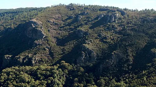 Serra do Courel Mountain, Folgoso do Courel1.9 km W
-
Campín de Murelos Mountain, Quiroga1.3 km NE
-
Formigueiros Mountain, Folgoso do Courel4.6 km NE
-
Río Louzara River, Folgoso do Courel5.5 km W
-
A Escrita Mountain, Folgoso do Courel10 km NW
-
Pico do Polvoreiro Mountain, Samos17 km NW
-
Alto de Torrentes Mountain, Samos17 km NW
Sources & licences
Data last updated: