- Elevation
- 1,380 m
- above sea level
- Local time
- UTC+01:00
- Europe/Madrid · UTC+01:00
- Airports
- ALC Alicante-Elche Miguel Hernández Airport53 km
- VLC Valencia Airport88 km
About el Pla de la Casa
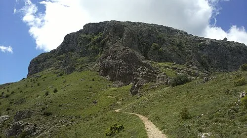
el Pla de la Casa is a mountain. Location: Quatretondeta, Alicante. Elevation: 1,380 m. The best months to visit are June, August–September. The nearest airport is Alicante-Elche Miguel Hernández Airport (53 km). Nearby sights include Sierra de Serrella and la Mallada del Llop.
Climate of el Pla de la Casa
Best months for sightseeingBest months for sightseeing: June, August–September.
This month · November
A cold month
Day 10° · Night -1° · Rain 38 mm
Better nearby cities in November
- Alicante · 44 km south20°
- Elche · 61 km southwest20°
- Orihuela · 90 km southwest20°
- Hottest month
- July (day 28°)
- Coldest month
- January (night -5°)
- Wettest month
- April (49 mm)
- Driest month
- July (12 mm)
Bars: average monthly low and high temperature. Below: precipitation. Monthly averages for 1970–2000 at about 18 km resolution, adjusted for elevation. Highlighted months are mild and relatively dry. Source: WorldClim 2.1 (CC BY 4.0).
Show values as a table
| Month | Jan | Feb | Mar | Apr | May | Jun | Jul | Aug | Sep | Oct | Nov | Dec |
|---|---|---|---|---|---|---|---|---|---|---|---|---|
| Average high (°C) | 6° | 8° | 11° | 13° | 17° | 23° | 28° | 27° | 22° | 16° | 10° | 6° |
| Average low (°C) | -5° | -4° | -2° | 0° | 4° | 8° | 11° | 12° | 8° | 4° | -1° | -4° |
| Precipitation (mm) | 25 | 26 | 31 | 49 | 49 | 33 | 12 | 13 | 35 | 47 | 38 | 32 |
How to get to el Pla de la Casa
The nearest airport is Alicante-Elche Miguel Hernández Airport (ALC), 53 km to the southwest as the crow flies. The nearest large city is Alicante, 44 km to the south.
Airports
- Alicante-Elche Miguel Hernández Airport (ALC) Alicante 53 kmsouthwest
- Valencia Airport (VLC) Valencia 88 kmnorth
- Region of Murcia International Airport (RMU) Corvera 124 kmsouthwest
Nearby large cities
- Alicante Population: 348.9K 44 kmsouth
- Elche Population: 234.8K 61 kmsouthwest
- Valencia Population: 824.3K 85 kmnorth
- Orihuela Population: 101.3K 90 kmsouthwest
- Murcia Population: 472K 109 kmsouthwest
Straight-line distances; road distances are longer. Airport data: OurAirports.
Day trips from el Pla de la Casa
Within 100 km: 422 historic and cultural sites, 232 natural sites, 155 lakes, rivers and coasts.
0–25 km111 places
- Platja d'Altea Beach 25 kmSE
- Platja de l'Albir Beach 25 kmSE
- Playa de Levante Beach 25 kmSE
- Playa de Poniente Beach 23 kmSE
25–60 km324 places
- Museo de La Asegurada Museum 44 kmS
- MUBAG Museum 44 kmS
- MARQ - Museo Arqueológico Museum 43 kmS
- Playa Nort de Gandía Beach 36 kmN
60–100 km374 places
- Playa del Cura Beach 89 kmS
- Playa del Acequión Beach 90 kmSW
- Malvarrosa Beach Beach 85 kmN
- Playa Massalfassar Beach 94 kmN
Straight-line distances.
Nearest towns and villages
Nearby attractions & nature
Everything nearby-
Sierra de Serrella Mountain, Confrides1.8 km E
-
la Mallada del Llop Mountain, Confrides4.3 km E
-
Alfaro Mountain, Famorca5.8 km NE
-
Aitana Mountain, Sella7.2 km S
-
Tossal Querola Mountain, Beniarrés13 km NW
-
Barranco de la Cara de la Vila Mountain, Beniarrés13 km NW
-
 El Montcabrer Mountain, Cocentaina18 km W
-
El Mau Mountain, Planes13 km NW
Sources & licences
Data last updated: