- Elevation
- 265 m
- above sea level
- Local time
- UTC+01:00
- Europe/Stockholm · UTC+01:00
- Airports
- OSD Åre Östersund Airport28 km
- KRF Kramfors-Sollefteå Höga Kusten Airport145 km
About Lit socken
Lit socken is a village. Location: Lit, Östersund municipality. Elevation: 265 m. The best months to visit are June–August. The nearest airport is Åre Östersund Airport (28 km). Nearby sights include Jämtkraft Arena and Högen.
Climate of Lit socken
Best months for sightseeingBest months for sightseeing: June–August.
This month · November
A cold month
Day 0° · Night -5° · Rain 48 mm
- Hottest month
- July (day 19°)
- Coldest month
- January (night -11°)
- Wettest month
- July (88 mm)
- Driest month
- February (31 mm)
Bars: average monthly low and high temperature. Below: precipitation. Monthly averages for 1970–2000 at about 18 km resolution, adjusted for elevation. Highlighted months are mild and relatively dry. Source: WorldClim 2.1 (CC BY 4.0).
Show values as a table
| Month | Jan | Feb | Mar | Apr | May | Jun | Jul | Aug | Sep | Oct | Nov | Dec |
|---|---|---|---|---|---|---|---|---|---|---|---|---|
| Average high (°C) | -4° | -3° | 1° | 6° | 13° | 17° | 19° | 17° | 12° | 6° | 0° | -3° |
| Average low (°C) | -11° | -10° | -7° | -3° | 3° | 7° | 9° | 8° | 4° | 0° | -5° | -9° |
| Precipitation (mm) | 39 | 31 | 31 | 35 | 42 | 65 | 88 | 71 | 61 | 55 | 48 | 42 |
How to get to Lit socken
The nearest airport is Åre Östersund Airport (OSD), 28 km to the southwest as the crow flies. The nearest large city is Trondheim, 229 km to the west.
Airports
- Åre Östersund Airport (OSD) Östersund 28 kmsouthwest
- Kramfors-Sollefteå Höga Kusten Airport (KRF) Nyland 145 kmeast
- Sundsvall-Härnösand Airport (SDL) Sundsvall/ Härnösand 155 kmsoutheast
Nearby large cities
- Trondheim Population: 216.5K 229 kmwest
- Umeå Population: 130.2K 268 kmeast
Straight-line distances; road distances are longer. Airport data: OurAirports.
Day trips from Lit socken
Within 100 km: 1 historic or cultural site, 53 natural sites, 4 lakes, rivers and coasts.
0–25 km2 places
- Högen Mountain 21 kmN
- Jämtkraft Arena Landmark 22 kmSW
25–60 km2 places
- Hästön Island 55 kmW
- Näset Natural site 31 kmNE
60–100 km54 places
- Digerön Island 69 kmN
- Lillön Island 60 kmNE
- Grönön Island 61 kmNE
- Västerskutan Mountain 95 kmW
Straight-line distances.
Nearby attractions & nature
Everything nearby-
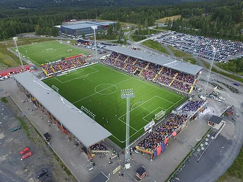 Jämtkraft Arena Landmark, Östersund socken22 km SW
-
Högen Mountain, Östersund municipality21 km N
Sources & licences
Data last updated: