Malmberget
Located in Gällivare Municipality, Norrbotten County Coordinates: 67°10′31″ N 20°39′18″ E
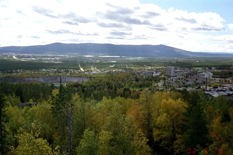
- Population
- 6,017
- 6K
- Elevation
- 418 m
- above sea level
- Local time
- UTC+01:00
- Europe/Stockholm · UTC+01:00
- Airports
- GEV Gällivare Airport8 km
- KRN Kiruna Airport73 km
About Malmberget
Malmberget is a town. Location: Gällivare Municipality, Norrbotten County. Population: 6,017. Elevation: 418 m.
Malmberget (lit. 'The Ore Mountain'; Finnish: Malmivaara; Meänkieli: Malmivaara) is a locality and mining town situated in Gällivare Municipality, Norrbotten County, Sweden. It had 5,590 inhabitants in 2010, reduced to 927 by December 2020. It is situated five kilometres (3 mi) from the municipal seat of Gällivare. The entire Malmberget town was moved in 2020/2021 due to mining activities in the area. Malmberget is known as a major site for the extraction of iron ore from deep mines by Swedish mining company LKAB.
Source: Wikipedia · CC BY-SA 4.0
At a glance
- Area
- 66 ha
Source: Wikidata
Photos of Malmberget
-

Myszka2891 · CC BY-SA 4.0 -

Jens Cederskjold from København S, Danmark · CC BY-SA 2.0 -

Lantgård · CC BY-SA 4.0 -

Lantgård · CC0 -

Unknown author Unknown author · CC0


Population of Malmberget over time
| 2010 | 5,590 | |
|---|---|---|
| 2015 | 1,757 | |
| 2016 | 1,771 | |
| 2017 | 1,638 | |
| 2018 | 1,570 | |
| 2019 | 1,065 | |
| 2020 | 927 | |
| 2023 | 306 |
Censuses and official estimates; source: Wikidata.
Climate of Malmberget
Best months for sightseeingBest months for sightseeing: June–August.
This month · November
A cold month
Day -4° · Night -11° · Rain 45 mm
- Hottest month
- July (day 18°)
- Coldest month
- January (night -17°)
- Wettest month
- July (90 mm)
- Driest month
- February (27 mm)
Bars: average monthly low and high temperature. Below: precipitation. Monthly averages for 1970–2000 at about 18 km resolution, adjusted for elevation. Highlighted months are mild and relatively dry. Source: WorldClim 2.1 (CC BY 4.0).
Show values as a table
| Month | Jan | Feb | Mar | Apr | May | Jun | Jul | Aug | Sep | Oct | Nov | Dec |
|---|---|---|---|---|---|---|---|---|---|---|---|---|
| Average high (°C) | -8° | -7° | -3° | 3° | 9° | 15° | 18° | 15° | 10° | 2° | -4° | -7° |
| Average low (°C) | -17° | -17° | -13° | -6° | 0° | 6° | 9° | 7° | 2° | -4° | -11° | -16° |
| Precipitation (mm) | 33 | 27 | 27 | 27 | 40 | 56 | 90 | 73 | 50 | 45 | 45 | 36 |
How to get to Malmberget
The nearest airport is Gällivare Airport (GEV), 8 km to the southeast as the crow flies. For international flights: Kiruna Airport (KRN) (73 km). The nearest large city is Umeå, 374 km to the south.
Airports
- Gällivare Airport (GEV) Gällivare 8 kmsoutheast
- Kiruna Airport (KRN) Kiruna 73 kmnorth
- Enontekio Airport (ENF) Enontekio 177 kmnortheast
Nearby large cities
- Umeå Population: 130.2K 374 kmsouth
Straight-line distances; road distances are longer. Airport data: OurAirports.
Day trips from Malmberget
Within 100 km: 96 natural sites, 16 lakes, rivers and coasts.
0–25 km6 places
- Vuoskonvare Mountain 7 kmW
- Kuolpavaara Mountain 16 kmS
- Keble Mountain 23 kmNW
- Akkavaara Mountain 18 kmSW
25–60 km30 places
- Hukkasaari Island 44 kmNW
- Tonkaperseet Mountain 36 kmS
- Piessimvaara Mountain 47 kmS
- Gähppovárre Mountain 43 kmSW
60–100 km76 places
- Ilansonsaari Island 90 kmN
- Stohkkeoaivi Mountain 61 kmN
- Stuortjåhkkå Mountain 98 kmSW
- Spadnoajvve Mountain 93 kmSW
Straight-line distances.
Nearby attractions & nature
Everything nearby-
Vuoskonvare Mountain, Gällivare Municipality7.5 km W
-
Patsatjåkko Mountain, Gällivare Municipality9 km N
-
Kuolpavaara Mountain, Gällivare Municipality16 km S
-
Harriåive Mountain, Gällivare Municipality18 km NE
-
Akkavaara Mountain, Gällivare Municipality18 km SW
-
Keble Mountain, Gällivare Municipality23 km NW
Sources & licences
Data last updated: · 2 independent sources