- Population
- 1,053
- 1.1K
- Elevation
- 17 m
- above sea level
- Local time
- UTC+01:00
- Europe/Stockholm · UTC+01:00
- Airports
- BMA Stockholm-Bromma Airport25 km
- ARN Stockholm-Arlanda Airport49 km
About Älgöö
Älgöö is a village. Location: Nacka Municipality, Stockholm County. Population: 1,053. Elevation: 17 m.
Älgö is a locality situated in Nacka Municipality, Stockholm County, Sweden. It is also a peninsula next to Saltsjöbaden, in Stockholm Archipelago. Älgö is surrounded by Baggensfjärden, Ingaröfjärden and Erstaviken. Since 2015, the settlement has been constituted as its own urban area. The town already met the resident requirement for an urban area (200) by a very wide margin, but then had too high a proportion of leisure properties.
Source: Wikipedia · CC BY-SA 4.0
At a glance
- Area
- 2 km²
Source: Wikidata
Population of Älgöö over time
| 1990 | 303 | |
|---|---|---|
| 2005 | 591 | |
| 2010 | 751 | |
| 2015 | 908 | |
| 2016 | 930 | |
| 2017 | 986 | |
| 2018 | 991 | |
| 2019 | 1,026 | |
| 2020 | 1,053 | |
| 2023 | 1,040 |
Censuses and official estimates; source: Wikidata.
Climate of Älgöö
Best months for sightseeingBest months for sightseeing: June–August.
This month · November
A cold month
Day 5° · Night 0° · Rain 64 mm
- Hottest month
- July (day 22°)
- Coldest month
- February (night -5°)
- Wettest month
- July (69 mm)
- Driest month
- February (29 mm)
Bars: average monthly low and high temperature. Below: precipitation. Monthly averages for 1970–2000 at about 18 km resolution, adjusted for elevation. Highlighted months are mild and relatively dry. Source: WorldClim 2.1 (CC BY 4.0).
Show values as a table
| Month | Jan | Feb | Mar | Apr | May | Jun | Jul | Aug | Sep | Oct | Nov | Dec |
|---|---|---|---|---|---|---|---|---|---|---|---|---|
| Average high (°C) | 1° | 1° | 3° | 8° | 15° | 19° | 22° | 20° | 15° | 10° | 5° | 2° |
| Average low (°C) | -5° | -5° | -3° | 0° | 5° | 9° | 12° | 12° | 8° | 4° | 0° | -3° |
| Precipitation (mm) | 43 | 29 | 34 | 37 | 31 | 55 | 69 | 60 | 60 | 54 | 64 | 53 |
How to get to Älgöö
The nearest airport is Stockholm-Bromma Airport (BMA), 25 km to the northwest as the crow flies. For international flights: Stockholm-Arlanda Airport (ARN) (49 km). The nearest large city is Stockholm, 17 km to the northwest.
Airports
- Stockholm-Bromma Airport (BMA) Stockholm 25 kmnorthwest
- Stockholm-Arlanda Airport (ARN) Stockholm 49 kmnorthwest
- Stockholm Skavsta Airport (NYO) Nyköping 97 kmsouthwest
Nearby large cities
- Stockholm Population: 1.5M 17 kmnorthwest
- Sollentuna Population: 139.6K 29 kmnorthwest
- Västerås Population: 127.8K 109 kmwest
- Örebro Population: 156K 178 kmwest
- Jönköping Population: 112.8K 294 kmsouthwest
Straight-line distances; road distances are longer. Airport data: OurAirports.
Day trips from Älgöö
Within 100 km: 38 historic and cultural sites, 78 natural sites, 1,074 lakes, rivers and coasts.
0–25 km271 places
- Rindö Island 16 kmN
- Runmarö Island 25 kmE
- Galtholmen Island 24 kmNE
- Högholmen Island 22 kmS
25–60 km683 places
- Husarö Island 40 kmNE
- Ostkanten Island 29 kmNE
- Gubbholmen Island 33 kmS
- Oxholmen Island 41 kmS
60–100 km236 places
- Lillö Island 67 kmE
- Granskär Island 65 kmW
- Högholmen Natural site 68 kmNE
- Hamnholmen Island 69 kmNE
Straight-line distances.
Nearby attractions & nature
Everything nearby-
Kilholmen Island, Boo socken1.1 km E
-
Furuholmen Island, Stockholm County1.2 km NW
-
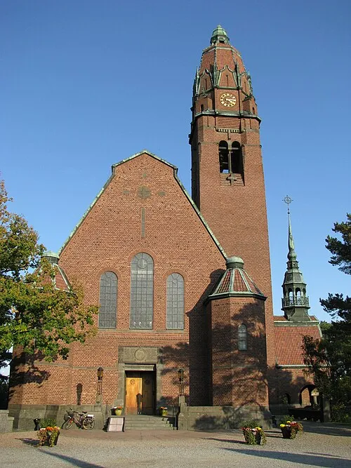 Uppenbarelsekyrkan Attraction, Boo socken3.3 km NW
-
Korsholmen Island, Stockholm County1.9 km N
-
Tallskär Island, Stockholm County2.8 km E
-
Norra Norrholmen Island, Stockholm County3.6 km E
Sources & licences
Data last updated: · 2 independent sources