- Elevation
- 1 m
- above sea level
- Local time
- UTC+01:00
- Europe/Stockholm · UTC+01:00
- Airports
- GOT Göteborg Landvetter Airport44 km
- THN Trollhättan-Vänersborg Airport66 km
About Brandholmen
Brandholmen is an island. Location: Västra Götaland County, Sweden. The best months to visit are June–August. The nearest airport is Göteborg Landvetter Airport (44 km). Nearby sights include Ängholmen and Långö.
Photos of Brandholmen
-
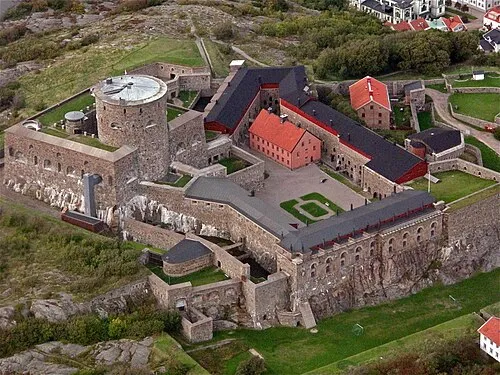
Carlsten Fortress Jenbuc · CC BY 3.0

Climate of Brandholmen
Best months for sightseeingBest months for sightseeing: June–August.
This month · November
A cold month
Day 7° · Night 2° · Rain 87 mm
- Hottest month
- July (day 21°)
- Coldest month
- February (night -4°)
- Wettest month
- November (87 mm)
- Driest month
- April (41 mm)
Bars: average monthly low and high temperature. Below: precipitation. Monthly averages for 1970–2000 at about 18 km resolution, adjusted for elevation. Highlighted months are mild and relatively dry. Source: WorldClim 2.1 (CC BY 4.0).
Show values as a table
| Month | Jan | Feb | Mar | Apr | May | Jun | Jul | Aug | Sep | Oct | Nov | Dec |
|---|---|---|---|---|---|---|---|---|---|---|---|---|
| Average high (°C) | 2° | 2° | 5° | 9° | 16° | 19° | 21° | 20° | 16° | 11° | 7° | 4° |
| Average low (°C) | -3° | -4° | -1° | 2° | 6° | 10° | 12° | 12° | 9° | 6° | 2° | -1° |
| Precipitation (mm) | 61 | 45 | 52 | 41 | 46 | 61 | 60 | 71 | 86 | 81 | 87 | 75 |
How to get to Brandholmen
The nearest airport is Göteborg Landvetter Airport (GOT), 44 km to the southeast as the crow flies. The nearest large city is Gothenburg, 26 km to the southeast.
Airports
- Göteborg Landvetter Airport (GOT) Göteborg 44 kmsoutheast
- Trollhättan-Vänersborg Airport (THN) Trollhättan 66 kmnortheast
- Aalborg Airport (AAL) Aalborg 137 kmsouthwest
Nearby large cities
- Gothenburg Population: 608.5K 26 kmsoutheast
- Aalborg Population: 142.9K 137 kmsouthwest
- Jönköping Population: 112.8K 150 kmeast
- Aarhus Population: 285.3K 209 kmsouthwest
- Helsingborg Population: 104.2K 212 kmsouth
Straight-line distances; road distances are longer. Airport data: OurAirports.
Day trips from Brandholmen
Within 100 km: 11 historic and cultural sites, 85 natural sites, 431 lakes, rivers and coasts.
0–25 km146 places
- Hisingen Island 18 kmSE
- Håholmen Island 5 kmW
- Halsholmen Island 2 kmN
- Hisingen Natural site 18 kmSE
25–60 km219 places
- Orust Island 34 kmN
- Skaftölandet Island 43 kmN
- Grötö Island 42 kmN
- Lindholmen Island 46 kmN
60–100 km162 places
- Guleskär Island 83 kmNW
- Ormudden Natural site 90 kmN
- Langerøn Natural site 78 kmSW
- Flatskär Island 60 kmSE
Straight-line distances.
Nearest towns and villages
-
Kovikshamn Village, Kungälv Municipality3.8 km SE
-
Marstrand Village, Kungälv Municipality4.3 km NW
-
Bremnäs Village, Kungälv Municipality4.8 km E
-
Lycke Municipality, Kungälv Municipality5.2 km E
-
Marstrand Municipality, Kungälv Municipality5.4 km NW
-
Åstol Village, Västra Götaland County6.9 km NW
Nearby attractions & nature
Everything nearby-
Ängholmen Island, Västra Götaland County0.7 km SW
-
Långö Island, Västra Götaland County0.9 km S
-
Karholmen Island, Västra Götaland County1.4 km NE
-
Lilla Råvet Island, Västra Götaland County1.5 km SW
-
Kyrkogårdsholmen Island, Västra Götaland County1.5 km N
-
Halsholmen Island, Västra Götaland County1.8 km N
-
Mastholmen Island, Västra Götaland County1.7 km SW
-
Koholmen Island, Västra Götaland County1.9 km N
Sources & licences
Data last updated: · 2 independent sources