Carlsten Fortress
Located in Kungälv Municipality, Västra Götaland County Coordinates: 57°53′09″ N 11°34′42″ E
- Local time
- UTC+01:00
- Europe/Stockholm · UTC+01:00
- Elevation
- 38 m
- above sea level
- Airports
- GOT Göteborg Landvetter Airport49 km
- THN Trollhättan-Vänersborg Airport66 km
About Carlsten Fortress
Carlsten Fortress is a historic site. Location: Kungälv Municipality, Västra Götaland County.
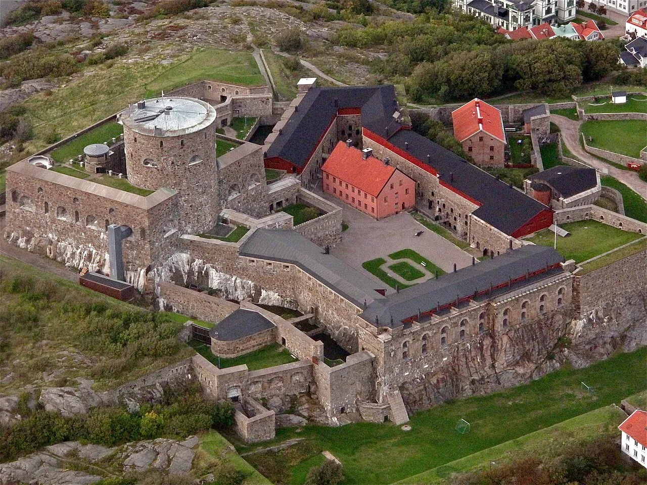
Carlsten (Swedish: Karlstens fästning) is a stone fortress located at Marstrand, on the western coast of Sweden. The fortress was built on the orders of King Carl X of Sweden following the Treaty of Roskilde, 1658 to protect the newly acquired province of Bohuslän from hostile attacks. The site of Marstrand was chosen because of its location and its access to an ice free port. The fortress was decommissioned as a permanent defense installation in 1882, but remained in military use until the early 1990s.
Source: Wikipedia · CC BY-SA 4.0
At a glance
- Built
- 1658
- Heritage designation
- governmental listed building complex
- Official website
- carlsten.se
Source: Wikidata
Photos of Carlsten Fortress
-

HasBS · CC BY-SA 4.0 -

Peterannlov · CC BY-SA 4.0 -

B. Stoopendaal Author: B. Stoopendaal Fecit Publisher: Onbekend / unknown · Public domain -

Lerche · Public domain -

Oregran · CC BY-SA 4.0


Climate of Carlsten Fortress
Best months for sightseeingBest months for sightseeing: June–August.
This month · November
A cold month
Day 6° · Night 2° · Rain 87 mm
- Hottest month
- July (day 21°)
- Coldest month
- February (night -4°)
- Wettest month
- November (87 mm)
- Driest month
- April (41 mm)
Bars: average monthly low and high temperature. Below: precipitation. Monthly averages for 1970–2000 at about 18 km resolution, adjusted for elevation. Highlighted months are mild and relatively dry. Source: WorldClim 2.1 (CC BY 4.0).
Show values as a table
| Month | Jan | Feb | Mar | Apr | May | Jun | Jul | Aug | Sep | Oct | Nov | Dec |
|---|---|---|---|---|---|---|---|---|---|---|---|---|
| Average high (°C) | 2° | 2° | 5° | 9° | 15° | 19° | 21° | 20° | 16° | 11° | 6° | 4° |
| Average low (°C) | -3° | -4° | -1° | 1° | 6° | 10° | 12° | 12° | 9° | 5° | 2° | -1° |
| Precipitation (mm) | 61 | 45 | 52 | 41 | 46 | 61 | 60 | 71 | 86 | 81 | 87 | 75 |
How to get to Carlsten Fortress
The nearest airport is Göteborg Landvetter Airport (GOT), 49 km to the southeast as the crow flies. The nearest large city is Gothenburg, 30 km to the southeast.
Airports
- Göteborg Landvetter Airport (GOT) Göteborg 49 kmsoutheast
- Trollhättan-Vänersborg Airport (THN) Trollhättan 66 kmnortheast
- Aalborg Airport (AAL) Aalborg 136 kmsouthwest
Nearby large cities
- Gothenburg Population: 608.5K 30 kmsoutheast
- Aalborg Population: 142.9K 136 kmsouthwest
- Jönköping Population: 112.8K 154 kmeast
- Aarhus Population: 285.3K 210 kmsouthwest
- Kristiansand Population: 117.2K 214 kmwest
Straight-line distances; road distances are longer. Airport data: OurAirports.
Day trips from Carlsten Fortress
Within 100 km: 11 historic and cultural sites, 90 natural sites, 440 lakes, rivers and coasts.
0–25 km146 places
- Hisingen Island 22 kmSE
- Håholmen Island 2 kmSW
- Halsholmen Island 3 kmE
- Brandholmen Island 22 kmN
25–60 km215 places
- Orust Island 31 kmN
- Skaftölandet Island 39 kmN
- Grötö Island 38 kmN
- Lindholmen Island 43 kmN
60–100 km180 places
- Guleskär Island 79 kmNW
- Ormudden Natural site 86 kmN
- Langerøn Natural site 79 kmSW
- Flatskär Island 64 kmSE
Straight-line distances.
Nearby attractions & nature
Everything nearby-
Marstrandsön Island, Västra Götaland County0.4 km W
-
Engelsmannen Island, Västra Götaland County1.6 km N
-
Ärholmen Island, Västra Götaland County1.7 km SW
-
Draget Natural site, Västra Götaland County2.2 km S
-
Geteryggen Island, Västra Götaland County2 km NE
-
Koön Island, Västra Götaland County2.2 km NE
-
Håholmen Island, Västra Götaland County2.3 km SW
-
Koholmen Island, Västra Götaland County2.9 km E
Nearest towns and villages
-
 Marstrand Village, Kungälv Municipality0.3 km NE
-
Marstrand Municipality, Kungälv Municipality1 km NW
-
 Åstol Village, Västra Götaland County3.4 km N
-
Marstrand socken Village, Marstrand1 km NW
Sources & licences
Data last updated: · 2 independent sources