Kalvsund
Located in Öckerö Municipality, Västra Götaland County Coordinates: 57°42′22″ N 11°41′08″ E
- Population
- 208
- 208
- Elevation
- 8 m
- above sea level
- Local time
- UTC+01:00
- Europe/Stockholm · UTC+01:00
- Airports
- GOT Göteborg Landvetter Airport36 km
- THN Trollhättan-Vänersborg Airport79 km
About Kalvsund
Kalvsund is a village. Location: Öckerö Municipality, Västra Götaland County. Population: 208. Elevation: 8 m.
Kalvsund is a locality situated in Öckerö Municipality, Västra Götaland County, Sweden with 221 inhabitants in 2010.
Source: Wikipedia · CC BY-SA 4.0
At a glance
- Area
- 26 ha
Source: Wikidata
Photos of Kalvsund
-
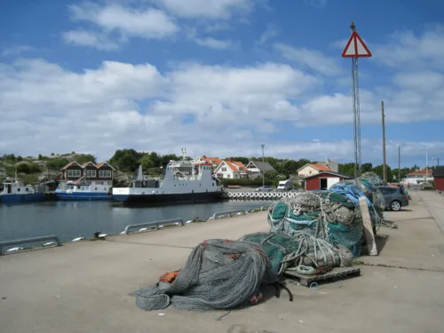
Öckerö Bulver · CC BY-SA 3.0 -
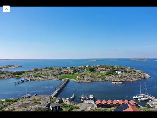
Långholmen Vivevilding · CC0


Population of Kalvsund over time
| 2015 | 208 | |
|---|---|---|
| 2016 | 204 | |
| 2017 | 206 | |
| 2018 | 208 | |
| 2019 | 231 | |
| 2020 | 245 | |
| 2023 | 233 |
Censuses and official estimates; source: Wikidata.
Climate of Kalvsund
Best months for sightseeingBest months for sightseeing: June–August.
This month · November
A cold month
Day 6° · Night 2° · Rain 75 mm
- Hottest month
- July (day 21°)
- Coldest month
- February (night -4°)
- Wettest month
- September (80 mm)
- Driest month
- April (42 mm)
Bars: average monthly low and high temperature. Below: precipitation. Monthly averages for 1970–2000 at about 18 km resolution, adjusted for elevation. Highlighted months are mild and relatively dry. Source: WorldClim 2.1 (CC BY 4.0).
Show values as a table
| Month | Jan | Feb | Mar | Apr | May | Jun | Jul | Aug | Sep | Oct | Nov | Dec |
|---|---|---|---|---|---|---|---|---|---|---|---|---|
| Average high (°C) | 2° | 2° | 5° | 9° | 16° | 19° | 21° | 20° | 16° | 11° | 6° | 4° |
| Average low (°C) | -3° | -4° | -1° | 2° | 6° | 10° | 13° | 12° | 9° | 5° | 2° | -1° |
| Precipitation (mm) | 62 | 43 | 49 | 42 | 46 | 59 | 59 | 68 | 80 | 75 | 75 | 75 |
How to get to Kalvsund
The nearest airport is Göteborg Landvetter Airport (GOT), 36 km to the east as the crow flies. The nearest large city is Gothenburg, 17 km to the east.
Airports
- Göteborg Landvetter Airport (GOT) Göteborg 36 kmeast
- Trollhättan-Vänersborg Airport (THN) Trollhättan 79 kmnortheast
- Aalborg Airport (AAL) Aalborg 130 kmsouthwest
Nearby large cities
- Gothenburg Population: 608.5K 17 kmeast
- Aalborg Population: 142.9K 129 kmsouthwest
- Jönköping Population: 112.8K 147 kmeast
- Aarhus Population: 285.3K 194 kmsouthwest
- Helsingborg Population: 104.2K 195 kmsouth
Straight-line distances; road distances are longer. Airport data: OurAirports.
Day trips from Kalvsund
Within 100 km: 12 historic and cultural sites, 80 natural sites, 392 lakes, rivers and coasts.
0–25 km146 places
- Hisingen Island 14 kmNE
- Håholmen Island 20 kmNW
- Halsholmen Island 19 kmN
- Hängesten Island 15 kmSE
25–60 km175 places
- Orust Island 51 kmN
- Grötö Island 59 kmN
- Bockön Island 33 kmSE
- Kråkholmen Island 31 kmSE
60–100 km163 places
- Skaftölandet Island 60 kmN
- Guleskär Island 100 kmN
- Lindholmen Island 63 kmN
- Langerøn Natural site 65 kmSW
Straight-line distances.
Nearby attractions & nature
Everything nearby-
Fjärholmen Island, Västra Götaland County1.3 km NW
-
Bårholmen Island, Västra Götaland County1.6 km NW
-
Öckerö Island, Västra Götaland County2.5 km W
-
Hönö Island, Västra Götaland County3 km SW
-
Lilla Rävholmen Island, Västra Götaland County3.8 km NW
-
Lilla Måvholmen Island, Västra Götaland County3.8 km SE
Sources & licences
Data last updated: · 2 independent sources