- Population
- 4,052
- 4.1K
- Elevation
- 84 m
- above sea level
- Local time
- UTC+01:00
- Europe/Stockholm · UTC+01:00
- Airports
- THN Trollhättan-Vänersborg Airport36 km
- GOT Göteborg Landvetter Airport78 km
About Vara
Vara is a city. Location: Vara Municipality, Västra Götaland County. Population: 4,052. Elevation: 84 m.
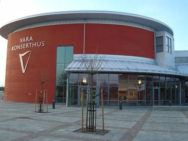
Vara is a locality and the seat of Vara Municipality, Västra Götaland County, Sweden with 4,235 inhabitants in 2019. Notable landmarks include the concert hall, the artwork on the train station called Blue Orange, Bengtssonska granary, and a folk high school.
Source: Wikipedia · CC BY-SA 4.0
At a glance
- Area
- 3.8 km²
Source: Wikidata
Photos of Vara
-

Johan Jönsson · CC BY-SA 4.0 -

Fanny S Forsdik · CC BY-SA 3.0 -

Bjoertvedt · CC BY-SA 4.0 -

Henk Lindeboom/ Anefo · CC0 -

Johan Jönsson · CC BY-SA 4.0


Population of Vara over time
| 2015 | 4,052 | |
|---|---|---|
| 2016 | 4,080 | |
| 2017 | 4,126 | |
| 2018 | 4,196 | |
| 2019 | 4,235 | |
| 2020 | 4,426 | |
| 2023 | 4,432 |
Censuses and official estimates; source: Wikidata.
Climate of Vara
Best months for sightseeingBest months for sightseeing: June–August.
This month · November
A cold month
Day 5° · Night 0° · Rain 66 mm
- Hottest month
- July (day 21°)
- Coldest month
- February (night -5°)
- Wettest month
- September (74 mm)
- Driest month
- February (34 mm)
Bars: average monthly low and high temperature. Below: precipitation. Monthly averages for 1970–2000 at about 18 km resolution, adjusted for elevation. Highlighted months are mild and relatively dry. Source: WorldClim 2.1 (CC BY 4.0).
Show values as a table
| Month | Jan | Feb | Mar | Apr | May | Jun | Jul | Aug | Sep | Oct | Nov | Dec |
|---|---|---|---|---|---|---|---|---|---|---|---|---|
| Average high (°C) | 1° | 1° | 4° | 9° | 16° | 19° | 21° | 21° | 15° | 10° | 5° | 2° |
| Average low (°C) | -4° | -5° | -2° | 1° | 6° | 9° | 11° | 10° | 7° | 4° | 0° | -3° |
| Precipitation (mm) | 47 | 34 | 39 | 38 | 44 | 63 | 64 | 66 | 74 | 68 | 66 | 54 |
How to get to Vara
The nearest airport is Trollhättan-Vänersborg Airport (THN), 36 km to the west as the crow flies. For international flights: Göteborg Landvetter Airport (GOT) (78 km). The nearest large city is Gothenburg, 85 km to the southwest.
Airports
- Trollhättan-Vänersborg Airport (THN) Trollhättan 36 kmwest
- Göteborg Landvetter Airport (GOT) Göteborg 78 kmsouthwest
- Jönköping Airport (JKG) Jönköping 87 kmsoutheast
Nearby large cities
- Gothenburg Population: 608.5K 85 kmsouthwest
- Jönköping Population: 112.8K 89 kmsoutheast
- Örebro Population: 156K 172 kmnortheast
- Oslo Population: 1.1M 223 kmnorthwest
- Aalborg Population: 142.9K 226 kmsouthwest
Straight-line distances; road distances are longer. Airport data: OurAirports.
Day trips from Vara
Within 100 km: 11 historic and cultural sites, 55 natural sites, 293 lakes, rivers and coasts.
0–25 km1 place
- Lekåsa kyrka Attraction 14 kmS
25–60 km12 places
- Kållandsö Island 46 kmN
- Lilla Eken Island 53 kmN
- Långö Island 40 kmN
- Klitt Island 42 kmN
60–100 km346 places
- Hisingen Island 84 kmSW
- Orust Island 78 kmW
- Skaftölandet Island 88 kmW
- Visingsö Island 85 kmE
Straight-line distances.
Sources & licences
Data last updated: · 2 independent sources