- Elevation
- 1,501 m
- above sea level
- Local time
- UTC+01:00
- Europe/Zurich · UTC+01:00
- Airports
- BRN Bern Airport70 km
- GVA Geneva International Airport70 km
About Lac Rond
Lac Rond is a lake. Location: Corbeyrier, Aigle District. Elevation: 1,501 m. The best months to visit are July–August. The nearest airport is Bern Airport (70 km). Nearby sights include Lac Pourri and Sex des Placettes.
Photos of Lac Rond
-
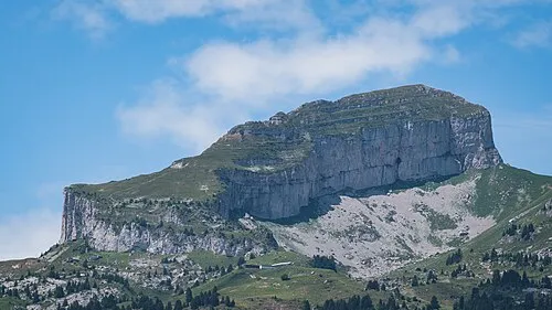
Tour d'Aï Christian David · CC BY-SA 4.0 -
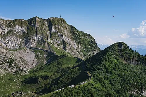
Rochers de Naye Christian David · CC BY-SA 4.0


Climate of Lac Rond
Best months for sightseeingBest months for sightseeing: July–August.
This month · November
A wet month
Day 3° · Night -3° · Rain 115 mm
- Hottest month
- July (day 18°)
- Coldest month
- January (night -7°)
- Wettest month
- June (136 mm)
- Driest month
- March (90 mm)
Bars: average monthly low and high temperature. Below: precipitation. Monthly averages for 1970–2000 at about 18 km resolution, adjusted for elevation. Highlighted months are mild and relatively dry. Source: WorldClim 2.1 (CC BY 4.0).
Show values as a table
| Month | Jan | Feb | Mar | Apr | May | Jun | Jul | Aug | Sep | Oct | Nov | Dec |
|---|---|---|---|---|---|---|---|---|---|---|---|---|
| Average high (°C) | -1° | 1° | 4° | 7° | 12° | 15° | 18° | 18° | 14° | 9° | 3° | 0° |
| Average low (°C) | -7° | -6° | -4° | -2° | 3° | 6° | 8° | 8° | 5° | 1° | -3° | -6° |
| Precipitation (mm) | 102 | 105 | 90 | 98 | 111 | 136 | 115 | 115 | 105 | 109 | 115 | 113 |
How to get to Lac Rond
The nearest airport is Bern Airport (BRN), 70 km to the northeast as the crow flies. For international flights: Geneva International Airport (GVA) (70 km). The nearest large city is Lausanne, 31 km to the northwest.
Airports
- Bern Airport (BRN) Bern 70 kmnortheast
- Geneva International Airport (GVA) Geneva 70 kmwest
- Annecy Meythet airport (NCY) Annecy 86 kmsouthwest
Nearby large cities
- Lausanne Population: 139.1K 31 kmnorthwest
- Geneva Population: 201.7K 69 kmwest
- Bern Population: 121.6K 71 kmnortheast
- Besançon Population: 128.4K 121 kmnorthwest
- Basel Population: 177.6K 137 kmnorth
Straight-line distances; road distances are longer. Airport data: OurAirports.
Day trips from Lac Rond
Within 100 km: 150 historic and cultural sites, 4,158 natural sites, 540 lakes, rivers and coasts.
0–25 km479 places
- Ile de Salagnon Island 10 kmNW
- Lac de Fully Lake 25 kmS
- Lac de Derborence Lake 21 kmSE
- Arnensee Lake 17 kmE
25–60 km1,810 places
- Ile d'Ogoz Island 35 kmN
- Schwarzsee Lake 38 kmNE
- Oeschinen Lake Lake 57 kmE
- Lac de la Gruyère Lake 31 kmN
60–100 km2,559 places
- Kleiner Bremgartenwald Mountain 73 kmNE
- Strandbad Neuhaus Beach 71 kmNE
- Strandbad Manor Farm Beach 71 kmNE
- Strandbad Leissigen Beach 66 kmNE
Straight-line distances.
Nearest towns and villages
-
Villeneuve (VD) Municipality, Aigle District2.6 km NW
-
Leysin Municipality, Aigle District4.2 km S
-
Veytaux Municipality, Riviera-Pays-d'Enhaut District4.9 km NW
-
Corbeyrier Village, Corbeyrier5.1 km SW
-
Villeneuve Village, Villeneuve (VD)5.4 km W
-
Leysin Village, Leysin5.4 km S
Nearby attractions & nature
Everything nearby-
Lac Pourri Lake, Corbeyrier0.5 km S
-
Sex des Placettes Mountain, Corbeyrier1 km E
-
Tour d'Aï Mountain, Leysin1.9 km S
-
Lac de Nervaux Lake, Corbeyrier1.6 km SW
-
Tour de Mayen Mountain, Leysin1.8 km SE
-
Sex du Parc aux Feyes Mountain, Corbeyrier2.2 km SW
-
Lac Segray Lake, Leysin2 km SE
-
Tour de Famelon Mountain, Leysin2.2 km E
Sources & licences
Data last updated: