Vallée de Joux
Located in Canton of Vaud, Switzerland Coordinates: 46°36′00″ N 6°15′00″ E
- Elevation
- 1,145 m
- above sea level
- Local time
- UTC+01:00
- Europe/Zurich · UTC+01:00
- Airports
- GVA Geneva International Airport42 km
- NCY Annecy Meythet airport75 km
About Vallée de Joux
Vallée de Joux is a natural site. Location: Canton of Vaud, Switzerland. The best months to visit are July–August. The nearest airport is Geneva International Airport (42 km). Nearby sights include Mont Tendre and Grand Cunay.
Photos of Vallée de Joux
-
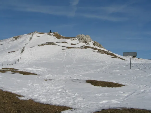
Mont Tendre Auteur: Delley Sébastien Original uploader was Seb65 at fr.wikipedia · CC BY-SA 1.0

Climate of Vallée de Joux
Best months for sightseeingBest months for sightseeing: July–August.
This month · November
A wet month
Day 5° · Night -1° · Rain 140 mm
- Hottest month
- August (day 20°)
- Coldest month
- January (night -4°)
- Wettest month
- December (144 mm)
- Driest month
- March (106 mm)
Bars: average monthly low and high temperature. Below: precipitation. Monthly averages for 1970–2000 at about 18 km resolution, adjusted for elevation. Highlighted months are mild and relatively dry. Source: WorldClim 2.1 (CC BY 4.0).
Show values as a table
| Month | Jan | Feb | Mar | Apr | May | Jun | Jul | Aug | Sep | Oct | Nov | Dec |
|---|---|---|---|---|---|---|---|---|---|---|---|---|
| Average high (°C) | 1° | 2° | 5° | 8° | 13° | 16° | 19° | 20° | 16° | 11° | 5° | 2° |
| Average low (°C) | -4° | -4° | -2° | 0° | 5° | 8° | 10° | 10° | 7° | 4° | -1° | -3° |
| Precipitation (mm) | 129 | 127 | 106 | 108 | 120 | 129 | 110 | 108 | 117 | 123 | 140 | 144 |
How to get to Vallée de Joux
The nearest airport is Geneva International Airport (GVA), 42 km to the south as the crow flies. The nearest large city is Lausanne, 31 km to the east.
Airports
- Geneva International Airport (GVA) Geneva 42 kmsouth
- Annecy Meythet airport (NCY) Annecy 75 kmsouth
- Dole Tavaux Airport (DLE) Dole 79 kmnorthwest
Nearby large cities
- Lausanne Population: 139.1K 31 kmeast
- Geneva Population: 201.7K 45 kmsouth
- Besançon Population: 128.4K 74 kmnorth
- Bern Population: 121.6K 99 kmnortheast
- Dijon Population: 159.9K 123 kmnorthwest
Straight-line distances; road distances are longer. Airport data: OurAirports.
Day trips from Vallée de Joux
Within 100 km: 190 historic and cultural sites, 1,810 natural sites, 338 lakes, rivers and coasts.
0–25 km63 places
- Lac de Joux Lake 5 kmNE
- Lake Leman Lake 25 kmSE
- Lac Brenet Lake 10 kmNE
- Lac Aubonne Lake 13 kmSE
25–60 km428 places
- Ile de Salagnon Island 52 kmE
- Lake Neuchâtel Lake 60 kmNE
- Lac des Joncs Lake 54 kmE
- Lac des Taillères Lake 48 kmNE
60–100 km1,847 places
- Kleiner Bremgartenwald Mountain 99 kmNE
- Sankt Petersinsel Island 86 kmNE
- Ile d'Ogoz Island 66 kmE
- Lake Wohlen Lake 91 kmNE
Straight-line distances.
Nearest towns and villages
-
Le Chenit Village, Le Chenit1.7 km NW
-
Sur le Crêt Village, Le Chenit0.8 km NE
-
L'Orient Village, Le Chenit0.8 km W
-
Pièce chez Marc Village, Le Chenit1.2 km E
-
Les Fûves Village, Le Chenit1.2 km NE
-
La Mollerie Village, Le Chenit1.4 km N
Nearby attractions & nature
Everything nearby-
Mont Tendre Mountain, L'Abbaye4.6 km E
-
Grand Cunay Mountain, Bière3.6 km SE
-
Petit Cunay Mountain, Bière4.6 km SE
-
Monts de Bière Mountain, Gimel4.8 km S
-
Crêt de Mondisé Mountain, Bière5.5 km SE
-
Grand Crêt Mountain, Switzerland6.8 km N
-
Le Risel Mountain, Montricher6.8 km E
-
Lac de Joux Lake, Switzerland5.5 km NE
Sources & licences
Data last updated: