- Elevation
- 1,291 m
- above sea level
- Local time
- UTC+01:00
- Europe/Zurich · UTC+01:00
- Airports
- ZRH Zürich Airport36 km
- ACH Sankt Gallen Altenrhein Airport47 km
About Schnebelhorn
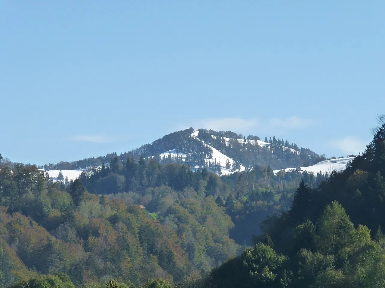
Schnebelhorn is a mountain. Location: Fischenthal, Hinwil District. Elevation: 1,291 m.
The Schnebelhorn is a mountain located near Fischenthal in the Töss Valley, between the cantons of Zurich (Oberland region) and St. Gallen (Toggenburg). At 1,291 m (4,236 ft), it is the highest summit of the canton of Zurich. Various trails lead to the summit from all sides. Most of the massif is covered by forests.
Source: Wikipedia · CC BY-SA 4.0
At a glance
- Topographic prominence
- 112 m
Source: Wikidata
Photos of Schnebelhorn
-

Jason Conzett · CC BY-SA 4.0 -

Jason Conzett · CC BY-SA 4.0 -

Uwelino · CC BY-SA 4.0 -

Uwelino · CC BY-SA 4.0 -

Markus Plüss · CC BY 3.0


Climate of Schnebelhorn
Best months for sightseeingBest months for sightseeing: July–August.
This month · November
A wet month
Day 3° · Night -3° · Rain 103 mm
- Hottest month
- July (day 18°)
- Coldest month
- January (night -7°)
- Wettest month
- July (161 mm)
- Driest month
- January (73 mm)
Bars: average monthly low and high temperature. Below: precipitation. Monthly averages for 1970–2000 at about 18 km resolution, adjusted for elevation. Highlighted months are mild and relatively dry. Source: WorldClim 2.1 (CC BY 4.0).
Show values as a table
| Month | Jan | Feb | Mar | Apr | May | Jun | Jul | Aug | Sep | Oct | Nov | Dec |
|---|---|---|---|---|---|---|---|---|---|---|---|---|
| Average high (°C) | -2° | 0° | 5° | 8° | 13° | 16° | 18° | 18° | 14° | 9° | 3° | -1° |
| Average low (°C) | -7° | -7° | -4° | -1° | 3° | 6° | 8° | 8° | 5° | 1° | -3° | -6° |
| Precipitation (mm) | 73 | 85 | 82 | 99 | 117 | 155 | 161 | 151 | 111 | 94 | 103 | 92 |
How to get to Schnebelhorn
The nearest airport is Zürich Airport (ZRH), 36 km to the northwest as the crow flies. The nearest large city is Winterthur, 28 km to the northwest.
Airports
- Zürich Airport (ZRH) Zurich 36 kmnorthwest
- Sankt Gallen Altenrhein Airport (ACH) St. Gallen 47 kmeast
- Bodensee Airport Friedrichshafen (FDH) Friedrichshafen 56 kmnortheast
Nearby large cities
- Winterthur Population: 111.8K 28 kmnorthwest
- Zurich Population: 415.4K 33 kmwest
- Basel Population: 177.6K 109 kmwest
- Freiburg im Breisgau Population: 237.5K 113 kmnorthwest
- Bern Population: 121.6K 124 kmwest
Straight-line distances; road distances are longer. Airport data: OurAirports.
Day trips from Schnebelhorn
Within 100 km: 495 historic and cultural sites, 5,712 natural sites, 1,126 lakes, rivers and coasts.
0–25 km236 places
- Ufenau Island 19 kmSW
- Insel Lützelau Island 18 kmSW
- Schönenwerd Island 24 kmSW
- Seedamm Island 17 kmSW
25–60 km2,011 places
- Mainau Island 45 kmN
- Fahr Abbey Attraction 42 kmW
- Dominikanerinsel Konstanz Island 41 kmN
- Strandbad Steckborn Beach 37 kmN
60–100 km5,086 places
- Strandbad Brienz Beach 95 kmSW
- Mauesee-Insel Island 71 kmW
- Gamma-Inseli Island 67 kmW
- Lago Tremorgio Lake 96 kmS
Straight-line distances.
Nearest towns and villages
-
Grossegg Village, Fischenthal1.1 km NW
-
Hinter-Strahlegg Village, Fischenthal1.4 km W
-
Vorder-Strahlegg Village, Fischenthal1.7 km W
-
Burenboden Village, Fischenthal0.5 km W
-
Leutobel Village, Fischenthal1.5 km NW
-
Mosnang Municipality, Wahlkreis Toggenburg3.5 km NE
Nearby attractions & nature
Everything nearby-
Schindelberghöchi Mountain, Eschenbach (SG)0.8 km SE
-
Dägelschberg Mountain, Fischenthal1.2 km S
-
Schindelegg Mountain, Eschenbach (SG)1.2 km SE
-
Hübschegg Mountain, Fischenthal1.2 km SW
-
Warten Mountain, Fischenthal1.4 km W
-
Laubberg Mountain, Mosnang1.6 km NE
-
Hirzegg Mountain, Mosnang1.7 km N
-
Rossegg Mountain, Eschenbach (SG)2 km SE
More nature in Switzerland
-
 Hörnli Mountain, Fischenthal5.8 km NW
-
Chatzenböl Mountain, Fischenthal3.3 km NW
-
Hasenböl Mountain, Fischenthal3.5 km W
-
Johannenböl Mountain, Fischenthal4 km NW
-
Hinterhörnli Mountain, Fischenthal5.1 km NW
-
Wilgupf Mountain, Fischenthal5.4 km NW
Sources & licences
Data last updated: · 2 independent sources