- Elevation
- 33 m
- above sea level
- Local time
- UTC+01:00
- Europe/Amsterdam · UTC+01:00
- Airports
- MST Maastricht Aachen Airport22 km
- EIN Eindhoven Airport56 km
About Pepinusbrug
Pepinusbrug is a village. Location: Gemeente Echt-Susteren, Limburg. Elevation: 33 m.
Pepinusbrug is a hamlet south-east of Pey in the Dutch municipality Echt-Susteren. The name Pepinusbrug originates from a legend about Pepin of Herstal, who was the lord of the Frankish kingdom. According to this legend, he went on an annual pilgrimage from his hometown of Herstal to the monastery on Mount Petrus (nowadays known as Sint Odiliënberg), which was supposedly founded by saints Wiro of Roermond, Plechelmus, and Otgerus.
Source: Wikipedia · CC BY-SA 4.0
Climate of Pepinusbrug
Best months for sightseeingBest months for sightseeing: June–August.
This month · November
A cold month
Day 9° · Night 3° · Rain 64 mm
- Hottest month
- July (day 23°)
- Coldest month
- February (night 0°)
- Wettest month
- June (76 mm)
- Driest month
- April (45 mm)
Bars: average monthly low and high temperature. Below: precipitation. Monthly averages for 1970–2000 at about 18 km resolution, adjusted for elevation. Highlighted months are mild and relatively dry. Source: WorldClim 2.1 (CC BY 4.0).
Show values as a table
| Month | Jan | Feb | Mar | Apr | May | Jun | Jul | Aug | Sep | Oct | Nov | Dec |
|---|---|---|---|---|---|---|---|---|---|---|---|---|
| Average high (°C) | 5° | 6° | 10° | 13° | 18° | 21° | 23° | 23° | 19° | 14° | 9° | 7° |
| Average low (°C) | 0° | 0° | 2° | 4° | 8° | 11° | 13° | 13° | 10° | 7° | 3° | 2° |
| Precipitation (mm) | 61 | 49 | 62 | 45 | 62 | 76 | 67 | 57 | 61 | 59 | 64 | 68 |
How to get to Pepinusbrug
The nearest airport is Maastricht Aachen Airport (MST), 22 km to the southwest as the crow flies. The nearest large city is Maastricht, 31 km to the southwest.
Airports
- Maastricht Aachen Airport (MST) Maastricht 22 kmsouthwest
- Eindhoven Airport (EIN) Eindhoven 56 kmnorthwest
- Weeze (Niederrhein) Airport (NRN) Weeze 59 kmnorth
Nearby large cities
- Maastricht Population: 122.4K 31 kmsouthwest
- Venlo Population: 102K 36 kmnortheast
- Aachen Population: 265.2K 36 kmsouth
- Mönchengladbach Population: 261.7K 38 kmeast
- Eindhoven Population: 235.7K 50 kmnorthwest
Straight-line distances; road distances are longer. Airport data: OurAirports.
Day trips from Pepinusbrug
Within 100 km: 426 historic and cultural sites, 1,265 natural sites, 830 lakes, rivers and coasts.
0–25 km68 places
- Stokkemderbos Natural site 18 kmSW
- Solter Heide Natural site 19 kmW
- Sint-Martens-Heide Natural site 22 kmNW
- Pejensbos Natural site 24 kmSW
25–60 km581 places
- Île Monsin Island 52 kmSW
- Île de Franche Garenne Island 46 kmS
- Lac de la Gileppe Lake 56 kmS
- Lac d'Eupen Lake 53 kmS
60–100 km1,872 places
- Île du Moulin Island 62 kmS
- Vijvers van Bellefroid Lake 88 kmW
- Lac de Robertville Lake 72 kmS
- Wijngaardberg Mountain 83 kmW
Straight-line distances.
Nearby attractions & nature
Everything nearby-
Saeffeler-beek River, Germany7.2 km SW
-
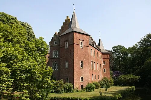 Schloß Elsum Historic site, Wassenberg15 km E
-
Émissaire River, Limburg Province8.3 km NW
-
Bosbeek River, Limburg Province8.9 km W
-
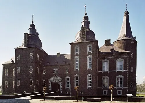 Kasteel Hoensbroek Historic site, Gemeente Heerlen19 km S
-
Noordplas Beach, Roermond Municipality13 km N
Sources & licences
Data last updated: · 2 independent sources