- Population
- 1,765
- 1.8K
- Elevation
- 32 m
- above sea level
- Local time
- UTC+01:00
- Europe/Amsterdam · UTC+01:00
- Airports
- MST Maastricht Aachen Airport33 km
- EIN Eindhoven Airport48 km
About Beegden
Beegden is a village. Location: Gemeente Maasgouw, Limburg. Population: 1,765. Elevation: 32 m.
Beegden (Dutch pronunciation: [ˈbeːɣdə(n)]; Limburgish: Bieëgdje [ˈbiəɣdʒə]) is a village in the Dutch province of Limburg. It is a part of the municipality of Maasgouw, and is located about 6 km west of Roermond. Until 1991, Beegden was a separate municipality. During that year the village became part of the municipality of Heel en Panheel. In 2007 the municipality of Heel en Panheel, including Beegden, became part of the new municipality of Maasgouw. The town currently has about 1800 inhabitants.
Source: Wikipedia · CC BY-SA 4.0
Climate of Beegden
Best months for sightseeingBest months for sightseeing: June–August.
This month · November
A cold month
Day 9° · Night 3° · Rain 65 mm
- Hottest month
- July (day 23°)
- Coldest month
- February (night 0°)
- Wettest month
- June (73 mm)
- Driest month
- April (44 mm)
Bars: average monthly low and high temperature. Below: precipitation. Monthly averages for 1970–2000 at about 18 km resolution, adjusted for elevation. Highlighted months are mild and relatively dry. Source: WorldClim 2.1 (CC BY 4.0).
Show values as a table
| Month | Jan | Feb | Mar | Apr | May | Jun | Jul | Aug | Sep | Oct | Nov | Dec |
|---|---|---|---|---|---|---|---|---|---|---|---|---|
| Average high (°C) | 5° | 6° | 10° | 13° | 19° | 21° | 23° | 23° | 19° | 14° | 9° | 7° |
| Average low (°C) | 0° | 0° | 2° | 4° | 8° | 11° | 13° | 12° | 10° | 7° | 3° | 1° |
| Precipitation (mm) | 62 | 48 | 63 | 44 | 63 | 73 | 66 | 57 | 62 | 60 | 65 | 69 |
How to get to Beegden
The nearest airport is Maastricht Aachen Airport (MST), 33 km to the south as the crow flies. The nearest large city is Venlo, 27 km to the northeast.
Airports
- Maastricht Aachen Airport (MST) Maastricht 33 kmsouth
- Eindhoven Airport (EIN) Eindhoven 48 kmnorthwest
- Weeze (Niederrhein) Airport (NRN) Weeze 48 kmnorth
Nearby large cities
- Venlo Population: 102K 27 kmnortheast
- Mönchengladbach Population: 261.7K 37 kmeast
- Maastricht Population: 122.4K 41 kmsouthwest
- Eindhoven Population: 235.7K 42 kmnorthwest
- Krefeld Population: 238K 47 kmeast
Straight-line distances; road distances are longer. Airport data: OurAirports.
Nearby attractions & nature
Everything nearby-
Noordplas Beach, Roermond Municipality3.5 km E
-
Itterbeek River, Belgium5.5 km SW
-
Witbeek River, Limburg Province6.9 km SW
-
Galgenberg Mountain, Niederkrüchten11 km E
-
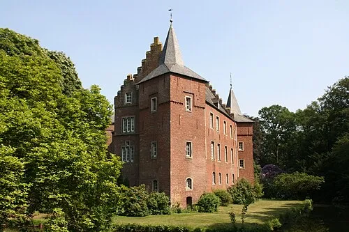 Schloß Elsum Historic site, Wassenberg17 km SE
-
Vogelsberg Mountain, Niederkrüchten13 km E
Sources & licences
Data last updated: · 2 independent sources