Broekhuizen
Located in Horst aan de Maas Municipality, Limburg Coordinates: 51°29′09″ N 6°09′50″ E
- Population
- 610
- 610
- Elevation
- 20 m
- above sea level
- Local time
- UTC+01:00
- Europe/Amsterdam · UTC+01:00
- Airports
- NRN Weeze (Niederrhein) Airport13 km
- DUS Düsseldorf Airport47 km
About Broekhuizen
Broekhuizen is a village. Location: Horst aan de Maas Municipality, Limburg. Population: 610. Elevation: 20 m. The best months to visit are June–August. The nearest airport is Weeze (Niederrhein) Airport (13 km). Nearby sights include Kasteel Arcen and castle Arcen.
Photos of Broekhuizen
-
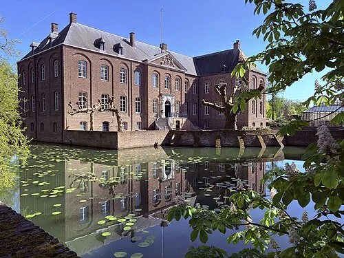
Kasteel Arcen Vincent van Zeijst · CC BY-SA 4.0 -
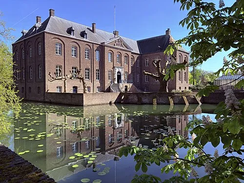
castle Arcen Vincent van Zeijst · CC BY-SA 4.0

Climate of Broekhuizen
Best months for sightseeingBest months for sightseeing: June–August.
This month · November
A cold month
Day 9° · Night 3° · Rain 66 mm
- Hottest month
- July (day 23°)
- Coldest month
- February (night 0°)
- Wettest month
- June (73 mm)
- Driest month
- April (45 mm)
Bars: average monthly low and high temperature. Below: precipitation. Monthly averages for 1970–2000 at about 18 km resolution, adjusted for elevation. Highlighted months are mild and relatively dry. Source: WorldClim 2.1 (CC BY 4.0).
Show values as a table
| Month | Jan | Feb | Mar | Apr | May | Jun | Jul | Aug | Sep | Oct | Nov | Dec |
|---|---|---|---|---|---|---|---|---|---|---|---|---|
| Average high (°C) | 5° | 6° | 10° | 14° | 19° | 21° | 23° | 23° | 19° | 14° | 9° | 6° |
| Average low (°C) | 0° | 0° | 2° | 4° | 8° | 11° | 13° | 12° | 10° | 7° | 3° | 1° |
| Precipitation (mm) | 62 | 47 | 62 | 45 | 62 | 73 | 68 | 58 | 62 | 61 | 66 | 69 |
How to get to Broekhuizen
The nearest airport is Weeze (Niederrhein) Airport (NRN), 13 km to the north as the crow flies. The nearest large city is Venlo, 13 km to the south.
Airports
- Weeze (Niederrhein) Airport (NRN) Weeze 13 kmnorth
- Düsseldorf Airport (DUS) Düsseldorf 47 kmsoutheast
- Eindhoven Airport (EIN) Eindhoven 55 kmwest
Nearby large cities
- Venlo Population: 102K 13 kmsouth
- Krefeld Population: 238K 32 kmsoutheast
- Moers Population: 103.5K 33 kmeast
- Mönchengladbach Population: 261.7K 39 kmsoutheast
- Duisburg Population: 504.4K 42 kmeast
Straight-line distances; road distances are longer. Airport data: OurAirports.
Day trips from Broekhuizen
Within 100 km: 367 historic and cultural sites, 662 natural sites, 567 lakes, rivers and coasts.
0–25 km75 places
- Kasteel Arcen Historic site 2 kmSE
- Schrolik Lake 16 kmS
- Poelvenn Lake 16 kmSE
- Nettbruch Lake 22 kmS
25–60 km409 places
- Veldhoven Bos Natural site 50 kmSW
- Varkensbos Natural site 53 kmSW
- Solter Heide Natural site 56 kmSW
- Sint-Martens-Heide Natural site 51 kmSW
60–100 km1,112 places
- Île Monsin Island 99 kmS
- Île de Franche Garenne Island 94 kmS
- Lac d'Eupen Lake 96 kmS
- Wetsberg Mountain 90 kmSW
Straight-line distances.
Nearby attractions & nature
Everything nearby-
Kasteel Arcen Historic site, Venlo Municipality2.2 km SE
-
castle Arcen Historic site, Arcen2.2 km SE
-
Dikkenberg Mountain, Bergen Municipality5.7 km N
-
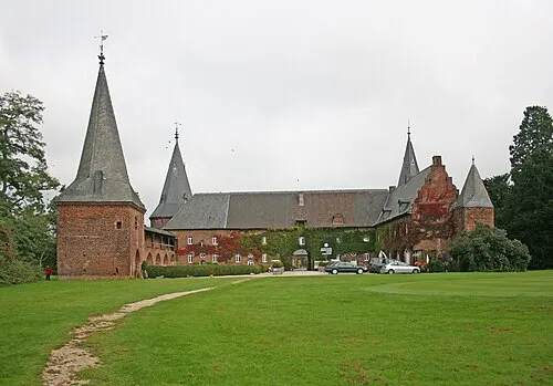 Schloß Haag Historic site, Geldern9 km NE
-
Leitgraben River, North Rhine-Westphalia6.9 km SE
-
Sint Martinsberg Mountain, Horst aan de Maas Municipality11 km W
Other cities and towns in Horst aan de Maas Municipality
-
Grubbenvorst Village, Horst aan de Maas Municipality7.4 km S
-
 Melderslo Village, Horst aan de Maas Municipality6 km SW
-
Tienray Village, Horst aan de Maas Municipality5 km W
-
Meerlo Village, Horst aan de Maas Municipality6.3 km NW
-
Hegelsom Village, Horst aan de Maas Municipality10 km SW
-
Ooijen Village, Horst aan de Maas Municipality2.6 km N
Sources & licences
Data last updated: