Karyol Dağı
Located in Yusufeli İlçesi, Artvin Province Coordinates: 40°49′00″ N 41°49′00″ E
- Elevation
- 2,138 m
- above sea level
- Local time
- UTC+03:00
- Europe/Istanbul · UTC+03:00
- Airports
- BUS Alexander Kartveli Batumi International Airport90 km
- RZV Rize–Artvin Airport91 km
About Karyol Dağı
Karyol Dağı is a mountain. Location: Yusufeli İlçesi, Artvin Province. Elevation: 2,138 m. The best months to visit are July–August. The nearest airport is Alexander Kartveli Batumi International Airport (90 km). Nearby sights include Kariyer Tepesi and Öküz Dağı.
Climate of Karyol Dağı
Best months for sightseeingBest months for sightseeing: July–August.
This month · November
A cold month
Day 4° · Night -5° · Rain 54 mm
Better nearby cities in November
- Cizre · 389 km south20°
- Hottest month
- July (day 22°)
- Coldest month
- January (night -12°)
- Wettest month
- June (67 mm)
- Driest month
- September (35 mm)
Bars: average monthly low and high temperature. Below: precipitation. Monthly averages for 1970–2000 at about 18 km resolution, adjusted for elevation. Highlighted months are mild and relatively dry. Source: WorldClim 2.1 (CC BY 4.0).
Show values as a table
| Month | Jan | Feb | Mar | Apr | May | Jun | Jul | Aug | Sep | Oct | Nov | Dec |
|---|---|---|---|---|---|---|---|---|---|---|---|---|
| Average high (°C) | -4° | -2° | 2° | 9° | 14° | 18° | 22° | 22° | 18° | 11° | 4° | -2° |
| Average low (°C) | -12° | -11° | -7° | -1° | 3° | 5° | 9° | 9° | 5° | 0° | -5° | -9° |
| Precipitation (mm) | 43 | 41 | 40 | 55 | 66 | 67 | 43 | 36 | 35 | 57 | 54 | 49 |
How to get to Karyol Dağı
The nearest airport is Alexander Kartveli Batumi International Airport (BUS), 90 km to the north as the crow flies. The nearest large city is Erzurum, 111 km to the southwest.
Airports
- Alexander Kartveli Batumi International Airport (BUS) Batumi 90 kmnorth
- Rize–Artvin Airport (RZV) Rize 91 kmnorthwest
- Erzurum International Airport (ERZ) Erzurum 110 kmsouthwest
Nearby large cities
- Erzurum Population: 767.8K 111 kmsouthwest
- Rize Population: 119.8K 111 kmwest
- Ağrı Population: 124.5K 161 kmsoutheast
- Trabzon Population: 244.1K 177 kmwest
- Iğdır Population: 101.7K 214 kmsoutheast
Straight-line distances; road distances are longer. Airport data: OurAirports.
Nearest towns and villages
Nearby attractions & nature
Everything nearby-
Kariyer Tepesi Mountain, Yusufeli İlçesi1.9 km W
-
Öküz Dağı Mountain, Yusufeli İlçesi4.8 km SW
-
Aslanmendur Tepesi Mountain, Yusufeli İlçesi6.4 km NE
-
Kürbaşı Tepesi Mountain, Olur İlçesi5.5 km E
-
Pasha Tepesi Mountain, Oltu İlçesi6.4 km SE
-
Sağısol Tepesi Mountain, Yusufeli İlçesi7.9 km NW
-
Aslanmendur Tepesi Mountain, Yusufeli İlçesi6.9 km NE
-
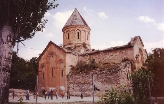 Ishkhani Monastery Attraction, Yusufeli İlçesi6.8 km SW
Sources & licences
Data last updated: · 2 independent sources