- Population
- 50
- 50
- Elevation
- 1,551 m
- above sea level
- Local time
- UTC+03:00
- Europe/Istanbul · UTC+03:00
- Airports
- ERC Erzincan Airport48 km
- ERZ Erzurum International Airport95 km
About Saraycık
Saraycık is a village. Location: Çayırlı İlçesi, Erzincan Province. Population: 50. Elevation: 1,551 m. The best months to visit are May–June, September. The nearest airport is Erzincan Airport (48 km). Nearby sights include Saraycık Çayı and Mans Deresi.
Climate of Saraycık
Best months for sightseeingBest months for sightseeing: May–June, September.
This month · November
A cold month
Day 9° · Night 0° · Rain 68 mm
Better nearby cities in November
- Viranşehir · 285 km south18°
- Kızıltepe · 291 km south19°
- Cizre · 328 km southeast20°
- Hottest month
- August (day 30°)
- Coldest month
- January (night -8°)
- Wettest month
- April (88 mm)
- Driest month
- August (10 mm)
Bars: average monthly low and high temperature. Below: precipitation. Monthly averages for 1970–2000 at about 18 km resolution, adjusted for elevation. Highlighted months are mild and relatively dry. Source: WorldClim 2.1 (CC BY 4.0).
Show values as a table
| Month | Jan | Feb | Mar | Apr | May | Jun | Jul | Aug | Sep | Oct | Nov | Dec |
|---|---|---|---|---|---|---|---|---|---|---|---|---|
| Average high (°C) | 0° | 1° | 6° | 14° | 20° | 25° | 30° | 30° | 26° | 18° | 9° | 2° |
| Average low (°C) | -8° | -7° | -2° | 4° | 8° | 11° | 14° | 14° | 10° | 5° | 0° | -5° |
| Precipitation (mm) | 59 | 56 | 66 | 88 | 86 | 42 | 12 | 10 | 17 | 57 | 68 | 67 |
How to get to Saraycık
The nearest airport is Erzincan Airport (ERC), 48 km to the west as the crow flies. The nearest large city is Erzincan, 51 km to the west.
Airports
- Erzincan Airport (ERC) Erzincan 48 kmwest
- Erzurum International Airport (ERZ) Erzurum 95 kmeast
- Bingöl Airport (BGG) Bingöl 111 kmsoutheast
Nearby large cities
- Erzincan Population: 150.7K 51 kmwest
- Erzurum Population: 767.8K 103 kmeast
- Bingoel Population: 128.9K 105 kmsouth
- Trabzon Population: 244.1K 140 kmnorth
- Rize Population: 119.8K 143 kmnorth
Straight-line distances; road distances are longer. Airport data: OurAirports.
Day trips from Saraycık
Within 100 km: 7 historic and cultural sites, 846 natural sites, 477 lakes, rivers and coasts.
0–25 km34 places
- Şengül Dağı Mountain 20 kmS
- Çiçekli Dağ Mountain 19 kmW
- Karakaya Dağı Mountain 14 kmSW
- Güllü Dağı Mountain 25 kmNE
25–60 km403 places
- Salyazı Barajı Lake 58 kmNW
- Yedi Göller Lake 29 kmW
- Medek Gölleri Lake 59 kmE
- Hıdır Gölü Lake 46 kmE
60–100 km893 places
- Özlüce Barajı Lake 68 kmS
- Cayit Barajı Lake 85 kmS
- Koç Gölü Lake 75 kmSW
- Çakır Gölü Lake 95 kmN
Straight-line distances.
Nearby attractions & nature
Everything nearby-
Saraycık Çayı River, Erzincan Province4.8 km NE
-
Mans Deresi River, Erzincan Province5.5 km NW
-
Çilingir Deresi River, Erzincan Province5.5 km NW
-
Pülk Çayı River, Erzincan Province8.6 km N
-
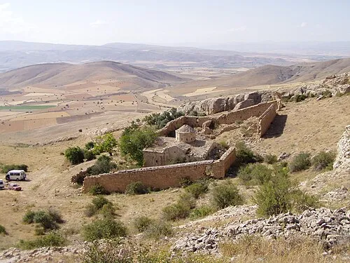 Aprank Monastery Attraction, Tercan İlçesi22 km SE
-
Karakaya Dağı Mountain, Çayırlı İlçesi14 km SW
Sources & licences
Data last updated: