Osmaniye Province
Local name: Osmaniye ili
Located in Turkey Coordinates: 37°14′07″ N 36°14′45″ E
- Population
- 559,405
- 559.4K
- Elevation
- 235 m
- above sea level
- Local time
- UTC+03:00
- Europe/Istanbul · UTC+03:00
- Places inside
- 47
- listed under Osmaniye Province
About Osmaniye Province
Osmaniye Province is a region. Location: Turkey. Population: 559,405.
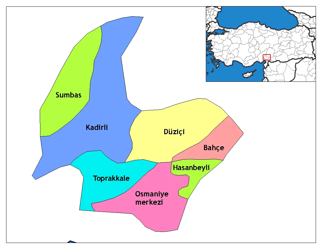
Osmaniye Province (Turkish: Osmaniye ili) is a province in south-central Turkey. It was named Cebel-i Bereket (lit. 'Fertile Mountain') in the early republic until 1933, when it was incorporated into Adana Province. It was made a province again in 1996. Its area is 3,320 km2, and its population is 559,405 (2022). The province is situated in Çukurova, a geographical, economical and cultural region. The capital of the province is Osmaniye. Other major towns include Kadirli and Düziçi.
Read more on Wikipedia Text: Wikipedia contributors · CC BY-SA 4.0 · shortened
At a glance
- Area
- 3,767 km²
Source: Wikidata
In comparison
- 6 sights and natural places within 10 km Kara Tepe, Keşiş Suyu
- Listed here: River: 14, Municipality: 9, Village: 8, District: 7
Places in Osmaniye Province
47 places-
Kadirli İlçesi District118.1K
-
Düziçi İlçesi District79.4K
-
Bahçe İlçesi District21.1K
-
Toprakkale District20.7K
-
Sumbas İlçesi District15.1K
-
Hasanbeyli İlçesi District4.4K
-
Ada Tepe Mountain
-
Akçasu River
-
Arıklıkaş Göleti Lake
-
Ayvacık Village
-
Bahçe Bucağı Municipality
-
Çağlayan Dere River
-
Çakıroğlu Village
-
Çayır Suyu River
-
Çiçekli Dere River
-
Değirmendere Village
-
Düziçi Bucağı Municipality
-
Ekşiler Village
-
Gökelma Village
-
Gölcegez Pınarı Natural site
-
Hasanbeyli Bucağı Municipality
-
Kabaklı Dere River
-
Kabaklı Dere River
-
Kadirli Bucağı Municipality
-
Kaledibi Village
-
Kansız Dere River
-
Kaya Pınar Natural site
-
Kaypak Bucağı Municipality
-
Kesik Suyu River
-
Keşiş Suyu River
-
Killik Pınarı Natural site
-
Kışnazgözü Pınarı Natural site
-
Kötüsu Kaynağı Natural site
-
Küçük İntilli Village
-
Lülük Village
-
Osmaniye District
-
Sabun Suyu River
-
Savrun Çayı River
-
Savrun Çayı River
-
Soğuksu Pınarı Natural site
-
Sumbas Bucağı Municipality
-
Tahtasuyu River
-
Tecirli Bucağı Municipality
-
Toprakkale Bucağı Municipality
-
Yarpuz Bucağı Municipality
-
Yarpuz Çayı River
-
Yumurta Pınarı Natural site
Largest cities and towns
-
Osmaniye City, Osmaniye202.8K
-
Toprakkale City, Toprakkale8.6K
-
Kadirli City, Kadirli İlçesi70.2K
-
Yarpuz Village, Osmaniye1.9K
-
Hasanbeyli City, Hasanbeyli İlçesi6.3K
-
Kırmıtlı Village, Osmaniye890
-
Yazlamazlı Village, Düziçi İlçesi1.7K
-
Karagedik Village, Düziçi İlçesi884
Nature and heritage in Osmaniye Province
-
Bahadır Tepe Mountain, Osmaniye
-
Dumanlı Dağ Mountain, Düziçi İlçesi
-
Kelibik Tepesi Mountain, Osmaniye
-
Karakaya Tepesi Mountain, Osmaniye
-
Topçam Tepesi Mountain, Osmaniye
-
Dumanlı Dağı Mountain, Osmaniye
Other regions in Turkey
-
Hatay Province Region, Turkey82 km S
-
 Adana Province Region, Turkey90 km W
-
Erzin İlçesi District, Hatay Province32 km S
-
Ceyhan District, Adana Province41 km SW
-
Dörtyol İlçesi District, Hatay Province45 km S
-
Andırın İlçesi District, Kahramanmaraş Province40 km N
Sources & licences
Data last updated: · 2 independent sources