Marley Thatch Hill
Located in South Brent, South Hams District Coordinates: 50°25′39″ N 3°47′52″ W
- Elevation
- 192 m
- above sea level
- Local time
- UTC+00:00
- Europe/London · UTC+00:00
- Airports
- EXT Exeter International Airport44 km
- NQY Cornwall Airport Newquay85 km
About Marley Thatch Hill
Marley Thatch Hill is a mountain. Location: South Brent, South Hams District. Elevation: 192 m. The best months to visit are June–August. The nearest airport is Exeter International Airport (44 km). Nearby sights include Bowdown Cross and Diptford Downs.
Photos of Marley Thatch Hill
-
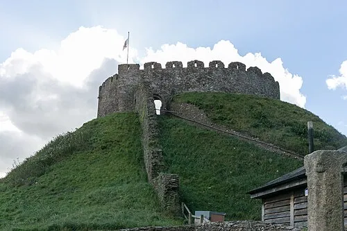
Totnes Castle Pymouss · CC BY-SA 4.0

Climate of Marley Thatch Hill
Best months for sightseeingBest months for sightseeing: June–August.
This month · November
A wet month
Day 11° · Night 5° · Rain 107 mm
- Hottest month
- July (day 19°)
- Coldest month
- February (night 2°)
- Wettest month
- December (124 mm)
- Driest month
- July (50 mm)
Bars: average monthly low and high temperature. Below: precipitation. Monthly averages for 1970–2000 at about 18 km resolution, adjusted for elevation. Highlighted months are mild and relatively dry. Source: WorldClim 2.1 (CC BY 4.0).
Show values as a table
| Month | Jan | Feb | Mar | Apr | May | Jun | Jul | Aug | Sep | Oct | Nov | Dec |
|---|---|---|---|---|---|---|---|---|---|---|---|---|
| Average high (°C) | 8° | 8° | 10° | 11° | 15° | 17° | 19° | 19° | 17° | 14° | 11° | 8° |
| Average low (°C) | 3° | 2° | 3° | 4° | 7° | 10° | 12° | 12° | 10° | 8° | 5° | 4° |
| Precipitation (mm) | 119 | 96 | 84 | 63 | 63 | 59 | 50 | 69 | 81 | 102 | 107 | 124 |
How to get to Marley Thatch Hill
The nearest airport is Exeter International Airport (EXT), 44 km to the northeast as the crow flies. For international flights: Cardiff International Airport (CWL) (112 km). The nearest large city is Plymouth, 25 km to the west.
Airports
- Exeter International Airport (EXT) Exeter, Devon 44 kmnortheast
- Cornwall Airport Newquay (NQY) Newquay 85 kmwest
- Cardiff International Airport (CWL) Cardiff 112 kmnorth
Nearby large cities
- Plymouth Population: 260.2K 25 kmwest
- Exeter Population: 130.7K 38 kmnortheast
- Cardiff Population: 372.1K 125 kmnorth
- Poole Population: 151.5K 132 kmeast
- Swansea Population: 300.4K 133 kmnorth
Straight-line distances; road distances are longer. Airport data: OurAirports.
Day trips from Marley Thatch Hill
Within 100 km: 195 historic and cultural sites, 922 natural sites, 119 lakes, rivers and coasts.
0–25 km243 places
- Burgh Island Island 18 kmSW
- Goodrington Sands Beach 16 kmE
- Oddicombe Beach Beach 21 kmE
- Babbacombe Beach Beach 21 kmE
25–60 km349 places
- Tregantle Beach Beach 35 kmW
- Lansallos Beach Beach 57 kmW
- Looe Island Island 48 kmW
- Mewstone Island 26 kmSW
60–100 km644 places
- Chesil Beach Beach 90 kmE
- Saunton Sands Beach 81 kmN
- Charmouth Beach Beach 72 kmNE
- Vault Beach Beach 74 kmW
Straight-line distances.
Nearest towns and villages
-
South Brent Village, South Brent2.6 km W
-
Harbourneford Village, South Brent2.2 km N
-
Rattery Village, South Hams District2.9 km NE
-
Lutton Village, South Brent3 km W
-
Rattery Village, Rattery2.3 km NE
-
Avonwick Village, North Huish2.3 km SW
Nearby attractions & nature
Everything nearby-
Bowdown Cross Mountain, Dean Prior2.2 km N
-
Diptford Downs Mountain, Diptford2.2 km S
-
Beara Common Mountain, South Brent2.6 km NW
-
Hazard Hill Mountain, Harberton3.2 km E
-
Baron's Hill Mountain, North Huish3.2 km SW
-
Cutwellcombe Hill Mountain, Ugborough3.7 km SW
-
Stert Hill Mountain, Diptford3.7 km SE
-
Bulkamore Hill Mountain, Rattery3.7 km NE
Sources & licences
Data last updated: