- Population
- 54,225
- 54.2K
- Elevation
- 11 m
- above sea level
- Local time
- UTC+00:00
- Europe/London · UTC+00:00
- Airports
- SOU Southampton Airport2 km
- BOH Bournemouth Airport40 km
About Eastleigh
Eastleigh is a town. Location: Eastleigh District, Hampshire. Population: 54,225. Elevation: 11 m.
Eastleigh is a town in Hampshire, England, between Southampton and Winchester. It is the largest town and the administrative seat of the Borough of Eastleigh, with a population of 24,011 at the 2011 census. The town lies on the River Itchen, one of England's premier chalk streams for fly fishing, and a designated site of Special Scientific Interest. The area was originally villages until the 19th century, when Eastleigh was developed as a railway town by the London and South Western Railway.
Source: Wikipedia · CC BY-SA 4.0
Photos of Eastleigh
-

Bill Boaden · CC BY-SA 2.0 -

Mitchell Warren · CC BY-SA 4.0 -

Steve Daniels · CC BY-SA 2.0 -

John Lucas · CC BY-SA 2.0 -
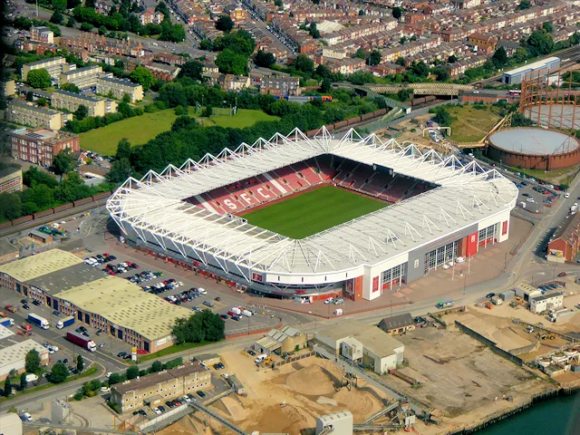
St Mary's Stadium David Dixon · CC BY-SA 2.0


Travel notes for Eastleigh
From Wikivoyage
Eastleigh is a town in Hampshire that sits between Winchester and Southampton. The town has a long history associated with the railway, being the site of a large railway works that at one time was the major employer in the area.
Understand+
The Borough of Eastleigh contains the town of Eastleigh, and many small villages and hamlets, including Chandler's Ford to the north and Bishopstoke to the east.
Perhaps the best-known piece of history associated with Eastleigh is that it is the home of the Spitfire (a famous World War II fighter plane). The aircraft was built, designed and first flown from what is now Southampton Airport. During its military service, Southampton Airport was known as HMS Raven, before it was renamed to Eastleigh Airport in 1947. The name was changed again to its current name in 1994 to mark the opening of the new terminal constructed there the year before.
The town also boasts a link to one of the UK's best known comics, Benny Hill. Indeed it was his work as a milkman in the town that spawned his well known "Ernie - the fastest milkman in the west" tune. The cartoon character 'Jane' and musician Heinz Burt are also connected with the borough.
Since the Pirelli Cable Works closed down in 1990, Eastleigh became a dormitory town, meaning that it has become home to many people who live there, but work somewhere else.
In 2006, Eastleigh was named as the ninth best place to live in the UK by the Channel 4 television programme The Best and Worst Places to Live 2006. The abundance of jobs and excellent transport links (motorways, trains, buses and planes) were named as some of the primary reasons for this award. Nearby Winchester was named the best place to live in the UK by the same programme.
Get in+
By train:
Wikivoyage has a guide to Rail travel in Great Britain
Eastleigh has good national rail links; the three stations serving the area are all on the South Western Main Line from London to Weymouth.
1 Eastleigh Station, Southampton Rd, SO50 9FL. The South Western Railway service from London Waterloo runs every 30 min to 1 hr, and the journey takes 1 hr 20 min. There are also frequent rail services to Eastleigh station from Southampton Central (13 min), Winchester (10 min), Portsmouth & Southsea (40 min), and Basingstoke (30 min). (updated Jun 2021)
2 Chandler's Ford Station, Station Ln, SO53 4DD. Very similar service pattern to Eastleigh station. (updated Jun 2021)
3 Southampton Airport Parkway Station, Wide Ln, SO18 2HW. Crosscountry and South Western services from Bournemouth (45 min), Reading (45 min), Birmingham New Street (2 hr 30 min) and Manchester Piccadilly (4 hr) are available. (updated Jun 2021)
By plane:
Year-round services from many airports across the British Isles to 4 Southampton Airport (SOU IATA), and a handful of continental cities and resorts. Travelling to Eastleigh town centre from Southampton Airport is simple, travel up the A335 until you get to Leigh Road, then turn left.
By car:
Eastleigh is 5 mi (8.0 km) north of Southampton City Centre. To travel from Southampton to Eastleigh, simply follow the A335 for Eastleigh or A33 for Chandler's Ford. Another option is to take the M271 from Westquay Shopping Centre until Junction 1, then take the M27 to Junction 5.
Eastleigh is near the end point of the M3 connecting the South Coast and M27 with Winchester (10 mi (16 km) away) and the rest of the country's motorway network. London is 75 mi (121 km) away via the M3, while Birmingham is 140 mi (230 km) via the M40, A34 and M3. Use junction 13 for Eastleigh and Chandler's Ford towns, but junction 11 for Marwell Zoo. If travelling from Portsmouth 20 mi (32 km) away, use the M27 and come off at junction 5.
Source: Wikivoyage · CC BY-SA 4.0 · abridged
Climate of Eastleigh
Best months for sightseeingBest months for sightseeing: June–August.
This month · November
A cold month
Day 11° · Night 5° · Rain 87 mm
- Hottest month
- July (day 22°)
- Coldest month
- February (night 2°)
- Wettest month
- November (87 mm)
- Driest month
- July (38 mm)
Bars: average monthly low and high temperature. Below: precipitation. Monthly averages for 1970–2000 at about 18 km resolution, adjusted for elevation. Highlighted months are mild and relatively dry. Source: WorldClim 2.1 (CC BY 4.0).
Show values as a table
| Month | Jan | Feb | Mar | Apr | May | Jun | Jul | Aug | Sep | Oct | Nov | Dec |
|---|---|---|---|---|---|---|---|---|---|---|---|---|
| Average high (°C) | 8° | 8° | 11° | 13° | 17° | 20° | 22° | 22° | 19° | 15° | 11° | 9° |
| Average low (°C) | 3° | 2° | 4° | 5° | 8° | 11° | 13° | 13° | 11° | 8° | 5° | 4° |
| Precipitation (mm) | 84 | 58 | 61 | 47 | 46 | 55 | 38 | 52 | 67 | 78 | 87 | 85 |
How to get to Eastleigh
The nearest airport is Southampton Airport (SOU), 2 km to the south as the crow flies. For international flights: London Heathrow Airport (LHR) (84 km). The nearest large city is Southampton, 8 km to the southwest.
Airports
- Southampton Airport (SOU) Southampton 2 kmsouth
- Bournemouth Airport (BOH) Bournemouth 40 kmsouthwest
- London Heathrow Airport (LHR) London 84 kmnortheast
Nearby large cities
- Southampton Population: 269.8K 8 kmsouthwest
- Portsmouth Population: 208.1K 26 kmsoutheast
- Basingstoke Population: 107.6K 38 kmnortheast
- Bournemouth Population: 163.6K 46 kmsouthwest
- Poole Population: 151.5K 53 kmsouthwest
Straight-line distances; road distances are longer. Airport data: OurAirports.
Day trips from Eastleigh
Within 100 km: 417 historic and cultural sites, 730 natural sites, 236 lakes, rivers and coasts.
0–25 km94 places
- Calshot Beach Beach 17 kmS
- Whale Island Island 24 kmSE
- Horsea Island Island 23 kmSE
- Burrow Island Island 24 kmSE
25–60 km454 places
- Portsea Island Natural site 27 kmSE
- Isle of Wight Island 32 kmS
- Brownsea Island Island 53 kmSW
- Avon Beach Beach 38 kmSW
60–100 km835 places
- St Nicholas Church Shoreham Attraction 76 kmE
- The Marlipins Museum Museum 77 kmE
- Chesil Beach Beach 93 kmSW
- Man O'War Beach Beach 75 kmSW
Straight-line distances.
Eastleigh and similar cities
Side by side with cities of similar size in the same country: population, elevation and climate.
| Measure | Eastleigh | Hamilton | Barry | Castlereagh |
|---|---|---|---|---|
| Population | 54.2K | 54.5K | 54.7K | 56.7K |
| Elevation | 11 m | 68 m | 25 m | 29 m |
| Summer day (hottest month) | 22° | 19° | 21° | 20° |
| Winter night (coldest month) | 2° | 1° | 2° | 1° |
| Annual rainfall | 758 mm | 1,363 mm | 1,019 mm | 880 mm |
| Best months | Jun–Aug | Jun–Aug | Jun–Aug | Jun–Aug |
| Distance | — | 563 km | 144 km | 505 km |
Climate values are 1970–2000 monthly averages; straight-line distance.
Nearby attractions & nature
Everything nearby-
Silverlake Stadium Landmark, Eastleigh District2.2 km SW
-
Bassett Avenue Mountain, Southampton4.2 km SW
-
Chilworth Mountain, Chilworth4.6 km W
-
Cranbury Park Mountain, Hursley4.8 km N
-
St Mary's Stadium Landmark, Southampton7.3 km SW
-
Harefield Mountain, West End5 km S
-
Marwell Zoo Attraction, Colden Common5.2 km NE
-
Ladwell Hill Mountain, Hursley5.8 km NW
Sources & licences
Data last updated: · 2 independent sources