- Elevation
- 86 m
- above sea level
- Local time
- UTC+00:00
- Europe/London · UTC+00:00
- Places inside
- 10
- listed under Kingsland
- Airports
- BHX Birmingham Airport76 km
- BRS Bristol Airport96 km
About Kingsland
Kingsland is a municipality. Location: Herefordshire, England. Elevation: 86 m. The best months to visit are June–August. The nearest airport is Birmingham Airport (76 km). Nearby sights include Middle Barns Hill and Eardisland Castle.
Photos of Kingsland
-
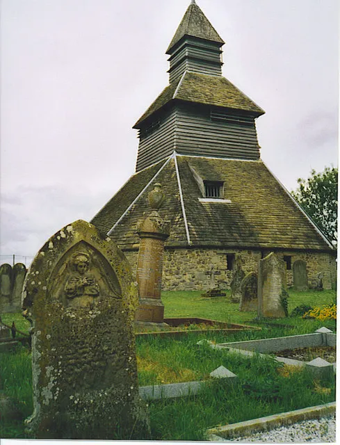
Church of St Mary Belfry Colin Smith · CC BY-SA 2.0

Climate of Kingsland
Best months for sightseeingBest months for sightseeing: June–August.
This month · November
A cold month
Day 10° · Night 3° · Rain 70 mm
- Hottest month
- July (day 21°)
- Coldest month
- February (night 1°)
- Wettest month
- January (80 mm)
- Driest month
- July (45 mm)
Bars: average monthly low and high temperature. Below: precipitation. Monthly averages for 1970–2000 at about 18 km resolution, adjusted for elevation. Highlighted months are mild and relatively dry. Source: WorldClim 2.1 (CC BY 4.0).
Show values as a table
| Month | Jan | Feb | Mar | Apr | May | Jun | Jul | Aug | Sep | Oct | Nov | Dec |
|---|---|---|---|---|---|---|---|---|---|---|---|---|
| Average high (°C) | 7° | 7° | 10° | 12° | 16° | 19° | 21° | 21° | 18° | 14° | 10° | 8° |
| Average low (°C) | 1° | 1° | 2° | 4° | 6° | 9° | 11° | 11° | 9° | 6° | 3° | 2° |
| Precipitation (mm) | 80 | 55 | 60 | 50 | 51 | 58 | 45 | 61 | 66 | 69 | 70 | 78 |
How to get to Kingsland
The nearest airport is Birmingham Airport (BHX), 76 km to the east as the crow flies. The nearest large city is Worcester, 41 km to the east.
Airports
- Birmingham Airport (BHX) Birmingham, West Midlands 76 kmeast
- Bristol Airport (BRS) Bristol 96 kmsouth
- Cardiff International Airport (CWL) Cardiff 102 kmsouth
Nearby large cities
- Worcester Population: 101.7K 41 kmeast
- Telford Population: 155.6K 54 kmnortheast
- Dudley Population: 199.1K 57 kmnortheast
- Gloucester Population: 132.4K 57 kmsoutheast
- Wolverhampton Population: 263.7K 60 kmnortheast
Straight-line distances; road distances are longer. Airport data: OurAirports.
Day trips from Kingsland
Within 100 km: 1,037 historic and cultural sites, 2,450 natural sites, 155 lakes, rivers and coasts.
0–25 km278 places
- The Island Island 6 kmE
- Titterstone Clee Hill Mountain 22 kmNE
- High Vinnalls Mountain 12 kmN
- Burrow Mountain 23 kmN
25–60 km1,260 places
- Alney Island Island 57 kmSE
- Bevere Island Island 39 kmE
- Withymoor Island Island 57 kmNE
- Pen-y-gareg Reservoir Lake 56 kmW
60–100 km2,104 places
- Flat Holm Island 99 kmS
- Sully Island Island 98 kmS
- Glover's Island Island 61 kmE
- Crescent Wood Island Island 78 kmE
Straight-line distances.
Places in Kingsland
10 placesBar: population relative to the most populous place in this list.
Cities & villages8
- Arrow Green · Village
- Aston · Village
- Becknell · Village
- Cobnash · Village
- Lawton · Village
- Mortimer's Cross · Village
- Shirl Heath · Village
- West Town · Neighbourhood
Heritage & sights1
- Kingsland Castle · Historic site
Nearby attractions & nature
Everything nearby-
Middle Barns Hill Mountain, Eardisland3.6 km W
-
Eardisland Castle Historic site, Eardisland3.9 km SW
-
Shobdon 2 Historic site, Shobdon4.4 km W
-
Comfort Castle Historic site, Leominster5.9 km E
-
Cock Croft Hill Mountain, Leominster5.2 km SE
-
Church of St Mary Belfry Historic site, Pembridge6.7 km SW
-
Lower Hyde Moat Historic site, Leominster6.1 km S
-
Shobdon Court Castle Historic site, Shobdon5.3 km W
Sources & licences
Data last updated: